
The Tuia Mātauranga Pōkai Whenua GeoTour follows the footsteps of early explorers of Aotearoa New Zealand taking you to places where leaders of the past searched for food, resources and ways to adapt and survive in this new land.
Use the Pōkai Whenua GeoTour as your classroom to explore the stories of the past, in the present, to preserve what is unique in Aotearoa New Zealand for the future.
Collect the codewords to get the Geocoin puzzle pieces
To be able to complete this GeoTour and receive your special Geocoin collectable, remember to take a note of the codeword placed in the cache. This will need to be recorded in your passport which can be downloaded here.
63 of the 150 Pōkai Whenua GeoTour caches will contain a randomly placed special FTF token (a replica of the Tuia Mātauranga GeoTour commemorative coin). This is yours to keep! If you find more than one, you might consider leaving it for the next person who finds the cache.
Historic Background
The Hanmer Plains were part of the ara tawhito (traditional travel routes) of Māori. The area was known as Mānia-rauhea, or “plain of shining tussock”, and although no permanent settlements have been uncovered in the area, campsites have been found indicating it was a temporary stopping point for travellers journeying along the trails. These travellers were either journeying between settlements in northern and southern parts of the South Island, or enroute to the greenstone trails that connected the east and west coasts.
It is unclear whether Māori used the hot springs, as there is no record of them mentioning the pools to the Europeans whom they guided through the area, but since they were very familiar with the plains, it is highly likely that the springs were known and used by them. This is further supported by the existence of a legend, which tells of the warrior Tamatea who was unable to start a fire, and in fear of freezing, called on an ariki (chief) of the north island volcanoes to send fire. A flame was sent to Tamatea in Banks Peninsula and some of it landed in Hanmer Springs giving rise to the hot pools.
In 1859, William Jones, a farm manager from Culverden, was credited with the discovery of the hot springs when he investigated low-lying fog he observed while walking on a nearby track. During the nineteenth century natural thermal springs were thought to be ‘healing waters’ and resorts or spas were built around them in order to utilise their healing properties. Hanmer was no exception and Jones’ discovery soon spread leading to an influx of visitors.
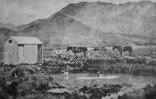
Figure 1: Bathers enjoying the hot pools during the 1880s
In 1860, the Government recognised these healing opportunities and reserved the springs for a spa resort. Visitors regularly visited the pools and dressing sheds were soon built. By 1864 the Waiau Ferry Bridge had been built providing better access to the area and leading to a dramatic increase in the number of visitors to the site. The Government Lands Department took over the development of the springs in 1883 and set about improving the pools and establishing facilities (Figure 1).
In 1897, the Government built an accommodation house, described as a sanatorium, which contained eight first class rooms. The patients were under the care of a medical officer and treatment included bathing, drinking the waters and inhalation of the vapours. The grounds also included recreational facilities for tennis, bowls and croquet.
The sanatorium burnt down in 1914 and was replaced by the Queen Mary Hospital for Sick and Wounded Soldiers, which treated war veterans suffering from mental and nervous disorders (Figure 2). The hospital underwent many changes and extensions over the decades before finally closing its doors in 2003. By all accounts, it was a wonderful facility where patients were treated with sympathy and respect.
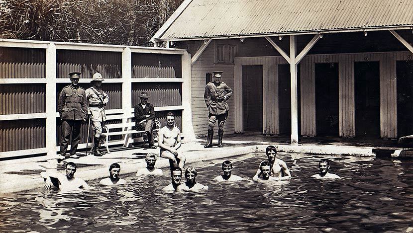
Figure 2: War veterans taking the waters post 1916
The Geocache
In order to discover the final location of the cache you need to visit three waypoints and collect the relevant information in order to get the final coordinates. Please remember to securely tuck the cache away and replace as found.
Stage 1: Locate the plaque at the coordinates
The number of the month of the year = A
Stage 2: Locate the information panel
The number of patients accommodated = BC
The year of the Sanatorium layout = 1D0E
Stage 3: Locate the information panel
The final year the doctor was Medical Superintendent = 194F
Checksum = 25
The final location is at: S42 31.(F-B)(A+F)(C-B) E172 49.(D-F)(B-E)(A-F+B)