
La Earthcache / The Earthcache
Un grand merci à Carfantin pour sa cache traditionnelle "Le Petit Pic St Loup - GC3FYEM" qui nous a permis de découvrir ces très belles formations tectoniques !
► Contexte géologique local
Le pied du Roc Verdier est occupé par deux formations sédimentaires du Crétacé inférieur mis en contact par une faille :
- des calcaires gris à débit noduleux du Berriasien inférieur.
- des Marnes du Berriasien moyen.
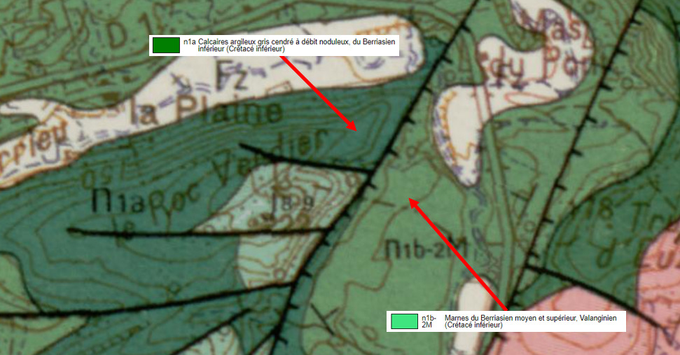
Ces formations sédimentaires ont été fortement impactées par les compressions tectoniques de l'orogenèse pyrénéenne il y a 40 Ma. Comment se sont-elles comportées ?
► Ca plie ou ça casse, une histoire de compétence
Cette notion est relative à la façon dont une roche peut se déformer. Une roche est dite compétente si elle est rigide, entrainant sous une contrainte sa fracturation plutôt que son plissement.
A contrario, une roche est dite ductile lorsqu'elle peut se déformer sans « cassure » (mise en place plis souples, rubanées). Elle est donc incompétente.
La compétence d'une roche est fonction de sa nature.
A faible profondeur, les grès et calcaires sont compétentes alors que les marnes sont incompétents.
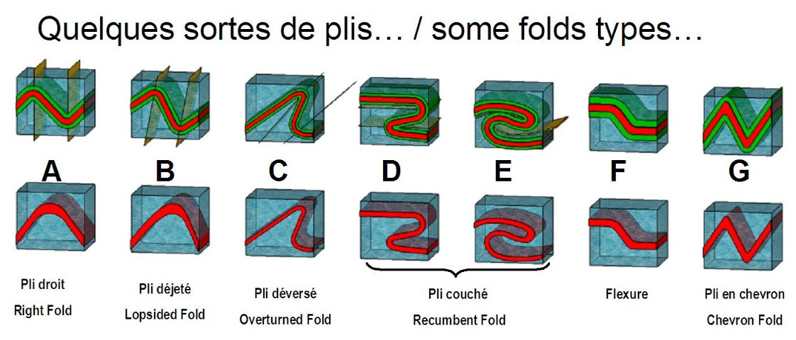
► Classification descriptive des plis
Un pli est une structure courbe due à une déformation ductile de la roche.
Plusieurs caractéristiques permettent de classifier un pli:
~ l'épaisseur du pli : un pli est isopaque si l'épaisseur des couches est constante, anisopaque sinon.

~ le pendage du plan axial : un pli est dit droit si son plan axial est vertical, déjeté s'il est oblique et couché si son plan axial est presque horizontal

La complexité des plis détermine une classification descriptive, dont voici quelques exemples :
► Pendage d'une roche sédimentaire
Pour qualifier un pendage d'une couche de roche litée, il faut deux valeurs :
- l'inclinaison des lits par rapport à un plan à l'horizontale, exprimée en degrés.
- la direction du pendage, qui se mesure à 90 degrés de la direction de la couche et définit un angle par rapport au Nord.

L'intensité du pendage peut être graduée de la façon suivante :
- le pendage est nul si le plan (ou la ligne qui lui correspond) mesuré est horizontal. Dans ce cas, il n'y a pas de direction, ou plutôt, le plan est dans toutes les directions.
- le pendage est faible si le plan (ou la ligne) mesuré est presque horizontal (moins de 30 degrés).
- le pendage est fort si le plan (ou la ligne) mesuré est presque vertical (plus de 60 degrés).
- le pendage est dit vertical, si le plan (ou la ligne) mesuré est verticale. Dans ce cas, il n'y a pas de direction pour une ligne, mais il y a une (ou plutôt deux) direction pour un plan.
► Faille, définition et caractéristiques
On appelle faille une cassure suivi d'un déplacement relatif des compartiments qu'elle détermine.
~ Types de faille
- Faille normale : elle correspond à un mouvement d’extension entre deux blocs et l’effondrement d’un bloc par rapport à un autre. Le plan de faille est incliné en descendant vers le bloc affaissé.
- Faille inverse : elle correspond à un mouvement de compression entre deux blocs avec un rejet pour l’un des deux blocs. Le plan de faille surplombe le compartiment affaissé.

~ Rejet de faille
Le rejet de faille correspond à la mesure du décalage qui s’est produit entre les deux compartiments séparés. Ce décalage comprend une composante verticale ou horizontale.
La synthèse de ces composantes est le rejet stratigraphique qui se mesure le long d’un miroir de faille entre deux strates d'origine commune dans les deux compartiments.

► Local geological context
The foot of Roc Verdier is occupied by two sedimentary formations from the Lower Cretaceous brought into contact by a fault: gray limestones with nodular flow from the Lower Berriasian and Marls from the Middle Berriasian.
Like the sedimentary formations of the region, these formations were strongly impacted by the tectonic compressions of the Pyrenean orogeny 40 Ma ago. How did they behave?
► It bends or it breaks, a story of competence
This notion relates to how a rock can deform. A rock is said to be competent if it is rigid and therefore tends to fracture rather than bend when subjected to a state of stress.
Conversely, a rock is said to be ductile when the latter can be deformed without “breaking” (placing flexible, banded folds), it is therefore incompetent.
The competence of a rock depends on its nature. At shallow depth, sandstones and limestones are competent, while marls or schists are incompetent.
► Classification folds
A fold is a curved structure due to a ductile rock deformation.
Many features used to classify a crease. Among the most frequent qualifiers are:
~ Fold thickness : a bend is isopach if the thickness of the layers is constant, anisopaque otherwise.
~ The dip of the axial plane : a fold is said right if the axial plane is vertical, lopsided if oblique and lying if its axial plane is almost horizontal.
The complexity of shapes pleated is causing a descriptive classification, with the following main types (see French description).
► Dip of sedimentary rock
To qualify the dip of a layered rock, like sedimentary limestone, it takes two values:
- The inclination of the beds with respect to a plane to the horizontal, in degrees.
- The direction of dip, measured at 90 degrees to the direction of the layer and defines an angle to the North.
The intensity of the dip can be graded as follows:
- Dip is zero if the plan (or the line that corresponds to it) measured is horizontal. In this case, there is no direction, or rather, the plan is in all directions.
- Dip is low if the plan (or line) is measured almost horizontal (under 30 degrees).
- Dip is strong if the plan (or line) is measured almost vertical (over 60 degrees).
- Vertical dip is said, if the plan (or line) is measured vertically. In this case, there is no direction to a line, but there is one (or rather two) direction to a plan.
► Geological fault, definition and characteristics
Geological fault called a break in the continuity of land originally at the same level and which is accompanied by a relative displacement of compartments it determines.
~ Types of geological faults
- Normal fault: this corresponds to an expansion movement (expansion) in the space between the two blocks and the collapse of a block with respect to another. The fault plane is tilted down toward the collapsed block.
- Reverse faults: it corresponds to a compression or movement of approximation between two blocks with a vertical discharge to one of the two blocks. The fault plane overlooking the sunken compartment.
~ Rejection flaw
The flaw rejection corresponds to the measurement of the shift that occurred between the two separate compartments. This offset includes a vertical or horizontal component.
There are different types of rejections, but in the case of faults Repentie, most telling is the rejection stratigraphic, which corresponds to a drop measured along an oblique Fault plane between two layers having a common origin in both compartments, and that is a component of two vertical rejections.
► Sources bibliographiques / Bibliographical sources
Les Questions / The Questions
Questions pour valider :"Petite leçon de compression au Roc Verdier"
Questions to validate: "A little compression lesson at Roc Verdier"
- Question 0 : Prenez une photo de vous ou d'un élément dans le ru du Terrieu (mais pas au WPs).
Cette photo devra au choix nous être transmise avec les réponses ou être ajoutée à votre log.
-Question 0 : Take a photo of yourself or an element in the Terrieu ru (but not at the WPs).
This photo must either be sent to us with the answers or added to your log.
Point 1 : N 43° 47.230 E 003° 51.324
Suivez les différents TrailHeads jusqu'au WP1. Si un endroit du fond du ru du Terrieu est ennoyé, prenez le TrailHead montant sur le talus le long de la clôture.
Vous voici devant des strates redressées de cette formation sédimentaire du Berriasien.
Follow the different TraiHeads up to WP1. If a spot at the bottom of the Terrieu ru is flooded, take the TrailHead up the embankment along the fence.
Here you are in front of folded strata of this sedimentary formation of the Berriasian.
- Question 1 : Qualifiez l'intensité du pendage des strates à cet endroit.
- Question 1 : Qualify the dip of the strata at this location.
Entre les WP1 et WP2
Entre les deux WPs, observez le comportement des strates face à la compression (plis/failles).
Between WP1 and WP2, observe the behavior of the strata in the face of compression (folds / faults).
- Question 2 : Comment pouvez-vous qualifier cette roche en terme de compétence ? Déduisez en la nature de la formation du Berriasien le long du Ru du Terrieu.
- Question 2 : How can you qualify this rock in terms of skill? Deduce in nature from the formation of the Berriasian along the Ru du Terrieu.
Point 2 : N 43° 47.256 E 003° 51.314
Vous voici devant un affleurement de strates plissées et faillées (photo WP2).
Here you are in front of an outcrop of folded and faulted strata (photo WP2).
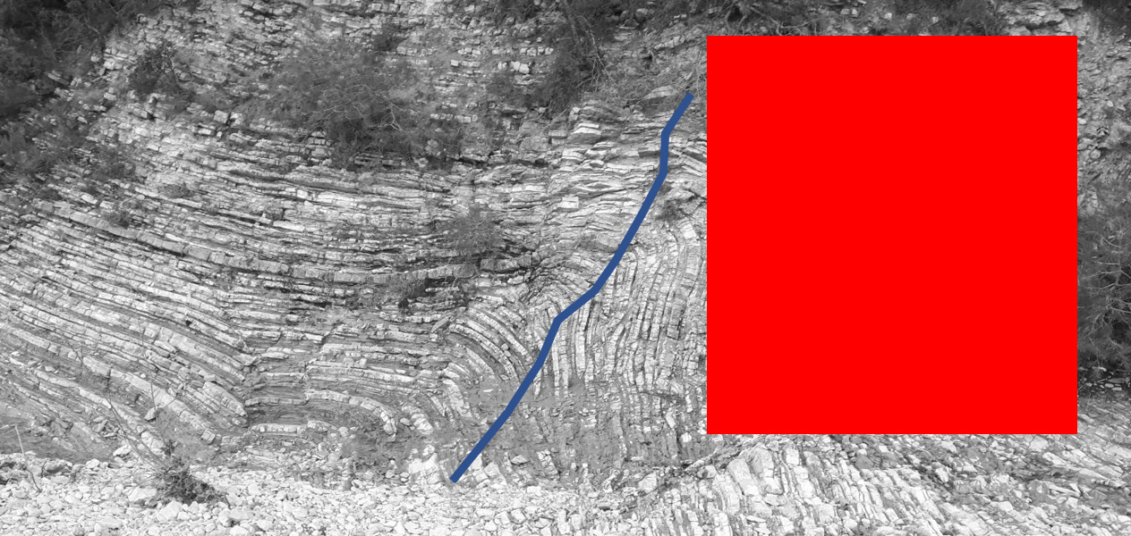
- Question 3 : Caratérisez le pli sous la zone rouge (épaisseur, pendage du plan axial, angle de plissement). Parmi la classification des plis, duquel s'agit-il ?
- Question 3: Characterize the fold under the red zone (thickness, dip of the axial plane, fold angle). Among the classification of folds, which one is it?
- Question 4 : Sous le trait bleue se trouve une faille. S'agit-il d'une faille normale ou inverse (justifiez votre réponse). Evaluez le rejet stratigraphique de cette faille.
- Question 4 :Below the blue line is a fault. Is it a normal or reverse flaw (justify your answer). Evaluate the stratigraphic release of this fault.
Vous pouvez vous loguer sans attendre notre confirmation,
mais vous devez nous envoyer les réponses en même temps soit par mail via notre profil (
fafahakkai), soit via la messagerie geocaching.com (Message Center).
S'il y a des problèmes avec vos réponses nous vous en ferons part.
Les logs enregistrés sans réponses seront supprimés.
You can log this cache without waiting for our confirmation, but you must send us the answers at the same time, by e-mail via our profile (fafahakkai) or by the system of Message Center of geocaching.com.
If there is a problem with your answers we will notify you. The logs recorded without answers will be deleted.
Rappel concernant les « Earthcaches »: Il n'y a pas de conteneur à rechercher ni de logbook à renseigner. Il suffit de se rendre sur les lieux, de répondre aux questions ci-dessus et de nous renvoyer les réponses.
Reminder concerning "Earthcaches": there is neither a container to look for nor a logbook to sign. One need only go to the location, answer to the differents questions and send us the answers.