Waterfalls
A waterfall is a place where water flows over a vertical drop or a series of steep drops in the course of a stream or river. Waterfalls also occur where meltwater drops over the edge of a tabular iceberg or ice shelf.
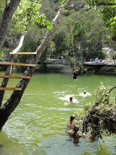
The Twin Falls and Sculpture Falls areas of the Barton Creek Greenbelt are hidden local secrets. It’s about a half-mile hike on a well-defined trail to reach Twin Falls from the closest entrance. But once you arrive you’ll be treated to relaxing shallow stream waters, although there are plenty of rocky areas for adventurous climbing and exploring the falls. Hike a mile further and you’ll reach Sculpture Falls, another hidden gem watering hole.
Through erosion!
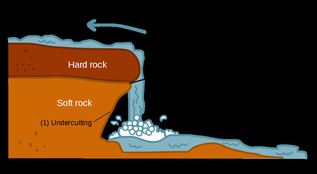
With water flowing over soft rock, soft sediments are displaced over the edge line until the rock hardens, creating a waterfall. This is what is called a fall line.
A stream's velocity increases as it nears a waterfall, increasing the amount of erosion taking place. The movement of water at the top of a waterfall can erode rocks to be very flat and smooth. Rushing water and sediment topple over the waterfall, eroding the plunge pool at the base. The crashing flow of the water may also create powerful whirlpools that erode the rock of the plunge pool beneath them. The resulting erosion at the base of a waterfall can be very dramatic, and cause the waterfall to "recede."
Different types of Waterfalls
Plunge: Water descends vertically, losing contact with the bedrock surface.
Horsetail: Descending water maintains some contact with bedrock.
Cataract: A large, powerful waterfall.
Multi-step: A series of waterfalls one after another of roughly the same size each with its own sunken plunge pool.
Block: Water descends from a relatively wide stream or river.
Cascade: Water descends a series of rock steps.
Segmented: Distinctly separate flows of water form as it descends.
Tiered: Water drops in a series of distinct steps or falls.
Punchbowl: Water descends in a constricted form and then spreads out in a wider pool.
Fan: Water spreads horizontally as it descends while remaining in contact with bedrock.
Karsts
Karst is a topography formed from the dissolution of soluble rocks. It is characterized by underground drainage systems with sinkholes and caves.
On exposed surfaces, small features may include solution flutes (or rillenkarren), runnels, limestone pavement (clints and grikes), collectively called karren or lapiez.
Karst-related features
Many karst-related terms derive from South Slavic languages, entering scientific vocabulary through early research in the Western Balkan Dinaric Alpine karst.
Abîme, a vertical shaft in karst that may be very deep and usually opens into a network of subterranean passages
Cenote, a deep sinkhole, characteristic of Mexico, resulting from collapse of limestone bedrock that exposes groundwater underneath
Doline, also sink or sinkhole, is a closed depression draining underground in karst areas. The name "doline" comes from dolina, meaning "valley", and derives from South Slavic languages.
Foibe, an inverted funnel-shaped sinkhole
Karst fenster ("karst window"), a feature where a spring emerges briefly, with the water discharge then abruptly disappearing into a nearby sinkhole
Karst spring, a spring emerging from karst, originating a flow of water on the surface
Limestone pavement, a landform consisting of a flat, incised surface of exposed limestone that resembles an artificial pavement
Losing stream, sinking river or ponornica in South Slavic languages
Polje (karst polje, karst field), a large flat specifically karstic plain. The name "polje" derives from South Slavic languages.
Ponor, same as estavelle, sink or sinkhole in South Slavic languages, where surface flow enters an underground system
Scowle, porous irregular karstic landscape in a region of England
Turlough (turlach), a type of disappearing lake characteristic of Irish karst
Uvala, a collection of multiple smaller individual sinkholes that coalesce into a compound sinkhole. Word derives from South Slavic languages.
Questions for qualification:
Question 1: At the waterfall, describe the effect of water as an erosive agent. Be sure to specify coloration changes, texture, etc...
Question 2: Describe the relation between the waterfall and characteristics of karsts. Be sure to use both language in the geocache page and specific aspects of the waterfall. What type of waterfall is this?
Question 3: What specific karst features are visible at the waterfall?
Question 4: As proof that you visited this location, please post a picture of yourself or group with the waterfall!