Attention, l’Earthcache est accessible à marée basse. Horaires des marées sont ici. L’accès se fait par la plage et en escaladant les rochers.
Vous vous engagez de votre propre initiative dans la recherche de cette cache à vos risques et périls. Je décline donc toute responsabilité en cas de problème.
Il s'agit d'une Earthcache, il n'y a pas de récipient à chercher.
Discordance à Trez Bihan
Discordance de la Formation du Cap de la Chèvre (Paléozoïque) sur le Briovérien (Protérozoïque).
La pointe de Beg ar Gwin expose le contact discordant entre deux ensembles géologiques :
Les schistes et grès du Briovérien
sont datés entre -600 et -540 millions d’années (ère Protérozoïque). Les schistes et grès briovériens sont les plus anciennes roches de la presqu’île de Crozon, ils font partie de la formation des Phyllades de Douarnenez. Elles exposent des alternances de schistes (anciens dépôts vaseux) et de grès (anciens dépôts sableux). Ces anciens dépôts, initialement accumulés en couches horizontales sur un fond marin, ont été plissés une première fois lors de l'orogenèse cadomienne (-560 à -540 Ma), puis redressés à la verticale lors de la formation de la chaîne de montagnes hercynienne (varisque) - 320 millions d’années. La couleur rouge/verte est trompeuse et ne dépend ici que de l’état oxydé ou réduit du fer. Ainsi le Briovérien, généralement de couleur verte, peut avoir été oxydé avant le dépôt du conglomérat. La couleur lie-de-vin est à l’origine de la dénomination de cette pointe en breton Beg ar Gwin « pointe du vin ».
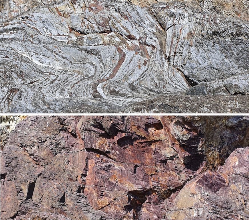
Les Schistes et grès rouges du Cap de la Chèvre
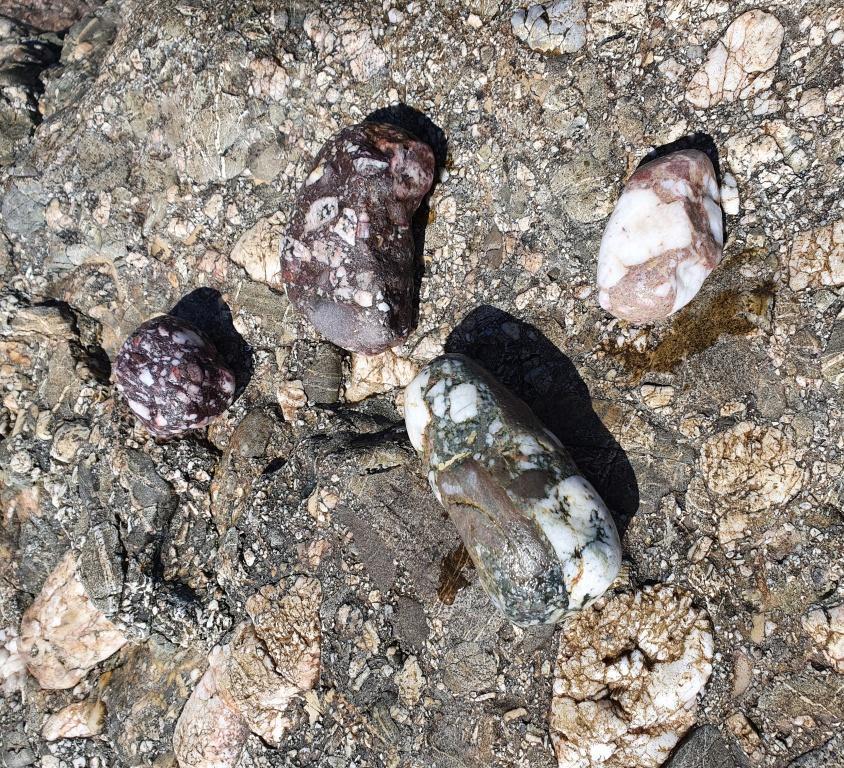
sont les premiers dépôts sédimentaires de l'ère Paléozoïque (Ordovicien). Ces derniers débutent par un conglomérat (- 480 millions d’années) constitué de petits galets et graviers soudés entre eux. Sur la plage on les observe les gros blocs éboulés de ces conglomérats grossiers à quartz, grès et quartzites dans une matrice rougeâtre riche en oxydes de fer. Ce faciès conglomératique marque la base des Séries rouges, ou Formation du Cap de la Chèvre.
Discordance
Une discordance correspond à tout changement dans l'enregistrement des dépôts de roches sédimentaires. Cela peut représenter par exemple une ancienne surface d'érosion séparant un ensemble de strates plissées lors d'une phase tectonique, d'un autre ensemble de strates non plissées qui elles n'ont pas été affectées par l'évènement tectonique car déposées postérieurement.
A la pointe de Beg ar Gwin la discordance est la rupture de continuité entre les deux ensembles, dont l’orientation des strates et l’âge diffèrent. Cette surface matérialise ici le contact entre deux ères géologiques (Briovérien et Ordovicien).
Au-dessus des schistes et petits bancs de grès verdâtre du Briovérien, redressés à la verticale et de direction nord-sud (visibles en pied de falaise) reposent en discordance des bancs massifs de conglomérat, également redressés mais cette fois de direction est-ouest. La série se poursuit en remontant la falaise par des alternances de grès et de schistes, également visibles depuis le chemin côtier. Plus haut dans le bois de conifères, la Série rouge passe progressivement au Grès armoricain.
Cette série rouge intercalée entre Briovérien et Grès armoricain correspond à des dépôts continentaux, des éboulis de pentes (conglomérats) passant à des dépôts fluviatiles et de plaines alluviales (schistes et grès), avant d’être finalement ennoyés par la mer. Ces dépôts passent alors à des sables marins à l’origine du Grès armoricain.
Histoire géologique de la Presqu’île de Crozon schématisée
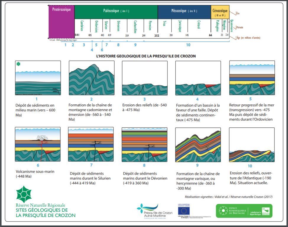
- Dépôt des sédiments du Briovérien en milieu marin (Phyllades de Douarnenez). Quelques pillows (laves en coussins) témoignent de volcanisme sous-marin durant la sédimentation. (Précambrien terminal à Cambrien basal, 550 à 530 Ma environ).
- Formation de la chaîne de montagne Cadomienne développement de failles normales et formation de blocs basculés. Plis de glissement et émersion.
- Érosion des reliefs du Briovérien.
- Dépôt en discordance des premiers niveaux paléozoïques (conglomérat et schistes rouges du Cap de la Chèvre) en milieu continental, puis marin.
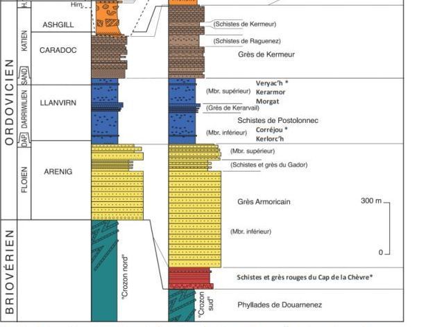
- Dépôt des sédiments du Grès Armoricain en milieu marin suivi de ceux de la Formation de Postolonnec et de la Formation de Kermeur (de 475 à 450 Ma environ).
- Volcanisme de la Formation de Rosan (Ordovicien Supérieur) sous faible tranche d’eau (cendres, ponces, coulées…)
- Dépôts glacio-marins (Formation de Cosquer, Ordovicien terminal) suivis des séries du Silurien (entre 440 et 419 Ma environ).
- Dépôts de sédiments marins du Dévonien (entre 419 et 360 Ma environ).
- Formation de la chaîne hercynienne (varisque) conduisant aux plissements du Paléozoïque, à de nouvelles déformations du Briovérien et au développement de nombreux accidents tectoniques (failles inverses et décrochements).
- La chaîne hercynienne s’accompagne d’une émersion suivie d’une longue phase d’érosion.
Sources
Wikipedia
https://www.reservepresquiledecrozon.bzh/
https://geopark.pnr-armorique.fr/
https://sgmb.univ-rennes1.fr/
Sites géologiques de la Presqu’île de Crozon
Vidal, Muriel : Géotourisme en Presqu’île de Crozon
Questions pour valider cette Earthcache :
- Qu’est-ce qu’une discordance ?
- Sur le schéma de l’histoire géologique de la Presqu’ile de Crozon à partir de quelle image on peut parler de la discordance ? Pourquoi ?
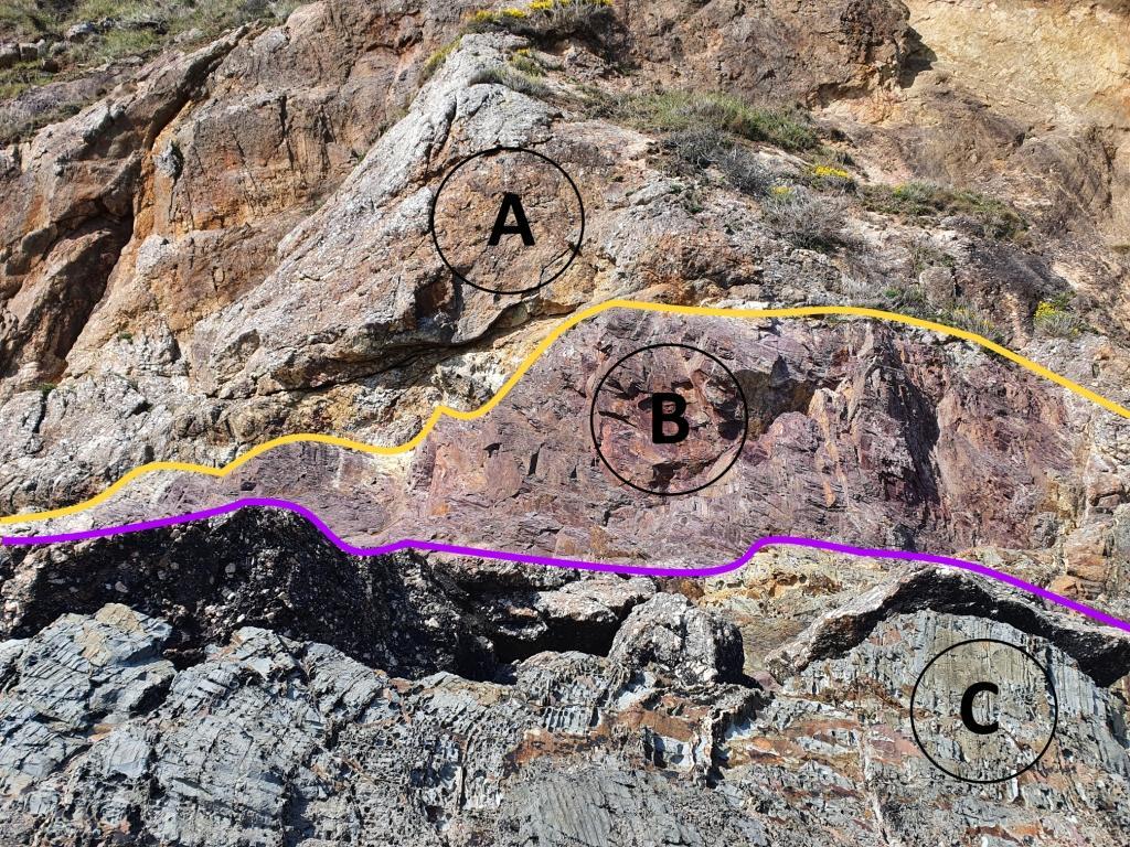
- Observez bien l’affleurement. Quelles sont les trois roches A, B et C ?
- Où, selon vous, se situe la discordance entre les Schistes et grès du Briovérien et les Schistes et grès rouges du Cap de la chèvre ? Est-elle matérialisée par la ligne mauve ou jaune ? Pourquoi ?
- Une photo de vous ou d’un objet vous représentant sur le site.

Loguez cette cache "Found it" et envoyez-moi vos propositions de réponses soit via mon profil, soit via la messagerie geocaching.com (Message Center), et je vous contacterai en cas de problème. Les logs enregistrés sans réponses seront supprimés.
English version
Please note, the Earthcache is accessible at low tide. Tide times are here. Access is via the beach and by climbing the rocks.
You engage in the search for this cache on your own initiative at your own risk. I therefore decline all responsibility in the event of a problem.
This is an Earthcache, there is no container to look for.
Unconformity at Trez Bihan
Unconformity between the Cap de la Chèvre Formation (Paleozoic) and the Brioverian (Proterozoic).
Pointe de Beg ar Gwin exposes the nonconformable contact between two geological groups:
Brioverian schists and sandstones
are dated between -600 and -540 million years ago (Proterozoic era). Brioverian schists and sandstones are the oldest rocks of the Crozon peninsula, they are part of the Phyllades de Douarnenez formation. They expose alternations of shale (old muddy deposits) and sandstone (old sandy deposits). These ancient deposits, initially accumulated in horizontal layers on a seabed, were folded for the first time during the Cadomian orogeny (-560 to -540 Ma), then straightened vertically during the formation of the Hercynian (Varisque) mountain range - 320 million years ago. The red / green color is misleading and here only depends on the oxidized or reduced state of the iron. Thus the Brioverian, generally green in color, may have been oxidized before the deposition of the conglomerate. The wine color is at the origin of the name of this tip in Breton Beg ar Gwin "tip of the wine".
The Schists and red sandstones of Cap de la Chèvre
are the first sedimentary deposits of the Paleozoic (Ordovician) era. These begin with a conglomerate (- 480 million years) made up of small pebbles and gravel welded together. On the beach we can see the large crumbling blocks of these coarse quartz, sandstone and quartzite conglomerates in a reddish matrix rich in iron oxides. This conglomerate facies marks the basis of the Red Series, or Cap de la Chèvre Formation.
Unconformity
A mismatch is any change in the record of sedimentary rock deposits. This can represent, for example, an old erosion surface separating a set of folded strata during a tectonic phase, from another set of non-folded strata which were not affected by the tectonic event because they were deposited later.
At La pointe de Beg ar Gwin the unconformity is the rupture of continuity between the two sets, of which the orientation of the strata and the age differ. This surface here materializes the contact between two geological eras (Brioverian and Ordovician).
Above the shales and small greenish sandstone banks of the Brioverian, straightened vertically and in a north-south direction (visible at the foot of the cliff) rest in discordance massive conglomerate banks, also straightened but this time in an east-west direction. The series continues up the cliff by alternating sandstone and shale, also visible from the coastal path. Higher up in the coniferous wood, the Red Series gradually changes to Armorican Sandstone.
This red series interspersed between Briovérien and Grès Armoricain corresponds to continental deposits, scree slopes (conglomerates) passing to fluvial deposits and alluvial plains (schists and sandstone), before being finally flooded by the sea. then to sea sands at the origin of the Armorican sandstone.
Geological history of the Crozon peninsula schematized

1. Deposit of Briovérien sediments in a marine environment (Phyllades de Douarnenez). A few pillows (pillow lavas) testify to submarine volcanism during sedimentation. (Terminal Precambrian to Basal Cambrian, approximately 550 to 530 Ma).
2. Formation of the Cadomian mountain range, development of normal faults and formation of tilted blocks. Slip and emersion folds.
3. Erosion of the Briovérien reliefs.
4. Unconventional deposit of the first Paleozoic levels (conglomerate and red schists of the Cap de la Chèvre) in a continental environment, then marine.
5. Deposition of the Armorican Sandstone sediments in a marine environment followed by those of the Postolonnec Formation and the Kermeur Formation (from approximately 475 to 450 Ma).
6. Volcanism of the Rosan Formation (Upper Ordovician) under a small slice of water (ash, pumice, flows ...)
7. Glacio-marine deposits (Cosquer Formation, Terminal Ordovician) followed by the Silurian series (between 440 and 419 Ma approximately).
8. Deposits of marine sediments from the Devonian (between 419 and 360 Ma approximately).
9. Formation of the Hercynian chain (variscus) leading to Paleozoic folds, new Brioverian deformations and the development of numerous tectonic accidents (reverse faults and recesses).
10. The Hercynian range is accompanied by an emersion followed by a long phase of erosion.
Questions to validate this Earthcache:
1. What is a unconformity?
2. On the diagram of the geological history of the Presqu’ile de Crozon from which image we can speak of the unconformity? Why ?
3. Observe the outcrop. What are the three rocks A, B and C?
4. Where, in your opinion, is the unconformity between the Brioverian schists and sandstones and the Cap de la Chèvre schists and red sandstones? Is it represented by the purple or yellow line? Why ?
5. A photo of you or an object representing you on the site.
Log this "Found it" cache and send me your suggested answers either via my profile or via geocaching.com (Message Center), and I will contact you in the event of a problem. Logs recorded without response will be deleted.