The Heart of the Civil War Heritage Area Geotrail
Rocky Springs Chapel

You're invited to take a journey through the Maryland's Heart of the Civil War.
The Heart of the Civil War Heritage Area Geotrail was first launched in the fall of 2016 with geocaches hidden within Maryland's Carroll, Frederick, and Washington Counties. In the spring of 2021, the Geotrail was updated with five additional geocaches and an Adventure Lab.
The Heart of the Civil War Heritage Area (HCWHA) is an area rich in history, covering portions of Maryland’s Carroll, Frederick and Washington Counties. It is located just below the Mason-Dixon Line, generally viewed as the dividing line between North and South, and above the Potomac River. With one foot in the north, and one foot in the south, the story of the Civil War can be told nowhere better than in this part of Maryland.
Between 1861 and 1865, the Civil War impacted every Maryland resident, many directly as a result of the war that was waged within the state’s borders. Some families faced financial ruin after troops ravaged their land. Thousands of fathers, sons and brothers became casualties of war. For enslaved Marylanders, the conflict ultimately brought about freedom as the new state constitution of November 1864 abolished slavery.
This region witnessed three major military movements during the Civil War: the Maryland (also known as Antietam) Campaign in the fall of 1862, the Gettysburg Campaign in the summer of 1863, and the march to Washington led by Jubal Early in the summer of 1864.Geocachers can visit significant sites from each of these three operations on the Heart of the Civil War GeoTrail.
The mission of the Heart of the Civil War Heritage Area is to promote the stewardship of our historic, cultural, and natural Civil War resources; encourage superior visitor experiences; and stimulate tourism, economic prosperity, and educational development, thereby improving the quality of life in our community for the benefit of both residents and visitors.
Geocachers who find the locations of at least 13 HCWHA caches are eligible for a free prize and may purchase a Geocoin (while supplies last of both). To record and redeem the finds, Geocachers must download a passport from the Heart of the Civil War website and record the code word from at least 13 HCWHA geocaches. Geocachers may have their passports validated in person at the Newcomer House at Antietam National Battlefield or at the Visitor Centers in Westminster or Frederick. See the Heart of the Civil War Heritage Area’s websitefor details on Geocoin and free prize availability.
Participating in the HCWHA geotrail is fun and we hope that many people join in. However, it is not a requirement for logging your find on this cache once you find the container.
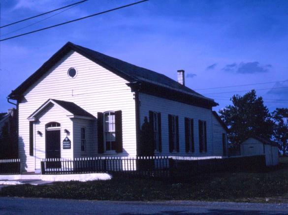
Rocky Springs School House was built in 1839. It is one of the oldest remaining one-room field-stone schools in Maryland still standing at its original location and served 90 years as a public school (1839-1930). From 1839 to 1882, it concurrently served as a public school and house of worship for the Church of the United Brethren in Christ (U.B.). The U. B. was the first Protestant denomination founded in the United States, and was organized at Rocky Springs in 1800.
On July 8, 1864, a sharp, confused fight erupted near Rocky Springs School House when about 400 of Confederate Major Harry Gilmor's men, 1st and 2nd Maryland Cavalry, unexpectedly encountered Union Captain John V. Morris's 100 men of Company M, 8th Illinois Cavalry, who were riding up the road to reconnoiter. Morris and his men fought gallantly but were forced back by superior numbers. Sergeant Harrison Hakes, Company B, 8th Illinois Cavalry, observed what was happening and hid himself and several of his men in the timber along the road in front of the school, and opened fire on the Confederate horsemen as they came rushing on. This halted the charge and gained valuable time for Company M to retreat toward the City of Frederick. Surgeon Abner Hard, 8th Illinois Cavalry, reported “... Captain Morris was killed, having received a shot in his hip, from which he died in about an hour and a half. He remained conscious to the last, and died without a murmur, as he had fought without fear.” Three of Morris' men were also wounded in the skirmish.
Gilmor wrote of the encounter, “...I came upon them rather unexpectedly, and got them at a disadvantage, and, although they sustained their reputation, we whipped them handsomely, but ran them rather too far, for we found ourselves among a line of infantry, where we lost twelve horses, with four men wounded, but none killed...Captain James L. Clark, of Baltimore, behaved nobly. A bullet struck his jacket button, and made it concave, but inflicted no injury. His horse was killed by four or five bullets. He was one of my pets after that, for he was a perfect tiger in a fight. Kemp had his horse also shot under him.” The Battle of Monocacy was fought the next day, about 8 miles southeast of the school.
Documentation of the skirmish to include two maps depicting Rocky Springs School House are in the 1898 book, Early's Great Raid, He Advances Through Maryland, Battle of Monocacy by Frederick native E. Y. Goldsborough, 1st lieutenant and aide-de-camp to Gen. Erastus. B. Tyler during the Battle of Monocacy. In 2018, Historic Rocky Springs Chapel, Inc. (HRSC), the nonprofit organization that owns Rocky Springs School House, had a Civil War Trails marker placed next to the school to interpret the skirmish for the public. Moreover, HRSC conducts Civil War style church services once each month in Rocky Springs Chapel, which is located immediately next door to Rocky Springs School House.
Please do not enter the church or the school house. This cache has been approved by the property owners.
Thanks to the following members of the Maryland Geocaching Society in placing the hides for this Geotrail Refresh: deepdish23, hunterKat, lpyankeefan, and tazscouter.