The Heart of the Civil War Heritage Area Geotrail
Williamsport

You're invited to take a journey through the Maryland's Heart of the Civil War.
The Heart of the Civil War Heritage Area Geotrail was first launched in the fall of 2016 with geocaches hidden within Maryland's Carroll, Frederick, and Washington Counties. In the spring of 2021, the Geotrail was updated with five additional geocaches and an Adventure Lab.
The Heart of the Civil War Heritage Area (HCWHA) is an area rich in history, covering portions of Maryland’s Carroll, Frederick and Washington Counties. It is located just below the Mason-Dixon Line, generally viewed as the dividing line between North and South, and above the Potomac River. With one foot in the north, and one foot in the south, the story of the Civil War can be told nowhere better than in this part of Maryland.
Between 1861 and 1865, the Civil War impacted every Maryland resident, many directly as a result of the war that was waged within the state’s borders. Some families faced financial ruin after troops ravaged their land. Thousands of fathers, sons and brothers became casualties of war. For enslaved Marylanders, the conflict ultimately brought about freedom as the new state constitution of November 1864 abolished slavery.
This region witnessed three major military movements during the Civil War: the Maryland (also known as Antietam) Campaign in the fall of 1862, the Gettysburg Campaign in the summer of 1863, and the march to Washington led by Jubal Early in the summer of 1864.Geocachers can visit significant sites from each of these three operations on the Heart of the Civil War GeoTrail.
The mission of the Heart of the Civil War Heritage Area is to promote the stewardship of our historic, cultural, and natural Civil War resources; encourage superior visitor experiences; and stimulate tourism, economic prosperity, and educational development, thereby improving the quality of life in our community for the benefit of both residents and visitors.
Geocachers who find the locations of at least 13 HCWHA caches are eligible for a free prize and may purchase a Geocoin (while supplies last of both). To record and redeem the finds, Geocachers must download a passport from the Heart of the Civil War website and record the code word from at least 13 HCWHA geocaches. Geocachers may have their passports validated in person at the Newcomer House at Antietam National Battlefield or at the Visitor Centers in Westminster or Frederick. See the Heart of the Civil War Heritage Area’s website for details on Geocoin and free prize availability.
Participating in the HCWHA geotrail is fun and we hope that many people join in. However, it is not a requirement for logging your find on this cache once you find the container.
Williamsport, now home to the headquarters of the Chesapeake & Ohio (C&O) Canal National Historical Park, has long been a vibrant spot along the Potomac River. Several Native American groups traversed the area regularly, long before white occupation. In 1727, the area’s first European settler, Israel Friend, received land from the Five Nations Tribes. The local Revolutionary War Hero, Brigadier General Otho Holland Williams, envisioned a grand city with potential to be the nation's capital; indeed, President George Washington visited in October 1794 to consider Williamsport for that purpose.
During the Civil War, Williamsport’s location along the Potomac River and Conococheague Creek made it an inevitable crossroads for troops from both sides. In June 1861, General Abner Doubleday erected a breastwork of cannons in Williamsport, overlooking the Potomac and the C&O Canal. The original cannons are restored and may be visited at Doubleday Hill. General Robert E. Lee crossed at Williamsport on his way to Gettysburg. After the Battle at Gettysburg, Lee’s army Retreated through Williamsport but was prevented from crossing into Virginia due to the heavy rains and remained in Williamsport for several days with over 400 wagons of wounded. Every church and most buildings were used as hospitals, battles were held while they were stranded in Williamsport. Personal property of local citizens was seized by both armies and divided loyalties flared.
Both the C&O Canal and the Baltimore & Ohio Railroad influenced the development of Williamsport, but the rail’s greater speed and capacity, outpaced the canal, which was best suited for transport of commodities, like lumber, wheat and especially coal. Nevertheless, the canal operated until 1924 when a damaging flood destroyed it beyond repair. People continued to live in cabins and shanties along the canal for another 45 years, until the national park was established in 1971.
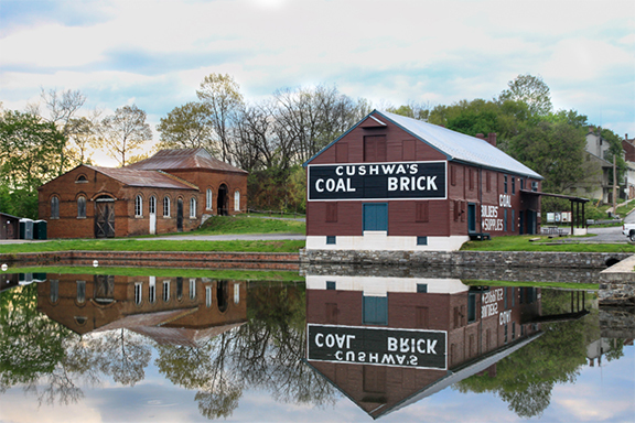
2021 is the park’s 50th anniversary! But anytime is a great time to visit the park and the ten canal towns adjacent to the towpath. At Williamsport, visitors can see the remains of the working canal – Lock 44, Lock House 44, Bollman Bridge, Lift Bridge, Turning Basin at Cushwa, and the restored and re-watered Conococheague Aqueduct. Hiking, biking, and excursions on a 1920's- style canal launch boat may be experienced here. Take time to explore the Town and enjoy a local eatery while in Williamsport.
The Geocache
This geocache is an on-site puzzle cache. At the given coordinates, [N 39° 35.949 W 077° 49.568], you will find a historical marker. There is parking nearby. Use the sign to gather information to find the final coordinates to the geocache..
Stage 1
- A = # of letters in the item that Confederates tour out the four corners of. Word begins with letter 'A'.
- B = Sum of the two DAM numbers from the 2nd paragraph.
- C = The first DAM number in the 2nd paragraph.
Find the photo that shows a canal boat passing by Williamsport as the Union troops prepare to cross the Potomac River. What year did this photo appear in Frank Leslie's Illustrated Newspaper?
- X = 3rd digit in this date.
- Y = 2nd digit in this date.
- Z = 4th digit in this date.
The coordinates for the geocache are N39° 35.ABC, W77° 49.XYZ. The checksum of A+B+C+X+Y+Z is 38. The cache is a clear lock-n-lock container. You can walk to the final from Stage 1.

Thanks to the following members of the Maryland Geocaching Society in placing the hides for this Geotrail Refresh: deepdish23, hunterKat, lpyankeefan, and tazscouter.