I started to call this Earthcache "This isn't Gneiss so Don't Take it for Granite, But You Don't Know Schist" - something like that. But those punny names are a dime a dozen.
You can park at the posted coordinates, but please pull as far off the road (southbound) as possible. This highway can be busy at times! Here you will find the exposed face of a roughly 200 square meter outcropping of the Llano Uplift.
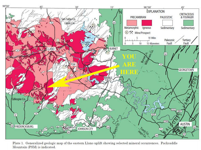
The Llano Uplift is a hallmark of the Texas Hill Country’s geology. This feature literally stands out from the surrounding area as its granite rises higher than other parts of the Hill Country. The rocks of the Llano Uplift come from the Precambrian era, which predates even the oldest dinosaurs. Most geologic time fits into the extended Precambrian, which lasted from 4.6 billion years ago to 541 million years ago. But the Llano Uplift does not extend throughout this time. The oldest parts of the area only date to 1.5 billion years ago. And this corresponds to a time when multicellular life reigned in the seas but land animals did not yet exist. Though its name suggests the land pushed upward, the exact opposite happened to expose the Llano Uplift. When the surrounding area of younger sedimentary rocks eroded away, it left behind granite at the heart of the uplift. Along with the rest of the Texas Hill Country, the Llano Uplift also rose in elevation during the Cenozoic when the Balcones Fault shifted, lifting the area to the west.
This particular outcropping is part of the Legion Creek Pluton of Town Mountain Granite.
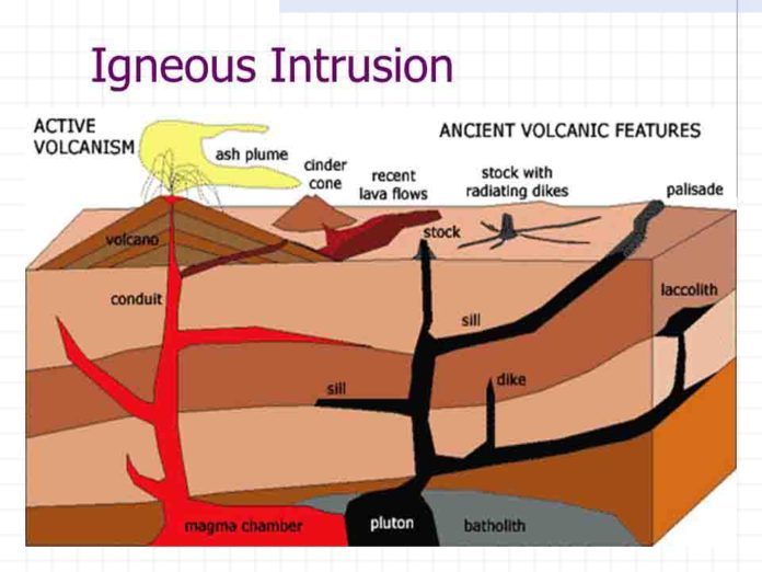
Granite is an igneous rock. Igneous rock is formed when hot magma or lava cools. This type of rock can occur in one of two forms: intrusive or extrusive. Volcanic rocks (rocks that exit volcanoes in a liquid state and cool to solidify at the Earth’s surface) are extrusive rocks. These rocks come out of the Earth--they are extruded from the earth. Granite is an intrusive rock; it forms far beneath the earth’s surface. Beneath the surface, magma is slowly pushed up and fills any crack or space it can find, sometimes pushing other rocks out of its way on the subsurface. This process can take millions of years to complete. During this time, the rock slowly cools and solidifies into a hard rock. Many mountain ranges throughout the world are formed by this kind of intrusive rock.
Granite is made of crystals. These crystals can easily be seen with the naked eye, unlike lava rocks. Even though lava rocks and granite are made essentially through the same process, speed is the important factor here. In lava rocks, the crystals are too tiny to be seen with the naked eye because the rock cooled too quickly for the crystals to grow very large. Granite, on the other hand, cooled slowly underground. The rock surrounding it shielded the granite and allowed the heat to escape slowly. This gave the crystals time to grow. Granite is generally comprised of feldspar, quartz, and small traces of other minerals. The feldspar and quartz give granite its texture. The distinct pink color of the granite is due to the alkali feldspar.
Town Mountain Granite is a coarse-grained, pink, quartz-plagioclase-microcline rock, in part porphyritic with large microcline phenocrysts. It occurs in plutons up to 13 miles in size that tend to be concordant circular vertical cylinders with concentric textural variations; boundaries range from sharp and regular to highly irregular with wide zones of mixed rock. It makes up the Enchanted Rock granite mass and underlies large portions of Gillespie and Llano Counties.
This particular outcropping is interesting because it contains an Igneous Intrusion - a slice of fine-grained solidified magma that pierces the surrounding wall rocks of pink granite. Even more interesting is that it's an igneous intrusion into igneous rock!
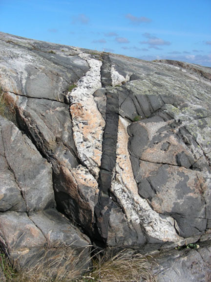
Here's a picture of an Australian intrusion in an intrusion!
Find the intrusion at the posted coordinates, near the south end of the exposed outcrop. It is fairly narrow and runs across the exposed face of the granite "wall" bottom to top from left to right as you face it from the roadside. To be certain you are looking at the correct feature, look for a brass tag with the GC code stamped on it afixed to the rock.
Sheet-like intrusions are called Dikes and thin ones tend to be fine-grained because the intruded material cooled rapidly. The shade of the intrusion in indicative of the silica content, with lighter colored rocks being silica-rich and dark material having a low concentration of silica. Low silica-content intrusions are labeled as "Mafic" intrusions. Interestingly, most intrusions are near vertical as the generally lower density of the intruded magma causes it to well up towards the earth's surface through faults and fissures in the surrounding local rocks. This particular intrusion is closer to horizontal, indicating it originated as a sill (horizontal intrusion), or probable tilting or folding of the dike in the rock layers over time.
In order to count this Earthcache as a find, you must complete the following tasks and email or message the answers to me:
1. Describe the area at ground zero.
2. Describe the color and texture of the granite. What does the color tell you about the amount of feldspar present?
3. Look at the intrusion:
- Compare the size of the crystals in the intrusion to the ones in the surrounding pink granite.
- Based on the color, would you say this is a Mafic intrusion?
- Measure (or estimate) the average width of the intrusion. Is it thicker towards the top or the bottom?
- What's the approximate tilt angle in degrees from horizontal? (your phone probably has a handy app for this).
NOT A LOGGING REQUIREMENT: Feel free to post pictures of you or your group at the area. Please don't include any spoilers in you pictures!
One set of answers sent in per group is fine, just indicate in the message all of the geocachers in your group.
DON'T INCLUDE ANY ANSWERS IN YOUR ONLINE LOG!
Sources:
https://texashillcountry.com/llano-uplift-texas-hill-country
U.S. Geological Survey, Mineral resources on-line spatial data, 2015.
Geological Society of America Centennial Field Guide - South Central Section, 1988
https://australian.museum/learn/minerals/shaping-earth/igneous-intrusions/
https://www.geologypage.com/2018/10/what-is-a-plutonic-igneous-rock.html
Roadside Geology of Texas, pages 153-154 (Darwin Spearing, 1991)
This cache created by a Platinum Earthcache Master
See Earthcache.org for more info on how to become an Earthcache Master.
Congratulations to Team Troglodyte for being FTF!