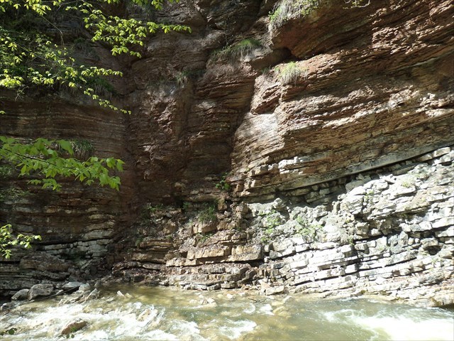
Kalksteinschichten in der Glasenbachklamm

Im Erdmittelalter (Mesozoikum) dehnte sich zwischen Afrika und Europa das Thetysmeer aus. Auf dem Meeresboden entstanden über Millionen von Jahren hinweg aus Kalkschlamm mehrere Kilometer dicke Schichten von Kalkgestein.
Roter Knollenkalk oder Knotenkalk, der durch seine farbige Ausprägung auffällt, entstand durch wechselnd rasche Ablagerung von Kalkschlamm im Meer. Wurde in kurzer Zeit viel Kalkschlamm abgelagert, konnte daraus Kalkgestein entstehen. Wurde hingegen nur wenig Kalkschlamm abgelagert, löste das Meerwasser den Kalk teilweise wieder auf und es blieben nur Knollen von unlöslichem Material (Tonmineralien) übrig. Diese Tonminerallagen umschließen im Gestein die Karbonatablagerungen und sind für den optischen Eindruck des Gesteins typisch. Die Färbung des roten Knollenkalks wird durch das Eisenmineral Hämatit (Roteisenstein) bewirkt. Wegen seines strukturell wechselhaften und farbig lebendigen Erscheinungsbildes wurde Knollenkalk zu architektonischen und bildhauerischen Zwecken verwendet, unter anderem für zahlreiche Kirchen- und Profanbauten sowie Grabdenkmäler. Oft kann man in Knollenkalken auch Fossilien des Erdmittelalters entdecken.
Die grauen Hornsteinknollenkalke darunter sind deutlich mächtiger und enthalten Lagen von dunkelgrauen Hornsteinen. Hornsteine bestehen aus Kieselsäure und wurden wegen ihrer Härte ebenso wie der Radiolarit, den man hier in der Schlucht finden kann, in der Steinzeit zur Herstellung von Werkzeugen verwendet. So wie andere Werkzeugsteine spaltet Hornstein mit dem für Quarz typischen muscheligen Bruch und bildet scharfe Kanten aus, die als Schaber oder Messer verwendet werden konnten. Die Entstehungszeit der vorliegenden Schichten liegt im unteren Jura vor etwa 200 Millionen Jahren.
Hornsteinknollen sind ein silikatreiches Sedimentgestein biogener, chemisch-biogener oder chemischer Genese. Die Struktur von Hornstein ist sehr feinkörnig, durch die Verunreinigung mit Tonmineralien ist er nicht so gut spaltbar wie der mineralogisch ähnliche Feuerstein. Gewöhnlicher Hornstein bildet sich wie Feuerstein in Kalksteinen als ovale bis unregelmäßig geformte Knollen oder auch in unregelmäßigen Platten infolge der Verdrängung von Kalziumkarbonat durch Siliziumdioxid (Quarz), oft auch durch Verkieselung von Pflanzenmaterial.
Vor Ort kann man nicht nur beide Kalksteinschichten gut aufgeschlossen betrachten, man sieht auch eine geologische Besonderheit, die Teil der Fragen zum Earthcache ist.

In the Mesozoic Era, the Thetys Sea expanded between Africa and Europe. Over millions of years, layers of limestone several kilometers thick were formed from lime sludge on the sea floor.
The red knot limestone (tuber lime), which is noticeable due to its colour, was created by the alternately rapid deposition of lime sludge in the sea. If a lot of lime sludge was deposited in a short time, limestone could arise from it. If, on the other hand, only a small amount of lime sludge was deposited, the sea water partially dissolved the lime again and only nodules of insoluble material (clay minerals) remained. These clay mineral layers enclose the carbonate deposits in the rock and are typical for the visual impression of the rock. The colour of the red knot limestone is caused by the iron mineral haematite (bloodstone). Because of its structurally changeable and colourful appearance, tuber lime was used for architectural and sculptural purposes, including for numerous church and secular buildings as well as grave monuments. Often one can also discover fossils from the Mesozoic Era in tuber lime.
The grey chert limestone below is much thicker and contains layers of dark grey chert. Chert are made of silica and because of their hardness, like the radiolarite that can be found here in the gorge, were used to make tools in the Stone Age. Like other tool stones, chert splits with the shell-like break that is typical of quartz and forms sharp edges that could be used as scrapers or knives. The origin of the present layers is in the lower Jurassic about 200 million years ago.
Chert nodules are sedimentary rocks rich in silicates of biogenic, chemical-biogenic or chemical origin. The structure of chert is very fine-grained, due to the contamination with clay minerals it is not as easy to split as the mineralogically similar flint. Ordinary chert forms like flint in limestone as oval to irregularly shaped tubers or in irregular plates as a result of the displacement of calcium carbonate by silicon dioxide (quartz), often also by silicification of plant material.
On site you can not only look at both limestone layers in an open-minded manner, you also see a geological peculiarity that is part of the questions about the Earthcache.
Deine Aufgaben zum Loggen dieses Earthcache / Your task to log this Earthcache:
Schicke mir die Antworten auf folgende Fragen per Message über mein Profil:
Send me your answers to the following questions via message:
1.) Vergleiche die beiden übereinander gelagerten Kalksteinschichten, den roten Knollenkalk und den grauen Hornsteinkalk (Farbe, Struktur, Beschaffenheit...)!
Compare the two superimposed limestone layers, the red knot limestone and the grey chert limestone (colour, structure, texture...)!
2.) Schätze die Mächtigkeit der Schichten des roten Knollenkalks und des grauen Hornsteinkalks vor Ort!
Appreciate the thickness of the layers of the red knot limestone and the grey chert limestone on site!
3.) Welche Fossilien kann man hier im roten Knollenkalk finden?
Which fossils can be found here in the red knot limestone?
4.) Welche geologische Besonderheit sieht man hier in der Wand auf der gegenüberliegenden Bachseite, etwa in der Mitte? Beschreibe die Situation mit eigenen Worten!
What geological peculiarity can you see here in the wall on the opposite side of the stream, roughly in the middle? Describe the situation in your own words!
5.) Optional: Gerne kannst du ein Foto von dir und/oder deinem GPS vor Ort dem Log hinzufügen!
Optional: If you like you can add a picture of you and/or your GPS unit at the location to your log entry!
Du brauchst nicht auf eine Logfreigabe zu warten! Sobald die Antworten abgeschickt sind, kannst du loggen! Ich melde mich bei dir, falls irgendetwas nicht passt.
There is no need to wait for a log permission! You can log immediately after you sent me your answers! If there's something wrong, I'll contact you.
Viel Freude beim Erkunden der Location! Have fun and enjoy the location!
Quellen / Sources:
Informationstafeln vor Ort
Stow, Dorrik A.V. (2008): Sedimentgesteine im Gelände. Ein illustrierter Leitfaden.
Vinx, R. (2011): Gesteinsbestimmung im Gelände.
wikipedia.org.
Die Fotos stammen vom Verfasser / The pictures were taken by the author.
 The most exciting way to learn about the Earth and its processes is to get into the outdoors and experience it first-hand. Visiting an Earthcache is a great outdoor activity the whole family can enjoy. An Earthcache is a special place that people can visit to learn about a unique geoscience feature or aspect of our Earth. Earthcaches include a set of educational notes and the details about where to find the location (latitude and longitude). Visitors to Earthcaches can see how our planet has been shaped by geological processes, how we manage the resources and how scientists gather evidence to learn about the Earth. To find out more click HERE.