ITALIANO
Il Lastron dei Scarperi e' fra le montagne piu' alte del gruppo di Sesto, ma allo stesso tempo e' anche una delle (relativamente) piu' accessibili. Tuttavia, vista la maggior lontananza e dislivello, e' anche una cima meno frequentata, rispetto alle zone piu' note del Parco Naturale delle Tre Cime.
L'ambiente e' grandioso, e offre delle viste magnifiche e un po' diverse su tutto il Parco, sulle Marmarole e il Sorapis, il Cristallo, le Tofane, e a Nord sulla val Pusteria e il gruppo di Ries, e a Est sulla dorsale che divide Italia e Austria.
I possibili avvicinamenti
La salita e' molto impegnativa, da qualsiasi parte la si affronti.
Rifugio Auronzo
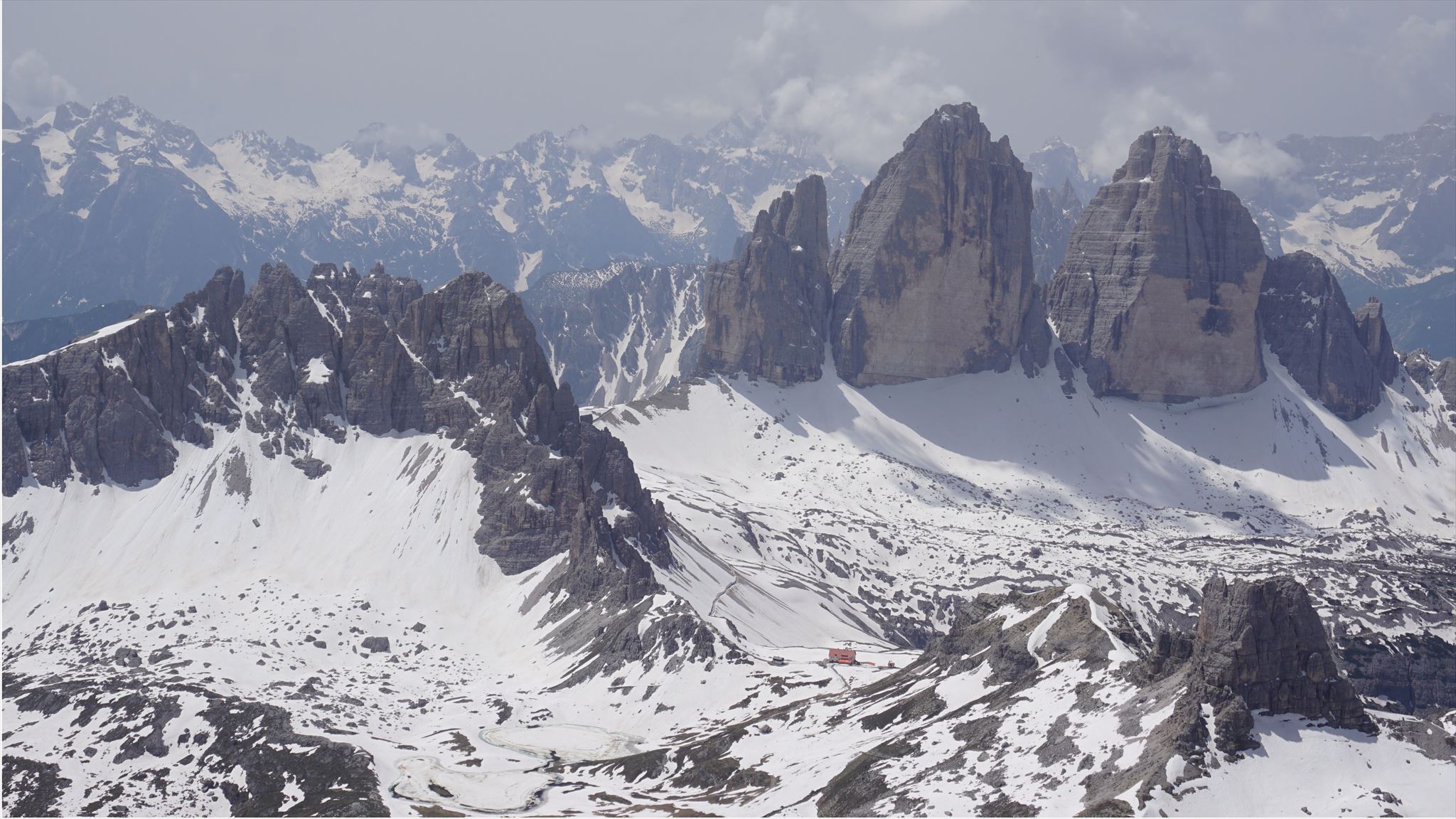
La salita piu' agevole, per i minori metri di dislivello, e' dal Rifugio Auronzo (2333m): dalla localita' Antorno, nei pressi di Misurina, si puo' salire in macchina o in autobus fino al rifugio. Arrivati al rifugio Auronzo, si circumnavigano le Tre Cime di Lavaredo (lato Sud leggermente piu' lungo, oppure lato Nord), rimanendo piuttosto in quota, e si arriva al rifugio Locatelli (2450m).
Costo (2020):
- parcheggio al waypoint 03: 30 euro a macchina
- parcheggio gratis al waypoint 04
- autobus da Misurina o da waypoint 04: 4 euro a persona a tratta
Val Fiscalina
L'accesso da Val Fiscalina (1450m) e' senza dubbio piu' lungo e faticoso (da qui in totale ci sono 1500m circa di dislivello). Tuttavia non ci permette di assaporare la magnifica val Fiscalina prima, su cui sovrastano punta Tre Scarperi e la Croda Rossa e, piu' lontane, cima Undici, il Popera e la Croda dei Toni, e la val Sassovecchio poi, con la cima Una e Croda Fiscalina a sinistra salendo, e il Lastron dei Scarperi stesso a destra. Dulcis in fundo, le due cascate prima di arrivare al pianoro finale.
Partendo da waypoint 2, dopo una breve e facile passeggiata si arriva al rifugio Fondovalle. Tenendosi a destra, si prosegue ancora pochi minuti fino ad un bivio dove e' esposta una mappa della zona. Proseguire a destra verso il rifugio Locatelli. Qua il sentiero prosegue senza poter sbagliare, fino al Locatelli.
Costo (2020):
- parcheggio al waypoint 01: 8euro
- parcheggio al waypoint 02: gratis
Val Campo di dentro
Si puo' salire anche dalla Val Campo di Dentro, passando per il rifugio Tre Scarperi.
La salita
Dal Locatelli, scendere per duecento metri circa verso N, e prendere il sentiero che si dirige verso l'ampia Sella San Candido a N. Dalla sella, salire lungo il sentiero verso E, per poi in breve arrivare alla Selletta Bassa (waypoint R0). Da qui comincia l'avventura. Si scavalca la sella tenendosi accostati alla parete E. Dirigendosi verso NE, perdendo prima un po' di quota, si attraversa il ghiaione, seguendo il sentiero. Attraversato il ghiaione, si comincia a salire (verso N) e, a volte intuitivamente, si sale verso la conca. Dalla conca si continua a salire verso NO, per poi puntare verso un canalone piuttosto ripido e stretto. Superato il canalone, il sentiero si appiana man mano fino ad arrivare in vetta (1h 30m/2h dalla forcella San Candido).
ENGLISH
Lastron dei Scarperi is one of the highest mountains in the Sesto group, but at the same time it is also one of the (relatively) most accessible. However, given the greater distance and the longer climb, it is also a less frequented peak, compared to the more famous areas of the Tre Cime Natural Park.
The environment is grandiose, and offers magnificent and slightly different views over the whole park, over the Marmarole and the Sorapis, the Cristallo, the Tofane, and to the north over the Val Pusteria and the Ries group, and to the east on the ridge that divides Italy and Austria.
Possible approaches
The climb is very demanding, wherever you face it.
Auronzo Refuge
The easiest climb, due to the lower altitude difference, is from the Auronzo Refuge (2333m): from Antorno, near Misurina, you can go up by car or bus to the refuge. Arriving at the Auronzo refuge, you circumnavigate the Tre Cime di Lavaredo (slightly longer south side), remaining rather at the same altitude, and you will arrive at the Locatelli refuge (2450m).
Cost (2020):
- parking at waypoint 03: 30 euros per car
- free parking at waypoint 04
- bus from Misurina or from waypoint 04: 4 euros per person each way
Val Fiscalina
Access from Val Fiscalina (1450m) is undoubtedly longer and more tiring (from here in total there are about 1500m of altitude difference). However, it does not allow us to savor the magnificent Val Fiscalina first, on which Punta Tre Scarperi and the Croda Rossa dominate and, further away, the Undici peak, the Popera and the Croda dei Toni, and the Sassovecchio valley then, with the Una and Croda Fiscalina on the left going up, and the Lastron dei Scarperi itself on the right. Last but not least, the two waterfalls before reaching the final plateau.
Starting from waypoint 2, after a short and easy walk you will arrive at the Fondovalle refuge. Keeping to the right, continue for a few more minutes until you reach a crossroads where a map of the area is displayed. Continue to the right towards the Locatelli refuge. Here the path continues without being able to make mistakes, up to Locatelli.
Cost (2020):
- parking at waypoint 01: 8 euro
- parking at waypoint 02: free
Val Campo di Dentro
You can also go up from Val Campo di Dentro, passing through the Tre Scarperi refuge.
The climb
From Locatelli, go down for about two hundred meters N, and take the path that heads towards the wide Sella San Candido. From the saddle, go up along the path towards E, and then quickly arrive at the Lower Saddle (waypoint R0) . This is where the adventure begins. Climb over the saddle keeping close to the E wall. Heading NE, first losing some altitude, cross the scree, following the path. After crossing the scree, you begin to climb up (towards N) and, sometimes intuitively, you go up towards the basin. From the basin the climb continues NW, and then it head towards a rather steep and narrow gully. Once past the gully, the path gradually flattens out until it reaches the summit (1h 30m / 2h from the Sella San Candido).
Attenzione! Disclaimer
Climb at your own risk! Hike is about 20 km long: please do not try this hike without any previous mountaineering experience!
Bring a helmet with you to protect you from falling rocks. Stay safe and have fun!
There is room for trackables!