This is an Earthcache highlighting Glacial Lake Wisconsiin
This Earthcache takes you on a short hike on the Camel Bluff trail in Mill Bluff State Park. To complete the Earthcache, park at the designated coordinates on County Highway W, and make the loop hike on the trail. The trail is a loop which encircles Camel Bluff, with a spur to another rock formation. You will want to take a very nice walk on the loop, and get a picture at the rock formation at the end of the spur. This is a mostly flat walk on a well managed State Park trail. The terrain is mostly 1.5 for the entire length, but I gave it a 2.5 for the short climb to the rock formation.
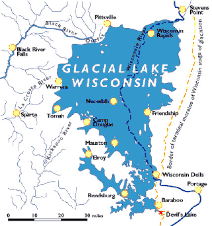
Glacial Lake Wisconsin was a short-lived prehistoric glacial lake that existed from approximately 19,000 to 15,000 years ago, at the end of the last Wisconsin ice age. The lake was located in the "central sand plains" ecoregion of the state. This portion of the state is generally a flat, sandy lake plain which was formed in and around Glacial Lake Wisconsin. The soil here is primarily sandy lake deposits. Sandstone buttes carved by rapid drainage of the glacial lake, or by wave action when they existed as islands in the lake, are distinctive features of this landscape.
The lake began its formation when ice from the Green Bay Glacial Lobe came into contact with the Baraboo Hills in southwestern Wisconsin. This contact blocked the south-flowing Wisconsin River and due to higher topography on the lakes other margins it continued to fill fed by meltwater from the Wisconsin River. At its peak Glacial Lake Wisconsin was up to 150 feet in deep and covered over 1,825 square miles. Today lake deposits are covered in many places by glacial outwash, dune sand, peat and muck. Many of the swamps, marshes and bogs of central Wisconsin were formed as a result of the accumulation of the Lake's more impervious deposits after the last glaciation.
Even though this park is in the driftless region, the area the glaciers missed, the geologic features are partially the result of the last stage of glaciation. During this glacial advance, the Wisconsin River was plugged near Wisconsin Dells. The river spread out to form glacial Lake Wisconsin, covering most of what today are Adams, Juneau and other adjacent counties, including the Mill Bluff area. During this time, some of the mesa and buttes stood as islands in the glacial lake, while others were submerged. Wave action hastened erosion of the sides of the rock forms.
The unique flat-topped, cliff-sided rock structures are capped by layers of somewhat more resistant sandstone; and weathering tends to break the rock off in vertical fragments. There are remnants of the Dresbach Group, Upper Cambrian sandstone. The heights of the bluffs range from 80 feet to over 200 feet. The mesa and buttes are isolated "outliers" of the continuous limestone-capped escarpments south of the park.
Rocks and boulders of different compositions than local bedrock are erractics. They have been found on the sides of some of the buttes and mesas. These erractics are boulders that were embedded in icebergs that floated and lodged against the mesa and buttes. When the ice melted, the boulders remained lodged on the sandy flanks of the bluffs.
Erosion by wind and water eventually wear away the underlying soft sandstone until the weight of the overhanging cap rock causes it to shatter and fall. The mounds will decrease in size until all the capping is removed. Then the mound becomes a conical hill, gradually blending into the plain.
These unique glacial features are protected in Mill Bluff State Park, one of nine units of the Ice Age National Scientific Reserves. Because of the uniqueness of this park and of the delicate sandstone structures of the buttes, climbing on or defacing the bluffs is strictly prohibited. Anyone who disobeys this rule will have to pay a fine.
This Earthcache takes you on a short hike on the Camel Bluff trail in Mill Bluff State Park. To complete the Earthcache, park at the designated coordinates on County Highway W, and make the loop hike on the trail. The trail is a loop, with a spur to a rock formation. You will want to take a very nice walk on the loop, and get a picture at the rock formation at the end of the spur.
As you walk around the loop take notice of the color of the soil, and look towards the bluff, which is mostly obscured by trees, and not very visible during the summer.
At waypoint 3 (N 43° 57.163' W 90° 18.795') you will find a short spur trail towards the bluff. Take this short spur trail to the posted coords and get a picture at the posted coords.
At waypoint 2 (N 43° 57.332' W 90° 18.838') look toward the bluff which is the best place on the loop to see the top of the bluff.
Large bluffs are called mesas. Smaller, more abrupt bluffs are called buttes and other more slender, abrupt bluffs are called pinnacles. You can see examples of all three at Mill Bluff State Park
Send me the answer to these questions:
1. Is the rock formation at Ground Zero a mesa, a butte or a pinnacle?
2. In many places along the trail the trail has been worn down so that you can see the soil. What color is the soil, and why do you think that is?
3. Give me an estimate of the height of Camel Bluff.
4. Please describe how Camel Bluff was formed in your own words.
5. Please post a picture of you or your gpsR at Ground Zero with the smaller rock formation that you see there.
Please note that this cache is in a State Natural Area, and special permission was received from thomas.meyer@wisconsin.gov to place an Earthcache at this location. Please stay on the trail.
In addition, The Geocache Notification Form has been submitted to the Wisconsin DNR. Geocaches placed on Wisconsin Department of Natural Resource managed lands require permission by means of a notification form. Please print out a paper copy of the notification form, fill in all required information, then submit it to the land manager. The DNR Notification form and land manager information can be obtained at: http://dnr.wi.gov/files/PDF/forms/2500/2500-118.pdf