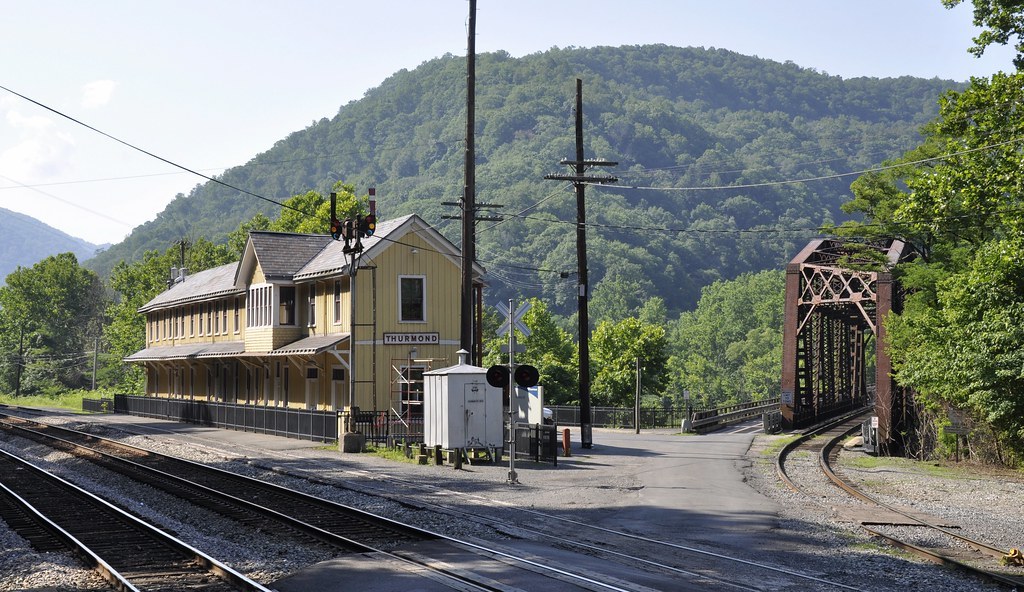
Thurmond is a present day ghost town with a population of 5 located within the New River Gorge. The town was once a boomtown and with the huge amounts of coal brought in from surrounding mines, it had the largest revenue on the Chesapeake and Ohio Railroad. At its peak, 15 passenger trains stopped here each day, serving 95,000 passengers a day. Thurmond had two hotels, two banks, restaurants, clothing stores, a jewelry store, movie theater, several dry-good stores, and many business offices. Once the railroads began to switch from diesel to coal, combined with a declined output of coal from the surrounding mines, the town began a steady decline. Today, Amtrak trains stop here only three times a week. The town is on the National Registry of Historic Places and you walk down what were once busy streets and learn about the areas past.
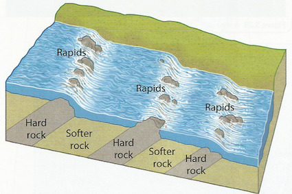
The listed coordinates will bring you to a spot outside what was once the train station that overlooks the New River. If you would like to get a better view, you can walk out onto the bridge (several observation bays have been built). In the summer time you may notice lots of people rafting in the river (one of the most popular activities in the park). Rapids are kind of mix between a run (a section of smooth flowing river) and a cascade. They are formed when a river cuts downwards through a bed of hard and soft rocks. The soft rock gets eroded more easily, leaving behind the hard rocks which can be exposed above the water surface. An important thing to keep in mind is that the bedrock needs to be very resistant to the erosional power of the river, otherwise the bedrock would be eroded and the rapids would disappear over time.
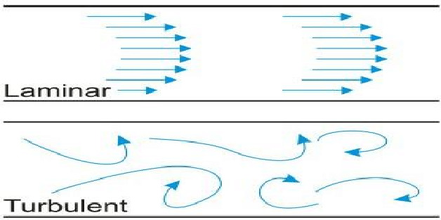
As we have learned, the underlying geology of the river bed can influence the flow of the river. It can be described as either laminar flow, or turbulent flow. Laminar flow is straight and smooth. The fluid particles pass by each other without mixing. In contrast, turbulent flow is more rough. For example if there was some driftwood floating in a turbulent flow river, it would hit some rocks, then get diverted to either side, maybe even spin around, if a camera was mounted on the front, you would see that it would not be a smooth ride.
Logging Requirements:
- Observe the section of river in front of you. In this spot, are the rapids caused by protruding sections of hard bedrock or by boulders?
- Do you think river is in laminar flow, or turbulent flow? Do you think this is affected by the water level in the river?
- Looking upstream, you may notice that there is a distinct where the rapids begin. What factors of the underlying geology may have resulted in this?
- Upload a photo taken anywhere in Thurmond. You do not need to be in the photo, though it is strongly encouraged.