A needle dam is a WEIR designed to maintain the level or flow of a river through the use of thin "needles" of wood. The needles are leaned against a solid frame and are not intended to be water-tight. Individual needles can be added or removed by hand to constrict the flow of the river, forming a sluice.

A weir or low head dam is a barrier across the width of a river that alters the flow characteristics of water and usually results in a change in the height of the river level. They are also used to control the flow of water for outlets of lakes, ponds, and reservoirs to prevent flooding, measure discharge, and help render rivers navigable. A weir is anchored in the bedrock so that no water can flow under it.
There are many weir designs ( SEE BELOW) but commonly water flows freely over the top of the weir crest before cascading down to a lower level. Weirs like this one are commonly found upstream of towns and villages and can either be automated or manually operated. By slowing the rate at which water moves downstream even slightly, a disproportionate effect can be had on the likelihood of flooding. On larger rivers, a weir can also alter the flow characteristics of the waterway to the point that vessels are able to navigate areas previously inaccessible due to extreme currents or eddies . Many larger weirs will have construction features that allow boats and river users to "shoot the weir" and navigate by passing up or down stream without having to exit the river.
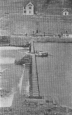
Early pictures of the WEIR dam in Louisa, Ky is pictured below

A sluice is a is a water channel controlled at its head by a gate. Sluice is a DUTCH word that means channel. A sluice gate is a gate installed in the channel to manage the flow.

As most of you cachers who know me, knows that I am a crazed history fanatic so when I came across this bit of Kentucky history I knew I had to bring others of my type here as well. With there being a traditional cache very nearby I decided to give an EarthCache a shot. I knew that seekers of such things would spot an EC from any map recon that they may conduct so here in the both the paragraphs above and below is my presentation for "Needles Dam is 'a'WEIR in Louisa Kentucky". Please BE 'a'WEIR ( Pun intended) that you can NO longer actually reach Ground Zero from either side of the Big Sandy but you do have a very clear view from the parking coordinates provided.
Across the way in WV you can see the old dam keepers house. On that side you can also see the sluice used to passage of boats going down river and controlled by the keeper. If you do a quick recon by map you can see that there is a path that leads to the house, on that side, ( no longer occupied) and to other relics of this great piece of American History.
In the small town of Louisa in Eastern Kentucky, the Big Sandy River has long been an important part of the area. In the 1800s, it was crucial to the livelihood of the people who lived there and thankfully, it was home to the first needle dam in America.
Louisa, Kentucky is located along the Big Sandy River which separates our state from West Virginia. The river has long been an important part of the community and in the 1800s was a popular route for boat transportation.The river, however, was not easily passable in some areas and so a plan for the first needle dam in America was born. The photo above of tis WEIR shows the dam as it looked when in operation. The dam aided river travel from the late 1800s until 1942 when it was deemed unnecessary. Railroad transportation was booming in Eastern Kentucky and so it was too costly to continue to operate the dam. Almost 80 years later, and you can still see evidence of the needle dam within the Big Sandy River.People used to be able to walk across the dam and it definitely served its purpose by making the river more navigable for larger vessels..

I discovered this great old photo taken from the Kentucky side.
The Big Sandy Lock and Dam #3 in Fort Gay, WV was officially completed on New Year’s Day 1897. The project also included construction of a lock house that was also completed in 1897 and is now owned by The Town of Fort Gay.
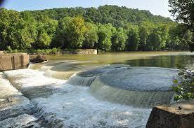
Above is todays view.
Below is are short video of of this area. If you want to view it you will need to copy and paste it in your browser.
https://youtu.be/9epC5mMSTMQ
TYPES of WEIRS:
Triangular weir:
- The shape of the weir is actually reverse triangle like V. so, it is also called V-notch weir.
- This type of weirs are well suitable for measuring discharge over small flows with greater accuracy .

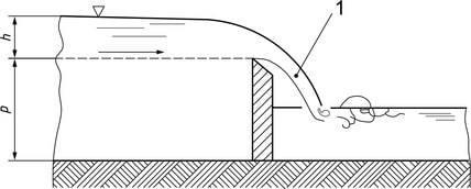
Sharp-crested weir
- The crest of the weir is very sharp such that the water will springs clear of the crest.
- The weir plate is bevelled at the crest edges to obtain necessary thickness. And weir plate should be made of smooth metal which is free from rust and nicks.
- Flow over sharp-crested weir is similar as rectangular weir

-
Broad-crested weir:
- These are constructed only in rectangular shape and are suitable for the larger flows.
- Head loss will be small in case of broad crested weir.
-
Narrow-crested weir:
- It is similar to rectangular weir with narrow shaped crest at the top.
- The discharge over narrow crested weir is similar to discharge over rectangular weir
-
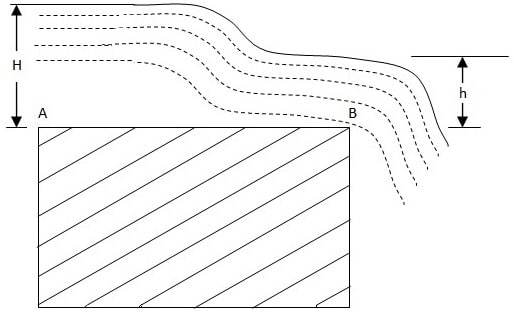
Ogee-shaped weir:
- Generally ogee shaped weirs are provided for the spillway of a storage dam.
- The crest of the ogee weir is slightly rises and falls into parabolic form.
- Flow over ogee weir is also similar to flow over rectangular weir.
In order to log this Earthcache, you must send me the answers to the following questions:
1. Based on your reading above and your observations, which type best describes the weir here that crosses the Big Sandy River?
2. Estimate the drop from the rivers top to the when the water reaches the last level.
3. The description above details several reasons why weirs are commonly built. Looking out over the area towards GZ and after your readings, which of these reasons do you think this weir was built for?
4. Observe the river before and after the weir. Do you see any evidence of erosion? If so, is the erosion better worse or the same after the weir? Explain your reasoning.
5. Choice -1 There are many relics still near the dam site. Find one, being careful of your footing ,and take a picture of it with you or your GPS on or next to it.
Choice 2 Take a picture of you or your GPS with the WEIR in in background. Feel Free to post any pictures to your log.