Update 08.02.2022: Da sich einiges verändert hat gibt es neue Bilder für C und M. D wurde bereits Ende November 21 erneuert.
Update 25.05.2022: Dieses mal gibt es für das verschwundene Bild J ein neues Bild.
Update 25.08.2022: Bild B wurde erneuert.
Update 03.02.2023: Bild I wurde erneuert.
Update 04.06.2023: Bild E wurde erneuert.
Update 25.01.2026: Bild D wurde erneuert.
Einleitung: Ich habe gerne Bildermultis und habe mir gedacht, hier in Straden kann man auch einen schönen, kurzen Bildermulti erstellen. Ich hoffe er ist nicht allzuschwer geworden. Die Weglänge beträgt ungefähr 750m.
Was ist zu tun: Eure Aufgabe ist es, bei den Headerkoordinaten (= Parkplatz) zu starten und die durcheinandergewirbelten Bilder richtig zu reihen. Spaziert entlang der rot eingezeichneten Route auf der Karte. Bringt die Bilder in die richtige Reihenfolge und ordnet den in den Bildern angegebenen Variablen (A-N) gemäß der Reihenfolge die Werte 1-14 zu. Setzt die so erhaltenen Variablen mit ihren Werten in die Formeln ein und ihr erhaltet die Endkoordinaten. Mit dem Multichecker könnt ihr die errechneten Koordinaten auf ihre Richtigkeit kontrollieren. Die Bilder sind in unterschiedlichen Abständen zu finden. Die Abbildungen der Fotos können stark vergrößert sein. Die gesuchten Bilder können links und rechts vom Weg beheimatet sein. Vielleicht lohnt sich auch ein Blick zurück.
Wegbeschreibung: Der Startpunkt ist gleichzeitig auch eine Möglichkeit euer CM zu parken. Euer Weg geht Richtung Westen über die Straße, dann die Stufen abwärts, ihr kommt bei einem Brunnen vorbei. Danach geht es rechts weiter bis ihr wieder zur Hauptstraße gelangt. Überquert diese und geht weiter Richtung Westen. Haltet euch rechts und biegt in den Sezianiweg ein. Das letzte Bild findet ihr ca. 60m bis 80m nach dem letzten Haus auf der linken Seite. Falls ihr den Sportplatz seht, dann seit ihr definitiv zu weit gegangen.
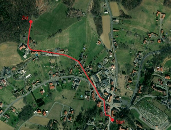
Übersichtskarte / Overview map:
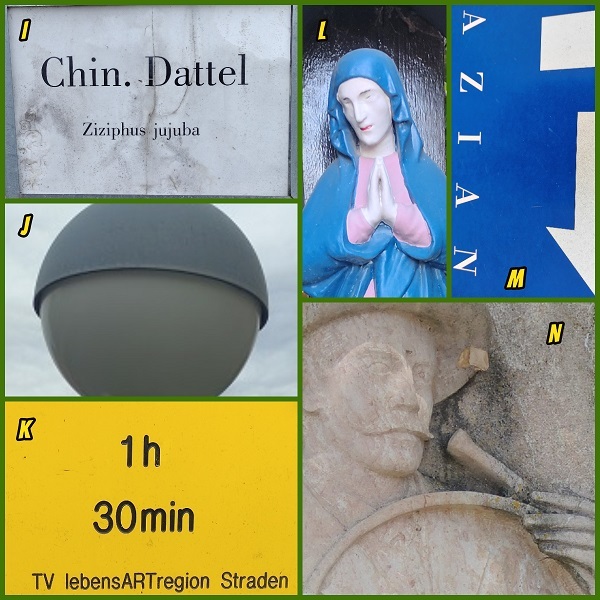
Suchbilder / Search pictures:

Formeln/ Formulas :
xxx = 2 * ( ( A * B ) + ( C * D ) + ( E * F ) + ( G * H ) + ( I * J ) + ( K * L ) + ( M * N ) ) - 28
yyy = 2 * ( ( A * B ) + ( C * D ) + ( E * F ) + ( G * H ) + ( I * J ) + ( K * L ) + ( M * N ) ) + 79
NFINAL = N46° 48.xxx
EFINAL = E015° 51.yyy

Jeder Geocacher ist für sein Tun und Handeln selbst verantwortlich!
[English]
Update 08.02.2022: Since some things have changed, there are new pictures for C and M. D was already renewed at the end of November 21.
Update 25.05.2022: This time there is a new picture for the disappeared picture J.
Update 25.08.2022: Picture B has been renewed.
Update 03.02.2023: Picture I has been renewed.
Update 03.02.2023: Picture E has been renewed.
Update 25.01.2026: Picture D has been renewed.
Introduction: I like to have picture multis and I thought, here in Straden you can also create a nice, short picture multi. I hope it is not too difficult. The path length is about 750m.
What to do: Your task is to start at the header coordinates (= parking lot) and line up the jumbled pictures correctly. Walk along the route marked in red on the map. Put the pictures in the right order and assign the values 1-14 to the variables (A-N) given in the pictures according to the order. Insert the variables with their values into the formulas and you will get the final coordinates. With the Multichecker you can check the calculated coordinates for their correctness. The images can be located at different distances. The images of the photos can be greatly enlarged. The searched pictures can be located on the left and on the right side of the path. Maybe it is worth to have a look backwards.
Directions: The starting point is also the possibility to park your CM. Your way goes west over the street, then down the steps, you pass a fountain. Then continue to the right until you reach the main road again. Cross it and continue west. Keep to the right and turn into Sezianiweg. You will find the last picture about 60m to 80m after the last house on the left side. If you see the sports field, you have definitely gone too far.
Overview map, the pictures and the formulas are above in the German text.
Every geocacher is responsible for his own actions!
Translated with www.DeepL.com/Translator (free version)