선유도는 10개의 유인도와 20여 개의 무인도로 구성되는 고군산 군도의 중심 섬이다. 북섬[선유 3구]과 남섬[선유 1구, 선유 2구]이 약 1.5㎞의 육계사주로 연결되어 1개의 섬이 되었다. 육계사주 상부에는 해안 사구가 발달하고, 동쪽에는 간석지가 형성되었다. 육계사주의 상부에는 모래 언덕인 사구가 형성되어 숲과 휴식 공간으로 이용되고 있다. 이곳에는 주로 북북서(NNW)쪽에서 바람이 부는데, 이 바람이 육계사주 형성에 영향을 주었을 것으로 판단하고 있습니다.
Seonyudo Island is the central island of the Gogunsan archipelago consisting of 10 inhabited islands and 20 uninhabited islands. The North Island and the South Island were connected by a 1.5km-long tombolo to form one island. A coastal sand dune was developed in the upper part of tombolo, and a tidal flat was formed in the east. The wind blows mainly from NNW here, and this wind is supposed to have influenced the formation of the tombolo.
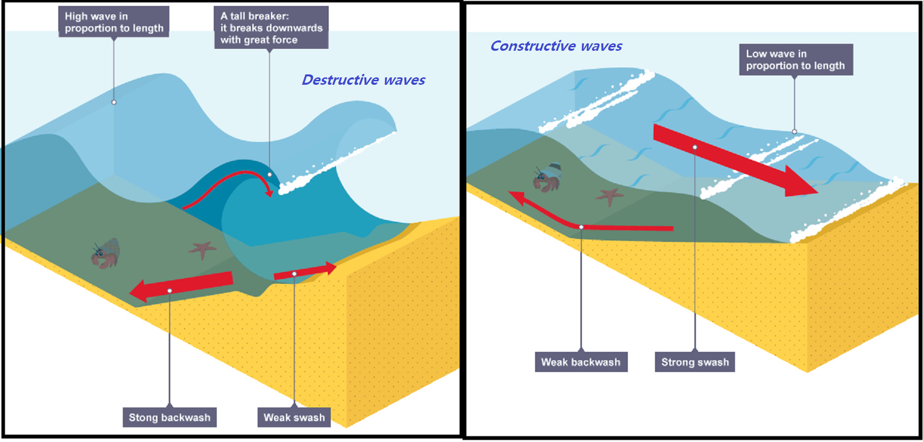
Constructive wave & Destructive wave
There are two different types of wave - constructive and destructive. They can affect the coastline in different ways. When a wave reaches the shore, the water that rushes up the beach is known as the swash. The water that flows back towards the sea is known as the backwash. The energy of the swash and backwash determine the type of wave.
The characteristics of a destructive wave are:
- weak swash and strong backwash
- the strong backwash removes sediment from the beach
- the waves are steep and close together
The characteristics of a constructive wave are:
- strong swash and weak backwash
- the strong swash brings sediments to build up the beach
- the backwash is not strong enough to remove the sediment
- the waves are low and further apart
건설적 & 파괴적 파도
파도에는 건설적인 것과 파괴적인 것의 두가지 유형이 있습니다. 그들은 다른 방식으로 해안선에 영향을 미칠 수 있습니다. 파도가 해안에 도달하면 해변 위로 밀려오는 물을 Swash라고합니다. 바다로 다시 흐르는 물을 Backwash라고합니다. Swash와 Backwash의 에너지는 파도의 유형을 결정합니다.
파괴적인 파도의 특성 :
- 약한 Swash와 강한 Backwash
- 강한 Backwash로 해변의 침전물을 깊은 바다로 끌고 들어간다.
- 파도의 경사가 가파르고 파도간의 간격이 서로 가깝다.
건설적인 파도의 특성 :
- 강한 Swash와 약한 Backwash
- 강한 Swash는 해변이 만들어지는 퇴적물을 가져온다.
- Backwash은 침전물을 깊은 바다로 끌고갈만큼 충분히 강하지 않다.
- 파도는 낮고 파도간의 간격은 멀리 떨어져 있다.
Transportation
Sediment is carried by the waves along the coastline. The movement of the material is known as longshore drift. Waves approach the coast at an angle because of the direction of prevailing wind. The swash will carry the material towards the beach at an angle. The backwash then flows back to the sea, down the slope of the beach. The process repeats itself along the coast in the zigzag movement.

퇴적물의 이동
퇴적물은 해안선을 따라 파도에 의해 운반됩니다. 물질의 이동을 연안류(Longshore drift)라고합니다. 바람의 방향에 따라 파도가 비스듬히 해안으로 접근합니다. Swash는 해변을 향해 비스듬히 퇴적물들을 운반합니다. 그런 다음 Backwash는 해변의 경사면을 따라 바다로 다시 흐릅니다. 이 과정은 지그재그 운동으로 해안을 따라 반복됩니다.
Deposition.
The diagram shows the building of a spit by longshore drift across the mouth of a river.
Sandspits often have a curved or hooked end as a secondary wind and wave direction curves the end of the spit as waves strike from this second and different direction. A series of such hooks can develop over time.
The spit creates an area of calmer water, sheltered by the spit. A lagoon, salt marsh and finally dry land can develop in this sheltered area.
(Bar)
A bar is created when there is a gap in the coastland with water in it. This could be a bay or a natural hollow in the coastland. The process of longshore drift occurs and this carries material across the front of the bay.
Material is pushed up onto beaches at an 45 degree angle when the swash brings it onto the coastline. The backwash takes it back out towards the sea at a right angle to the coast. Through this process material is constantly moved along the coastline.
The deposited material eventually joins up with the other side of the bay and a strip of deposited material blocks off the water in the bay. The area behind the newly formed bar is known as a lagoon.
(Tombolo)
A tombolo is formed when a spit connects the mainland coast to an island. A spit is a feature that is formed through deposition of material at coastlines. The process of longshore drift occurs and this moves material along the coastline.
Material is pushed up onto beaches at an angle when the swash brings it onto the coastline at a 45 degree angle. The backwash takes it back out towards the sea at a right angle to the coast.
Through this process material is constantly moved along the coastline. When the coastline changes direction or there is a river estuary the process of longshore drift continues. This causes material to be deposited in a long thin strip that is not attached to the coast and is known as a spit. If this feature moves in the direction of island and connects it to the mainland then it becomes a tombolo.

퇴적
그림은 강하구를 가로 지르는 연안류(Longshore drift)에 의한 사취가 형성되는 것을 보여줍니다. 사취는 두번째 바람과 파도의 방향에 의한 영향으로 종종 끝이 곡선의 형태를 보이기도 합니다. 사취는 그 후면에 사취에 의해 보호되는 갇힌 물을 만듭니다. 이 갇힌 물은 석호, 소금 습지의 과정을 거쳐 마지막으로 물이 완전히 제거된 땅이 될 수도 있습니다.
(사주)
파도과 연안류에 의하여 수심이 얕은 해안을 따라 이동되는 모래가 육지에서 바다 쪽으로 해저에서부터 퇴적되어 수면 위로 드러난 좁고 긴 해안 퇴적 지형을 사주라고 한다. 보통 한쪽은 모래의 공급원에 속하는 육지에 연결되어 있고, 다른 한쪽은 계속 바다 쪽으로 발달해 간다.
(육계사주)
육지에서 뻗어나간 사취가 섬과 연결되면, 이를 육계사주라 하며, 육지와 이어진 섬을 육계도라 한다.
[로그하는 법]
- 육계사주를 만든 연안류는 어느 방향으로 흘렀을까요? 이곳의 방위표를 참고하여 답하세요.
- 육계사주를 만든 파도의 Swash는 어느 방향으로 해안가로 접근하였을까요? 이곳의 방위표를 참고하여 답하세요.
- 육계사주가 만들어질 당시의 파도는 파괴적인 파도였을 것이다.(진실/오류)
- 육계사주 상부에는 무엇이 발달되어 있는가?
- 캐시존에서 북북동쪽에 보이는 망주봉을 배경으로 당신의 GPS(또는 지오캐싱 아이템)를 찍은 사진을 올려주세요.
- 답을 제 Profile에 있는 메시지창을 이용해 제게 보내주세요. 이제 로그하셔도 됩니다. 답에 이상이 있으면 제가 연락드립니다.
[How to log]
- From which direction did the longshore drift flow when it made the tombolo? Please refer to the compass here to answer! (Ex : WNW)
- From which direction did the swash of the waves approach the shore when they made the tombolo? Please refer to the compass here to answer! (Ex : WNW)
- The waves which made tombolo was destructive wave.(true/false)
- What was developed in the upper part of tombolo?
- Please upload the photo of your GPS(or any Geocaching item) with Mangjoobong Peak in 2 o'clock direction in the background!
- Please send the answers to me by message on my profile! You may log as found now. If the answer is not correct, I will contact you.
Reference :
www.pmt.education
새만금 고군산군도 지역의 바람에너지 자원에 대한 통계 유의성 분석에 관한 연구/유성호
| I have earned GSA's highest level: |
 |