Ouimet Cany🌎n EarthCache
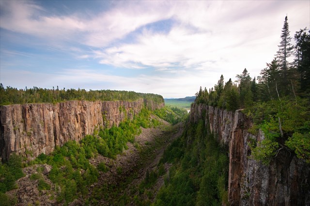
Ouimet Canyon Provincial Park features a one kilometre loop trail to two viewing platforms along the canyon’s rim. These platforms offer panoramic views of a 150 metre wide gorge and sheer cliffs that drop 100 metres straight down to the canyon floor! Located about 1 hour north of Thunder Bay, this park offers must-see views of one of natures marvelous creations!
Before We Begin:
- To get to this EarthCache: The parking coordinates for Ouimet Canyon Provincial Park are available seasonally from May to October.
- Hikers/snow-shoers are still welcome to walk on the roadway to access the hiking loop to the viewing platforms. It is a 3km (6km return) hike from the lower parking lot to upper parking lot which includes a climb of approximately 200 metres in elevation. This trek is only recommended for fit hikers.
- The terrain rating is based on the potential winter conditions and distance you will need to travel during the off-season. When you are able drive all the way to the top, it's more like a 1.5 terrain from the parking lot.
- Note: There is a nominal $2.00 per person fee to enter the park. As of the publication date of this EarthCache, it is collected via honor-system at a drop box and the fee goes directly to the maintenance of the park itself.
- Visitation to the park is day-use only. Be sure to visit the Ouimet Canyon Provincial Park website for the latest information about the park before you visit.
To get credit for this EarthCache, be sure to complete the logging tasks at the bottom of this page.
Ancient Origins of Ouimet Canyon
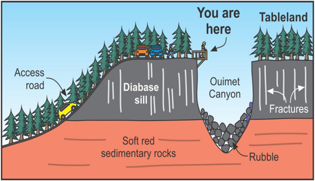
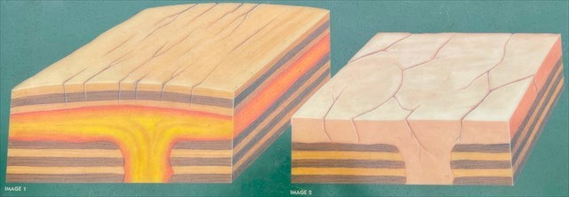
Ouimet Canyon's (pronounced we-met) history dates back over a billion years. Hot molten rock (magma) rose up from deep within the earth. About a kilometre beneath the earth's surface, the magma flowed horizontally to form a huge flat formation called a sill.
As the magma cooled, it became a hard rock called diabase. Over a period of several million years, the rocks above the diabase eroded away. Further cooling and exposure resulted in extensive cracking and fracturing in the diabase sill.
From here, the story of the canyon's formation can go either of two ways.
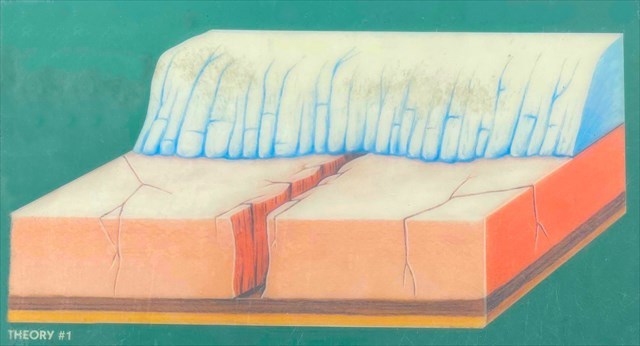
Theory #1
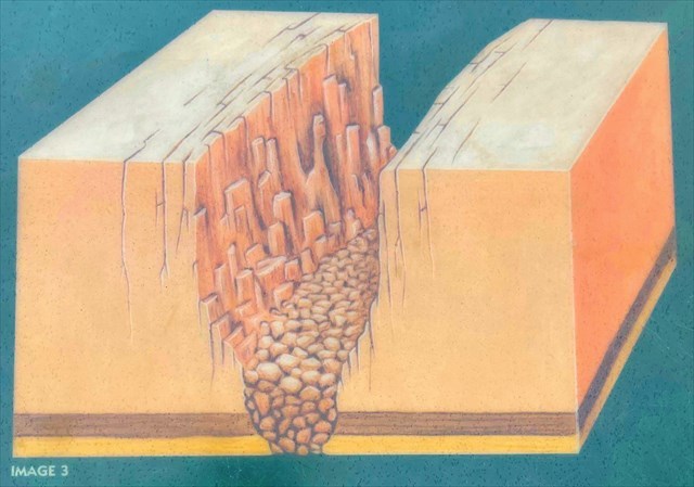
This theory suggests that the canyon formed during the height of the last glacial period, when the land was buried deep beneath massive mountains of ice. The tremendous weight of the ice may have caused the eastern part of the diabase sill to shift or slide 20 to 40 metres to the east. There was nothing east of the diabase to stop its sliding on the relatively smooth, slippery rocks beneath.
The shift resulted in the formation of a narrow canyon, with distinctly parallel, if not straight sides. Ice, wind and rain (the architects of time) chiseled and fractured the canyon walls, widened the canyon and created the talus slopes you see below.
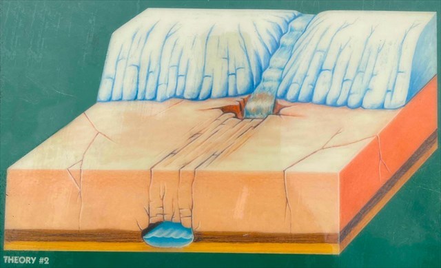
Theory #2
This theory suggests the canyon formed somewhat later, when the glaciers were slowly melting away. Meltwater from retreating glaciers flowed into a large crack in the diabase and tunneled through the softer rock below. Eventually the diabase above collapsed, instantly forming the canyon. Erosion then modified the shape of the canyon creating the landscape you see before you today.
Canyon Walls
Look across from the platform and notice the canyon walls. The diabase of the canyon's walls has a distinctive pattern of vertical jointing, resulting in a column-like appearance to the rock face. Over time, great blocks of rock have crashed to the canyon's floor, widening the canyon and covering the floor with shattered boulders measuring as much as ten metres across!
Some of the columns resist breaking away and a rock pinnacle may remain. For example, just to the left of this platform, the pinnacle guarding the west wall of the canyon is known as the Indian Head. Read the signboard for more information on the Legend of the Indian Head.
Fun Fact: Ouimet Canyon is so narrow that sunlight rarely reaches the canyon floor! Arctic-type vegetation that remains from the Ice Age (normally found 1000 km further north) continues to grow on the cold canyon floor.
To Get Credit For This EarthCache
Copy the questions below and send your answers via geocaching messages.
- DO NOT post the answers in your log.
- Group answers are fine, just let me know who all was there.
- Note: The photo task is a requirement for each account claiming a find. See acceptable EarthCache logging tasks effective June 10th, 2019.
- Please send the answers in a timely manner or it may result in the deletion of your log (no offense intended).
Logging Tasks
1| The name of this EarthCache: Ouimet Cany🌎n
2| The origin of Ouimet Canyon is puzzling because no river currently flows through it. Which of the two theories presented do you think was the origin of the canyon? Why do you think that?
3| In your log, please provide a photo of yourself with the canyon. Bonus points for having the Indian Head pinnacle behind you!
- If you prefer, the photo can be of a personal item here instead. Just make the photo unique to you and your visit. Feel free to have fun with this!
*IF YOU ENJOYED THIS EARTHCACHE,
CONSIDER GIVING A FAVORITE POINT!*
Sources:
Permission for this EarthCache placement was granted by the Park Superintendent for Ouimet Canyon Provincial Park.