This cache has been placed with special permission from the Town of Havre de Grace.
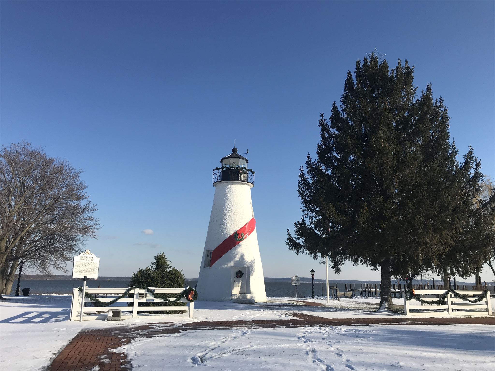
Concord Point Light has been a symbol of Havre de Grace for over 150 years. Today, it is no longer in use for its intended purpose. However, because of the way it was constructed, it provides a unique oportunity for a geology lesson. Like many buildings of the early to mid 1800s of the region, the Concord Point Light was built using Port Deposit Granite. This granite has only been found in Havre de Grace and in Port Deposit. No other place on earth has this exact granite. That said, it made it a perfect building material. Granite is strong and resiliant to weathering, a common issue for strucutres built near the Susquehanna River and Chesapeake Bay.
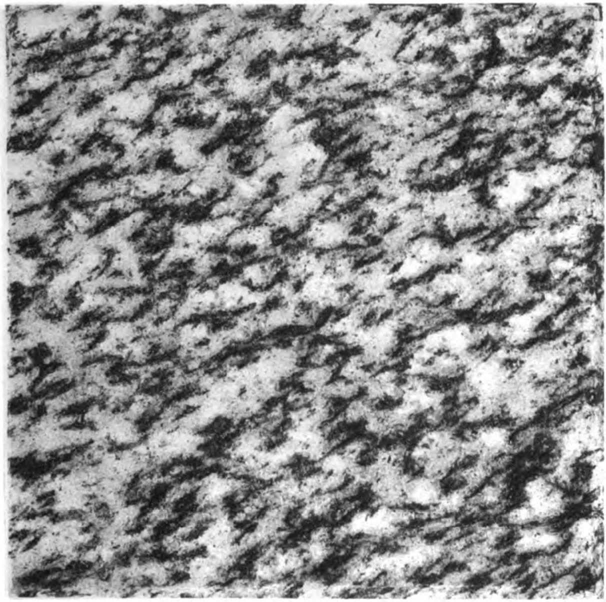
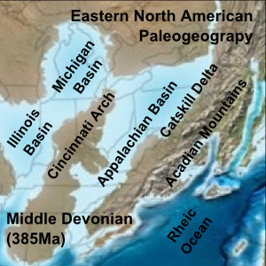
Let's discuss the geology of Port Deposit Granite. Port Deposit Granite (image above), or granite in general, is an igneous rock that cooled slowly over millions of years within the Earth. Over millions of years, it was uplifted and brought closer to the surface. It formed during the Paleozoic era, between 540 to 240 million years ago. It was during this time, specifically during the Devonian period roughly 385 million years ago that the Appalachian Mountains began to uplift and form as tall (or taller) than the modern Himalayas in Nepal. This occured as land masses offshore collided with the continent, causing the mountains to form and uplift. The convergence of land masses caused the underlying rock to squeeze and heat up. At some point in depth (likley hundreds of kms), there was melting that was occuring. When tectonic forces shifted, the Appalachian Mountains stopped uplifting. During the same time, the now melted rock layers began to slowly cool over the next few tens of millions of years.
Some of this newly cooled rock would become the Port Deposit Granite (among other local igneous rocks). As the Appalachian Mountains began erodding, so did the parts of the foothills which were full of softer materials that formed offshore (such as sedimentary rocks: sandstones, claystones, limestones, ect.) This allowed the harder igneous rocks to be closer to the surface (and at some points exposed on the surface). Igneous rocks are much more versatile and durable due to the lack of porous space inbetween grains, unlike sedimentary rocks. It is why they make great building materials, especially if an architect wants to insure the longevity of a building or structure. And besides, incorporating the local geology makes buildings aesthetically better.
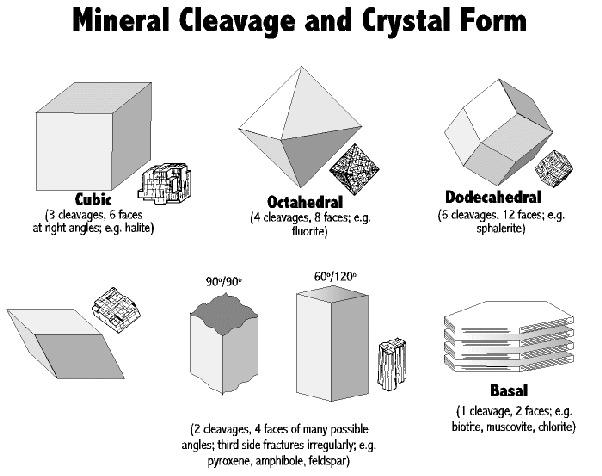
Port Deposit Granit differs from other granites due to its striations and deformities, most notabily with the biotite grains. Biotite is a common mineral in granite and appears as black specks with one single perfect cleavage plane. Along this cleavage plane, light is reflected which makes biotite shine in the sunlight if viewed from the right angle. Cleavage planes is the tendancy of a mineral to break along precitable axis(es). This is due to the crystal struture of the mineral. For example, graphite has one perfect cleavage plane (like biotite). It breaks similarly, but it is much, much weaker. Meaning it breaks more often compared to biotite. Graphite breaks in sheets along one axis, allowing it to slide off when dragged accross a surface such as a peice of paper. Graphite works well as pencil lead because it breaks so easily along this crystolagraphic axis. Bitiote is the same way, but on a much larger scale. Both bitotite and graphite have basal cleavage.
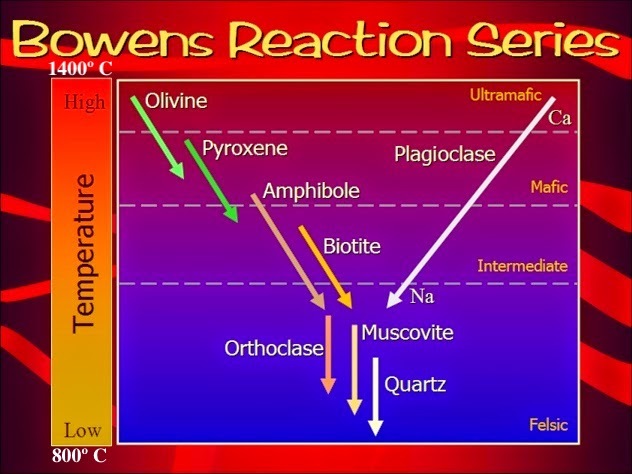
The reason why Port Deposit Granite is classifed as its own specific granite is because its biotite grains are elongated. This is due to the fact that when the granite formed, it was under extreme pressure, which made the cooling grains which were still partially a liquid, almost flow as the rock was squeezed. As the rock cooled, there became less and less space for the liquid to flow. Becuase different minerals have different melting and cooling tempuratures, this allows for minerals to be elongated as space for them to grow decreased. These elongations are called foiliations. If you refer to the top picture on this cache page, notice how the black biotite grains are elongated, mostly trending in a northeast-southwest direction. Bowens Reaction Series is a diagram that shows which common igneous minerals will begin to cool or melt at specific tempuratures. Note where biotite is compared to other minerals.
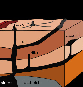
In addition to biotite (black), Port Deposit Grainte also contains quartz (white), hornblend, (black), and a trace ammount of other minerals. You can tell the difference between biotite and hornblend by the cleavage planes. Biotite has perfect cleavage on one axis, while hornblend has imprfect clevage on two axises. In some areas, Port Deposit Granite actually intruded into the exisiting bedrock. This can occur if enough pressure from the molten material (which will eventually cool to become Port Deposit Granite) fractures the exisit rock above, allowing a conduit for the molten material to flow into. These conduits are called dikes. If the dike reaches the surface, it will allow the molten material to cool and flow out in all directions (depending on topography at the time). In that case, we call these a sill.
Works Cited
https://en.wikipedia.org/wiki/Port_Deposit_Gneiss
http://www.mgs.md.gov/geology/building_stones_of_maryland.html
https://www.geologyin.com/2014/09/what-is-bowens-reaction-series.html
https://courses.lumenlearning.com/geophysical/chapter/igneous-rocks/
TO LOG A FIND ON THIS CACHE YOU MUST ANSWER ALL THE QUESTIONS BELOW. YOU CAN CONTACT ME THROUGH MY EMAIL OR THE GEOCACHING MESSAGE CENTER TO SEND YOUR ANSWERS. ANY INCORRECT ANSWERS MAY RESULT IN A CLARIFICATION RESPONSE FROM ME.
1. "Havre de Grace - Port Deposit Granite Walking Tour" on the first line of your email AND list all geocaching names of your party so I can match your answers to them. If you all want to learn something, I would prefer each cacher send me individual emails in the spirt of earthcaching.
At the above coordinates:
2. Find the Concord Point Light at the above coordinates. Describe the (a) textures of the granite that makes up the lighthouse. Also tell me the (b) thickness of the granite walls that make up the base of the lighthouse and (c) your reasoning as to why they are so thick (or thin).
Next, walk over to the John O'Neill Cannon directly behind the lighthouse (see waypoint section): N 39° 32.441 W 076° 05.082
3. Take a close up photo of the mineral grains of this rock using some sort of scale. Geologists often use coins, GPS', pens, shoes, notebooks, ect. You might want to be creative in what you use for your scale, however, the scale that you choose is entirely up to you. Make sure your photo is close enough to capture foliations that can be clearly seen. This MUST be uploaded to each found it log. As in if you are completing answers as a group, each log must have a unique photo attached to them. Do not send me any photos through the message center!
4. Describe the (a) textures, (b) colors, (c) relative abundance of quartz and biotite, and (d) average lengths and average trending directions of the biotite foliations. By trending, I am refering to the cardinal directions. To refer to the example in the description, you might say "northeast to southwest". If you are confused, look at the picture on the top of the cache page and notice the oirentation (trend) the foliations are in.
At one additional waypoint site of your choosing (see waypoint section for coodinates) excluding the John O'Neill Cannon:
5. Let me know which site you chose to visit by the name in the waypoint section. Describe the (a) textures, (b) colors, (c) relative abundance of quartz and biotite, and (d) average lengths and average trending directions of the biotite foliations. By trending, I am refering to the cardinal directions. To refer to the example in the description, you might say "northeast to southwest". If you are confused, look at the picture on the top of the cache page and notice the oirentation (trend) the foliations are in.
Questions to answer after you visited at least 1 additional site (not including the Lighthouse or John O'Neill Cannon):
6. Based on your answers, do you think that the Port Deposit granite that was used in the construction of these buildings/structures came from the same quarry? Do you think they came from a different quarry? Explain your reasoning. It may be helpful if you visit more than one additional site in the waypoint section, but again this is not required.