Skip to content

Porís de Candelaria EarthCache

A cache by XAX Message this owner
Hidden : 2/2/2022
Difficulty:
2 out of 5
Terrain:
2.5 out of 5

Size: Size:   other (other)

Join now to view geocache location details. It's free!

Watch

How Geocaching Works

Please note Use of geocaching.com services is subject to the terms and conditions in our disclaimer.

Geocache Description:


PORÍS DE CANDELARIA

ESP - ENG


Porís de Candelaria es un pequeño pueblo de pescadores situado dentro de una gigantesca cueva bajo un impresionante acantilado al lado del mar. Porís significa embarcadero o puerto natural y en él se encuentra la virgen de Candelaria. Pertanece al municipio de Tijarafe.

Tijarafe es un municipio canario situado al Noroeste de la isla de La Palma. La costa, acantilada y de difícil acceso, tiene una longitud aproximada de 11,5 km, que supone un 9,3% del perímetro total insular.

La orografía del territorio es muy abrupta y accidentada con una continuada pendiente desde la cumbre hasta el mar, cortada por multitud de barrancos. La pendiente se suaviza entre los 400 y 800 metros, altitud en la que se sitúa la mayoría de la población de las distintas entidades. La parte costera está cortada en el tramo final de los barrancos y terminan en un acantilado casi lineal de unos 200 metros de altura.


Origen

Geológicamente hablando, estamos ante una de las zonas más antiguas de la isla de La Palma. Las lavas proceden de la Caldera de Taburiente que se formó hace 2 millones de años. Como todas las calderas y en los volcanes en escudo, su origen está en la existencia de un cráter relativamente extenso con lava que al enfriarse produce rocas basálticas. Las erupciones de las calderas son relativamente tranquilas del tipo hawaiano y la lava suele formar coladas sucesivas que van agrandando el volcán más en superficie que en altura.

¿Qué es el basalto?

La variedad más común de roca producida por magma es el basalto. El basalto es una roca ígnea volcánica que se caracteriza por tener un color oscuro, producto de su alto contenido en hierro y magnesio. Se constituye principalmente de óxidos metálicos como el óxido de hierro, óxido de silicio y de magnesio, entre otros. Pueden presentarse pequeños fenocristales en su composición, aunque también se presenta en forma de cristal sin o con muy pocos cristales de forma visible. Presenta una alta dureza (8 en la escala de Mohs) y manejo fácil, en cuanto a su explotación. Por sus características físico-mecánicas, es un material idóneo para la construcción, para revestimientos y pavimentos exteriores, incluso los de circulación intensa (adoquines, piezas estándar, etc.). También es usado como elemento decorativo por su estética y al poder ser tratado en forma, corte, molde y color. De forma inusual, también es utilizado en tratamientos de spa como son los masajes.

El basalto en forma natural se encuentra característicamente como grandes columnas y, según su ubicación y formación, se pueden derivar algunas formas peculiares del basalto, como por ejemplo arcos basálticos o prismas basálticos.


Plataforma de abrasión

En la zona baja de los acantilados existe la llamada plataforma de abrasión, restos muy desgastados del continente en donde encontramos grandes rocas derrumbadas del acantilado sobre las que se prosigue la acción de la erosión marina hasta convertirlas en arenas (que transportadas por la corriente, terminarán formando playas, dunas litorales, flechas…)


Indicaciones

Para llegar desde el aparcamiento recomendado hasta las coordenadas del earthcache, tenéis unos 15 minutos a pie. Cuidado ya que la carretera para llegar al aparcamiento es muy estrecha, con pendiente y con curvas. Si el aparcamiento está lleno, tenéis un par de zonas de aparcamiento más arriba.

En la zona hay poca cobertura de móvil, tenedlo en cuenta! Si tenéis prisa mejor dejadlo para otra ocasión ya que es un sitio para ir con calma y poder disfrutar del lugar.


Para registrar este earthcache, debéis ir a las coordenadas y enviar un correo electrónico (podéis hacerlo desde nuestro perfil) con las respuestas a las siguientes preguntas. Sólo contactaremos si hay algún problema con alguna de las respuestas.
 

1.- De dónde proceden las lavas que estamos pisando?
A. Volcán de Cumbre Vieja

B. Caldera de Taburiente
C. Volcán de Teneguía
D. Volcán del Croscat

2.- ¿Cuál es la dureza del basalto en la escala de Mohs?

3.- Observa la parte baja del acantilado. ¿Puedes observar derrumbes que se acumulan sobre la plataforma de abrasión? En caso afirmativo, ¿A qué crees que són debidos?

4.- Observa las paredes que hay en el acantilado por encima de la cueva. Se pueden observar distintas capas ¿Por qué?

5.- Hazte una FOTO con tu GPS y/o con tu nick en el embarcadero de Porís de Candelaría con el oceano al fondo. Desde este punto podrás ver lo que parece la silueta de la isla de La Palma tal como se puede ver en la primera imagen del listing. Recuerda que esta fotografía es obligatoria para demostrar que has visitado este earthcache.


Si no recibimos las respuestas, el log será borrado sin previo aviso.

También podrán ser borrados todos los logs que no incluyan la fotografía de la pregunta 7 (desde la actualización de las guidelines de 2019 la fotografía puede ser obligatoria para demostrar que se ha visitado el sitio).


ENGLISH VERSION

PORÍS DE CANDELARIA [ENG]

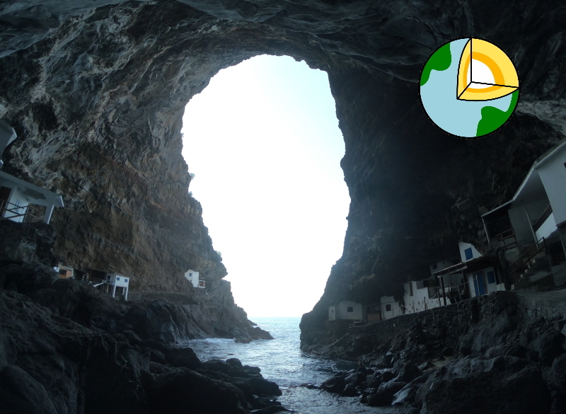
Porís de Candelaria is a small fishing village located inside a gigantic cave under an impressive cliff by the sea. Poris means pier or natural harbor and in it is the Virgin of Candelaria. It belongs to the municipality of Tijarafe.

Tijarafe is a Canarian municipality located northwest of the island of La Palma. The coast, steep and difficult to access, has an approximate length of 11.5 km, which is 9.3% of the total perimeter of the island.

The orography of the territory is very steep and rugged with a continuous slope from the summit to the sea, cut by a multitude of ravines. The slope is smoothed between 400 and 800 meters, an altitude at which most of the population of the various entities is located. The coastal part is cut in the final section of the ravines and ends in an almost linear cliff about 200 meters high.


Origin

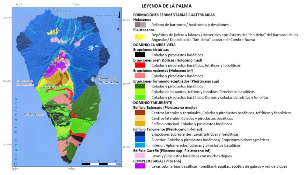
Geologically speaking, we are facing one of the oldest areas of the island of La Palma. Lava comes from Caldera de Taburiente which was formed 2 million years ago. Like all calderas and shield volcanoes, its origin is in the existence of a relatively large crater with lava that when cooled produces basaltic rocks. Caldera eruptions are relatively calm, in the Hawaiian type, and lava often forms successive flows that enlarge the volcano more in surface area than in height.

What is basalt?

The most common variety of rock produced by magma is basalt. Basalt is a volcanic igneous rock that is characterized by a dark color, a product of its high content of iron and magnesium. It consists mainly of metal oxides such as iron oxide, silicon oxide and magnesium oxide, among others. Small phenocrysts may be present in its composition, although it is also present in the form of a crystal without or with very few crystals visibly. It has a high hardness (8 on the Mohs scale) and easy handling, in terms of its operation. Due to its physical-mechanical characteristics, it is an ideal material for construction, for coatings and exterior pavements, even those with heavy traffic (cobblestones, standard parts, etc.). It is also used as a decorative element for its aesthetics and can be treated in shape, cut, mold and color. Unusually it is also used in spa treatments such as massages.

Basalt is naturally found as large columns and, depending on its location and formation, some peculiar shapes of the basalt can be derived, such as basaltic arches or basaltic prisms.
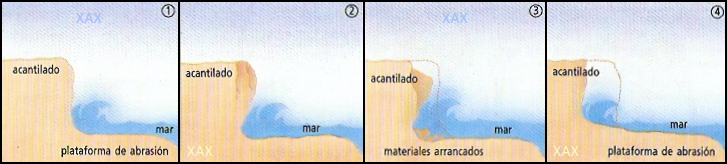
 

Abrasion platform

In the lower part of the cliffs there is the so-called abrasion platform, very worn remains of the continent where we find large rocks collapsed from the cliff on which the continuous action of marine erosion turns them into sands (which transported by the current, will end forming beaches, coastal dunes…).


Indications

To go from the recommended parking to the coordinates of the earthcache, you have a walk of about 15 minutes. Be careful as the road to the car park is very narrow, sloping and winding. If the parking is full, you have a couple of parking areas above.

There is low mobile coverage in the area, keep that in mind! If you are in a hurry, better leave it for another moment because it is a place to go calmly and be able to enjoy the place.


To register this earthcache, you will need to go to the coordinates and send us an email (you can send it from our profile) with the answers to the following questions. We will only contact you if there is a problem with any answer.
 

1.- Where do the lavas we are stepping on come from?
A. Cumbre Vieja Volcano
B. Caldera de Taburiente
C. Teneguía Volcano
D. Croscat Volcano

2.- Which is the hardness of basalt on the Mohs scale?

3.- Observe the lower part of the cliff. Can you see collapsed rocks accumulating on the abrasion platform? If so, what do you think they are due to?

4.- Observe the walls on the cliff above the cave. Different layers can be observed. Why?

5.- Take a PHOTO with your GPS and/or your nickname at the Porís de Candelaria pier with the ocean in the background. From this point you can see the silhouette of La Palma island as you can see in the first image of the listingRemember that this photography is obligatory to show that you have visited this earthcache.


If we do not receive the answers, the log will be deleted without notice.


All logs that do not include the photo of the question 6 may be deleted (from the update of the 2019 guidelines, photography may be obligatory to demonstrate that the site has been visited).

Additional Hints (No hints available.)