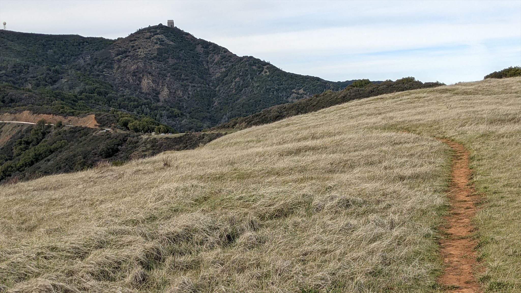
Welcome to the The Hummingbird! Mt Umunhum (Ohlone word for "Resting Place of the Hummingbird"), stands high and noticeable above Silicon Valley. Its signature look is from The Cube, a radar watchtower created in the 1960s during the height of the Cold War. I'm guessing local outdoorspeople of the time weren't clamoring for access to all the highest peaks in the Bay Area the way they are today. Fortunately this persistent class eventually effected a change, resulting in the trail to the top being opened in the fall of 2017, after significant effort and cleanup by many dedicated organizations and individuals.
This cache beckons you towards the peak, requiring you to take (at least) the halfway trail from the posted coordinates at Bald Mountain parking lot to the top and back. This starts you at 2317 feet, with "only" 1170 feet of elevation climb to get to the peak at 3489 feet. The trail is beautifully maintained and a gentle climb. Mt Umunhum is one of the Northern California Six Pack of Peaks, and one of the reasons I visited it to place this cache. It is also #7 on the Nifty Ninety peaks of the Bay Area.
This cache is also part of a new series of caches I'm creating called the Mikey Matrix Seed caches (see below), and hopefully helps with Multi Cache dates and DT ratings.
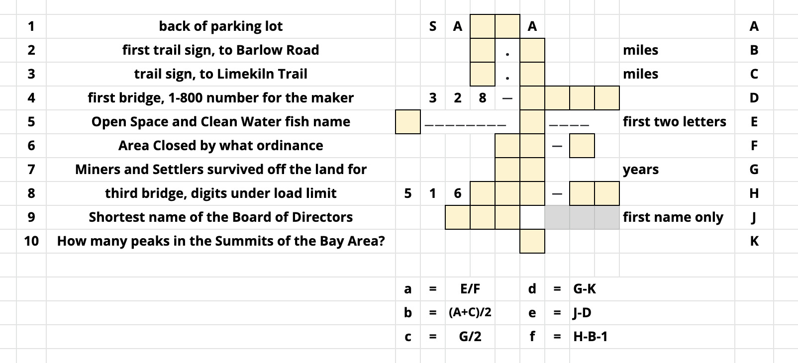
For this 3.5/3.0 multi you'll have to earn both the difficulty ("quite difficult") and terrain rating ("more than 2 miles on varied terrain"). You'll need to keep notes on many signs and markers along the way. Some waypoints are given, some you will have to find. In particular keep an eye out for the three bridges between the posted coordinates and the peak. The data gathering is summarized in the table that follows, but first described in the paragraphs below.
Your first waypoint (#1) is at the back of the parking lot. You're looking for the name of this gate entrance into Sierra Azul park. The 5 characters are SA__A. Add the two digits together to get A.
Your second waypoint (#2) is the first trail sign you see as you cross the road, indicating distances to Barlow Road, Guadalupe Creek Overlook, and the summit. The distance to Barlow Road is _._ miles. Add the two digits together to get B.
Waypoint #3 is given as N37 09.444 W121 52.883. It has a trail sign. The distance to Limekiln Trail is _._ miles, though we're not headed that way. Add the two digits together to get C.
Waypoint #4 is the first bridge you'll cross. On both sides of the bridge is an etched placard from the bridge maker. The phone number for the maker is 1-800-328-____. Add the final four digits together to get D.
Waypoint #5 is the lovely Guadalupe Creek Overlook, at N37 09.536 W121 53.459. There's an information sign touting Open Space and Clean Water. On the sign is the photo of one fish, with a two word name. Take the two letters that start those two words and convert to their letter value (A=1..Z=26). Add them together to get E.
Waypoint #6 is an Area Closed sign at N37 09.471 W121 53.369. By what ordinance is it closed? __-_. Add the three digits together to get F.
Between the second and third bridge is waypoint 7, with an information sign about Miners and Settlers. Refugees from the Franco-Prussian War survived off the land in "Austrian Gulch" for __ years. Add the two digits together to get G.
Waypoint #8 is the third bridge you'll cross. On both sides of the bridge is a an etched placard like before. Under the Load Limit is etched the digits 516___-__. Add the final five digits together to get H.
Waypoint #9: you've reached the top! At the coordinates N37 09.625 W121 53.963 is a placard indicating the dedicated Board of Directors of the Midpeninsula Regional Open Space District (round of applause) that brought you this trail and mountain top opening in 2017. Find the shortest name of the board of directors member, three letters each first and last name. Convert the letters of the first name only to numbers. Add them together to get J.
Your final Waypoint, #10. Under the cover at N37 09.636 W121 53.877 are several information signs. The one titled Summits of the Bay Area highlights how many peaks (one of which is Umunhum)? The number of peaks is K.
You can now find the container at N37 09.abc W121 53.def, where a = E/F, b=(A+C)/2, c=G/2, d=G-K, e=J-D, f=H-B-1.
Woohoo, enjoy the trek up and down this historic and panoramic prominent Summit of the Bay Area!
Certitude is not required, but can help confirm your math, and give a more accurate hint. You can also check against the final coordinates checksum of 55.

You can validate your puzzle solution with certitude.
Enjoy the trek to and from the Six Pack Umunhum peak, and enjoy the views all along the way!
Congratulations to Geokashers for the FTF!
About the Mikey Matrix Seed [MMS] series: this series will be sprinkling caches around the area to fill in holes in the D/T or calendar matrix to hopefully help with challenges that abound.
For this cache, it is placed on a date (January 16) that has no other multi-caches within 66 miles, and has a D/T rating of 3.5/3.0, where the next closest Multi Cache of that rating is over 36 miles away.