*** For an English version, see below ***
Ich weiß, ich weiß. Das Listing ist zu lang. Der Cache ist krass aufwändig. Der Weg ist zu weit. WIGs stürzen ständig ab. Aber keiner hat behauptet, dass das hier einfach werden würde (siehe Attribute). Das würde dieser Straße auch nicht gerecht. Also: Entweder ihr zieht das durch, oder aber ihr bedient den „Ignore“ Button. Vielen Dank einmal mehr an Platschkuh für die Hilfe beim Betatesting, insbesondere in der Identifizierung der Stationen. Die Zonen vor Ort wurden ebenfalls alle getestet und lösen aus, hope it will work. Bei einigen der Zonen muss man ein bisschen hin und her laufen bis sie auslösen, beim Testen war dies allerdings nie mehr als maximal 10 min nötig.
Doch nun genug der Vorrede......
Die WIG-Cartridge findet ihr hier:
https://www.wherigo.com/cartridge/details.aspx?CGUID=8d843bbd-4af9-421e-9833-c494b52720a6
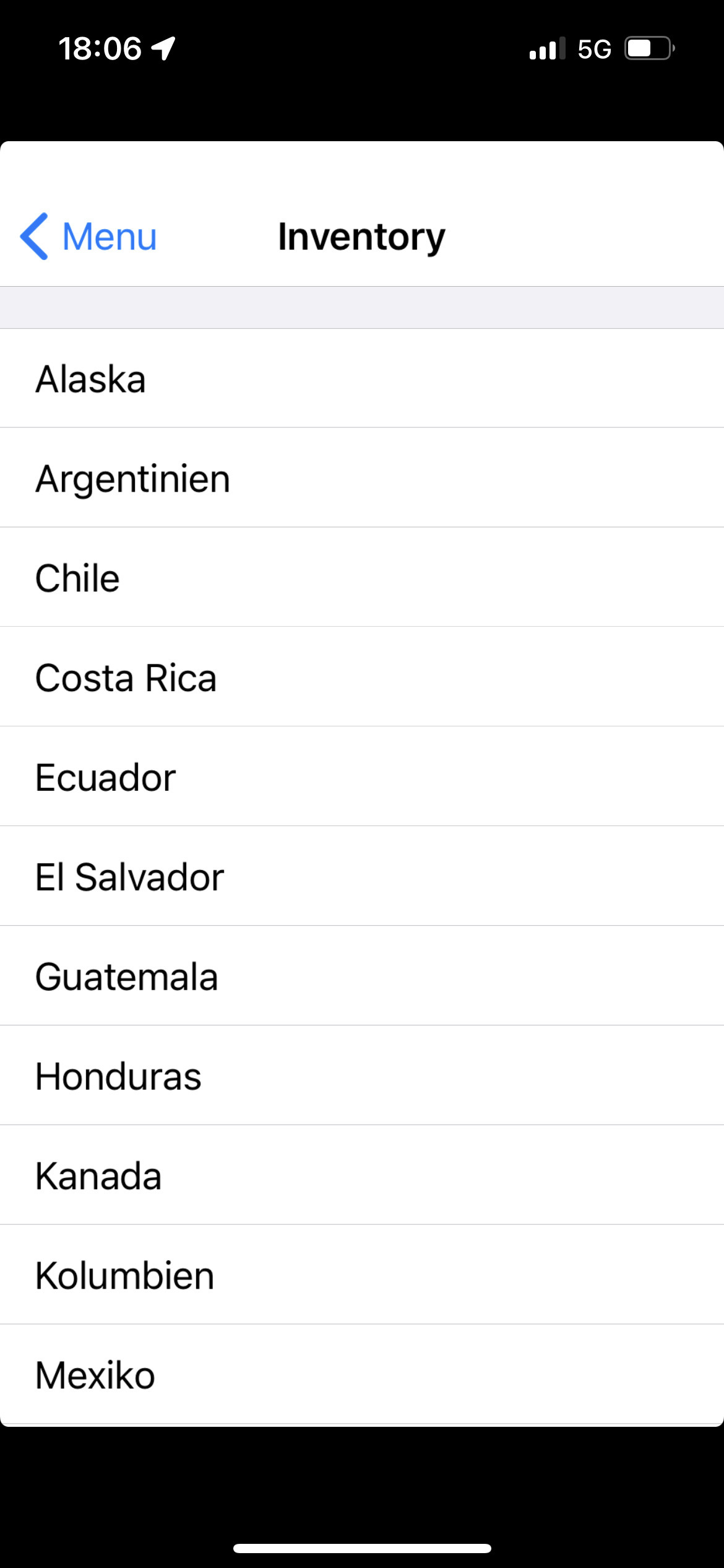
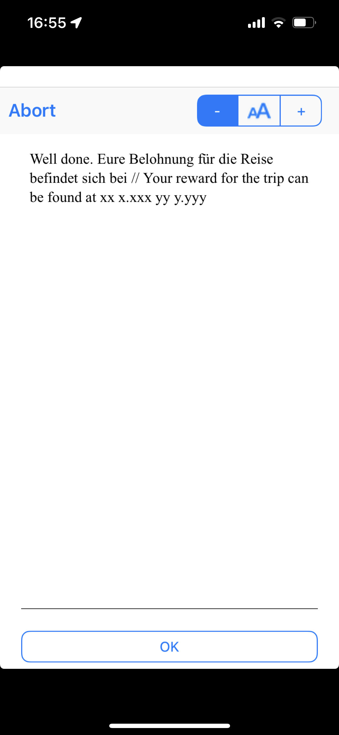
Beachtet die WIG Basisnutzregeln, die hier nicht alle nochmal aufgeführt werden können. Zwei Anmerkungen dennoch kurz, da ich sie selbst immer falsch mache: Ihr müsst die Cartridge schon an haben, wenn ihr die Zonen betretet. Beim Anstellen der Cartride innerhalb einer Zone löst diese nicht aus, dann müsst ihr nochmal raus und wieder rein gehen. Die Finalkoordinaten erhaltet ihr wenn ihr alle Zonen besucht und alle Länder "eingesammelt" habt (könnt ihr im Inventory sehen) nach dem VERLASSEN der letzten Zone (sowohl ins Inventory als auch als kurze Textnachricht). Beachtet, dass ihr entweder im ersten oder letzen Land der Panamericana enden müsst (s.u.), dazwischen könnt ihr die Reihenfolge frei wählen. Ich würde im letzten (südlichsten) Land enden, die Qualität der Erfrischung hier ist exzellent!
So sieht das Ganze im Inventar aus wenn ihr durch seid (Handy Screenshots) und so sieht die Message aus, mit den Finalkoordinaten.

Getestet wurde mit einer für "Pocket PCs" kompilierten Cartridge auf einem IPhone. Die anderen Versionen wurden bis jetzt nicht getestet. Rückmeldungen dazu gerne!
Achtung: Ich würde mich sehr freuen, wenn ihr nicht versucht die Finallocation ganz ohne zu spielen aus dem WIG-Programm mit Computer-Hilfsmittel rauszuziehen. Das ist, finde ich zumindest, unfair den Spielern gegenüber die den WIG tatsächlich bezwingen (entweder virtuell am Computer oder sogar real). Würde mich zudem freuen wenn der eine oder andere (so wie wir beim testen) den WIG zudem auch in der Realität spielt, bei einer virtuellen Computerunde müsste die Bewertung zur Dose natürlich etwas niedriger sein. Wenn ihr den WIG gar nicht spielen wollt (nicht virtuell und nicht real), nutzt doch einbach den "Ignore" Button. Danke! Es wird zudem einen Bonus der Kontinente-Serie geben, in den eine Frage eingebaut wird, die nur durch echtes Spielen des WIG zu beantworten sein wird.Wenn der eine oder andere Lust hat ein Photo von der "Reise" mit hochzuladen, wäre das toll!
-------------------------------------------------------------
Amerika. Ein großer Kontinent, von dem sich kleine Splitter überall auf der Welt finden, so auch bei uns in München und Umgebung.
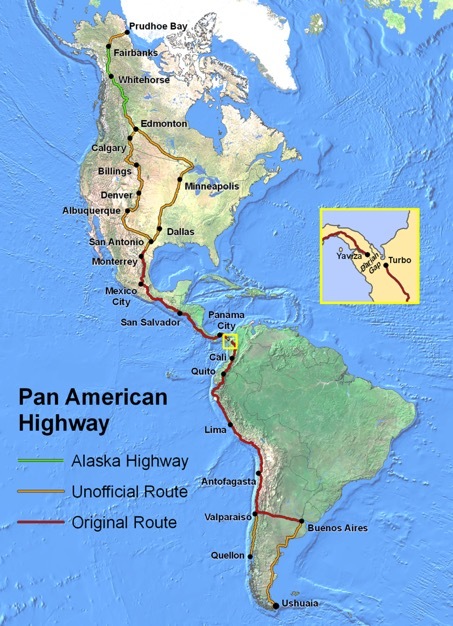
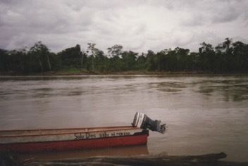
Und Amerika beherbergt eine der berühmtesten Straßen der Welt. Die Panamericana. Ca. 30.000 Kilometer lang. Mit allen „inoffiziellen“ Erweiterungen reicht sie von Alaska bis nach Feuerland. Am stilvollsten befährt man sie natürlich mit dem Motorrad (jedweder Art, für ein besonders exotisches Beispiel siehe unten).
© Wikipedia
Ganz so viel Aufwand muss für diesen WIG nicht betrieben werden, aber auch hier ist man gut und gerne einen Tag unterwegs, wenn man es denn an einem Tag machen möchte. Diese spezielle Münchener Panamericana führt euch zu Orten mit Bezug zu den Ländern die ihr auf eurer Reise durch den Kontinent besucht. Ihr müsst diese Orte aber nicht der Panamericana-Reihe nach abfahren, sondern dürft die Reihenfolge des Besuchs (fast) frei wählen. Das erlaubt es euch, den WIG auch in diversen Sitzungen zu absolvieren.
Achtung: Ihr müsst allerdings, da ihr ja entweder von Süd nach Nord oder (wie im Text) von Nord nach Süd reist, im nördlichsten oder im südlichsten Land enden.
Und um das Ganze noch zu verkomplizieren, müsst ihr die zu besuchenden Orte auch noch herausfinden. Zu jeder Koordinate gibt es einen Geochecker, der auch gewisse Ungenauigkeiten akzeptiert. Dennoch sind die Locations teilweise so groß, dass eine gewisse Unschärfe bleibt. Orientiert euch, wenn ihr den Checker nutzen wollt an den angegebenen Locations auf Google Maps. Im WIG sind die Zonen entsprechend größer so dass dies vor Ort kein Problem darstellen dürfte.
Zur inhaltlichen Einstimmung empfehle ich einen sehr unterhaltsamen ganz besonderen Zweirad-Reisebericht zur Panamericana in multiplen Episoden. Den findet ihr hier
https://c90adventures.co.uk/category/alaska-to-argentina/.
Der Reisebericht hat auch Bezug zu unserem Cache. Das Teil so runterzurocken, ist wirklich nur was für Die Hard Jungs und Mädels. (nur als Disclaimer: Ich hab persönlich nix zu tun mit Ed March et al.).
Doch nun zu unserem Trip:
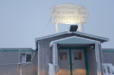
Schon wo die Panamericana tatsächlich beginnt, ist nicht ganz einfach zu beantworten und umstritten. Wir entscheiden und jetzt mal für Prudhoe Bay. Z.B. hier.
 © Google Maps. Prudhoe Bay.
Die Münchener Location für das erste „Land“ (bzw. eigentlich ist es genau genommen nur ein "State" ist einfach. Hier (A) gilt das Wiener Übereinkommen auch für die amerikanischen Freunde aus dem hohen kalten Norden.
Geochecker Location A: GeoChecker.com.
Doch weiter geht’s, immer nach Süden. Nach der ersten Grenze nehmen wir die westliche Variante der hier noch „unoffiziellen“ Panamericana und kommen in die Stadt des Eishockeys und der olympischen Winterspiele mitten in der Prärie. Von hier ist es nicht weit nach Banff und bis zum legendären Lake Louise (und seinem Skigebiet), ein unbedingt emfehlenswerter Trip. Zu sehen sind die Rockys schon vom schicksten Aussichtspunkt der Stadt.
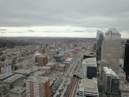 © selbst. Calgary.
Auf dem Weg dorthin machten wir seinerzeit eine interessante Bekanntschaft, die fotografisch festgehalten wurde.
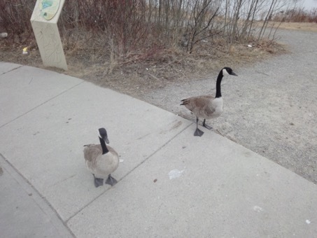 © selbst. Calgary.
Die findet ihr - allerdings bitte im übertragenen „namentlichen“ Sinne - auch als "Kleidungsbestandteil" in München J (B, bitte nicht im Zoo o.ä. suchen, siehe Hint).
Geochecker Location B: GeoChecker.com.
Nach dem Stopp geht es weiter, immer dem Äquator entgegen. Im nächsten Land gibt es viel zu sehen und unzählige alternative Routen. Um unseren nächsten Ort zu finden wechseln wir auf die rechte Routenvariante und machen hier Halt. Classic American.

Auch die gibt es so ähnlich in München (C). Bei der Münchener Variante bitte den „Pitch“ besuchen.
Geochecker Location C: GeoChecker.com.
Weiter geht’s, natürlich gen Süden, nach San Antonio. Solltet ihr hier stopovern, ist ein morgendlicher Lauf entlang des River Walk empfehlenswert.
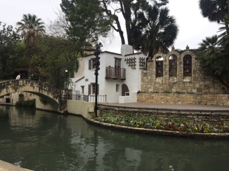 © selbst. San Antonio.
Sieht fast schon nach dem Nachbarland im Süden aus. Und auch zur Grenze ist es von hier nicht mehr weit. Und in ein neues Land, nein eine neue Welt. Wir sind in Lateinamerika.
 © selbst. Mexican Border.
Besonders schön sind hier die bunten und pulsierenden Mercadores (D). Comida y cultura lado al lado.
Geochecker Location D: GeoChecker.com.
Weiter nach Süden reisen wir, durch la Capital, den Moloch, und entlang der berühmten Halbinsel in das erste Land das nun wirklich den Beginn von Mittelamerika markiert.
Nach Passieren der Grenze gönnen wir uns mal eine Pause bei einem Cafesito aus lokaler Bohne. Kann man ja auch in München machen, in einem schönen Kombinationsnamenkauderwelsch (E), aber vor Ort ist‘s natürlich noch stilechter.
Geochecker Location E: GeoChecker.com.
Auch das nächste Land, ist classic Mittelamerika. Auf unserer Fahrt kommen wir in der Hauptstadt an einer der Kirchen der Iglesia Luterana Salvadoreña Gemeinde vorbei. Oh, esperas un minuto, von dieser Gemeinde haben wir doch auch in München schon gehört, und zwar hier (F).
Geochecker Location F: GeoChecker.com.
Und weiter geht es in den Süden. Noch einer dieser mittelamerikanischen Kleinstaaten. Auch hier gilt es, einen Abstecher zu dessen offiziellen Abgesandten in der bayrischen Hauptstadt zu erledigen (G). Achtung bei den Abgesandten in München die Lage kürzlich etwas unübersichtlicher geworden. Siehe Hint für den hier gemeinten und den richtigen "Ort".
Geochecker Location G: GeoChecker.com.
Nach so viel offiziellem Tamtam kommen wir nun in ein weiteres kleines Land, auch von hier gibt’s natürlich einzigartiges und (allerdings je nach gusto) durchaus sehr schmackhaftes zu entdecken. Z.B. die Maduro Torro und ihre Schwestern. Und auch die haben es natürlich schon bis nach München geschafft (H), in München z.B. in der Nähe von "Ecuador"
Geochecker Location H: GeoChecker.com.
Und schon wieder eine Landesgrenze, das geht hier flugs. Und wieder ein Land in dem die Natur Produkte hervorbringt, die wir sehr schätzen. Nicht für Kinder ist der....(jaja ich weiß, nicht mehr ganz politically correct der Spruch), und der kommt dann nicht selten von hier. Und wird in München veredelt von einer Firma mit recht scharfem Namen (I). Die hat sogar ein Geschäft, in dem man ein bisschen Mittelamerika mit nach Hause mitnehmen kann.
Geochecker Location I: GeoChecker.com.
Wo bitte geht’s ins nächste Land? Das hat sich fast jedes Kind in Deutschland wohl schon einmal gefragt. Der Grund dafür ist ein Mann, der doch tatsächlich auch einmal in der Nähe vom München an einem See gewohnt hat. Doch bloß wo genau (J)? Hieß das nicht irgendwie Vogelhügel? Oder ähnlich? Ist gar nicht soo leicht herauszufinden und ist der weiteste "Reiseabstecher" der gesamten Münchener Panamericana.
Nachdem wir nun eine der berühmtesten Wasserstraßen der Welt überquert haben, wird es auf der echten Strecke kompliziert mit der Weiterfahrt. In Yaviza, am sogenannten „Darién Gap“ ist Schluss an Land. Die direkte Weiterfahrt nach Südamerika ist nach wie vor nicht möglich. Wie man die „Lücke“ reisetechnisch kreativ und kostengünstig überwindet (zumindest mit einem Honda-Mofa) ist über den Link am Anfang zu bestaunen. Nachdem also auch wir die "Lücke umschifft haben" (nur wirtuell, in München geht das problemfrei), setzen wir unseren Fuß erstmals nach Südamerika. Tolles superabwechslungsreiches Land (abgesehen von einigen kleineren Drogen- und Guerillaproblemen). Und eine recht eigene, ziemlich gute Küche. Die kann man auch in München genießen, z. B. in „meinem Haus“ (K).
Geochecker Location K:GeoChecker.com.
Doch nun weiter, wieder eine Grenze und dann das kleine Land am Äquator, das von hohen Andengipfeln bis zum Amazonasregenwald so einiges zu bieten hat.
 © selbst. Amazonasbecken, Ecuador. Irgendwie das Motto von Südamerika...
Besonders die Berge locken auch viele Oberländer Alpinisten ins Land die auf dem Spuren Edward Whympers, die spektakulären Andengipfel erklimmen möchten, erste Anlaufstelle in der Hauptstadt ist die „Asociacion de Excursionismo y Andinismo de Pichincha“. Aber Moment, wen treffen wir denn da aus München auf Austauschfahrt. Die haben doch normalerweise hier (L) ihr Hauptquartier.
Geochecker Location L:GeoChecker.com.
Nach so viel Outdoor-Abenteuer, geht es nun weiter gen Süden in das Land der Inkas mit der berühmten (und ziemlich überlaufenen) Hochstadt in den Anden und dem ebenso berühmten See mit den Inseln aus Stroh. Hier lebt auch an vielen Orten noch die Indiokultur bis heute. Und auch diese ist in München vertreten, man muss nur nach dem Boten auf Quechua suchen (M).
Deine Lösung für die Koordinaten M dieses Rätsels kannst du auf geochecker.com überprüfen. GeoChecker.com.
Kulturell gestärkt geht es nun in ein weiteres südamerikanisches Land mit Küsten, berühmten Wüsten und spektakulären Andengipfeln. Aufgrund seiner Länge überspannt er eine gigantische Anzahl von Klima- und Vegetationszonen. Es gibt auch eine große Expat-Community aus diesem Land in Deutschland und speziell auch in Bayern. Und deshalb haben sie eine offizielle Vertretung in München (N).
Geochecker Location N: GeoChecker.com.
Wir verlassen die Pazifikküste und reisen quer durch den Kontinent in die „Stadt der guten Luft“ und damit in ein neues (und unser letztes) Land. Auch wenn die „offizielle“ Panamericana hier endet, fahren wir natürlich die Variante noch weiter, nun wieder straight gen Süden. Nach einigen hundert Kilometern bietet sich nochmals ein spektakulärer Abstecher ins chilenische Grenzgebiet zu einer der berühmtesten Berggruppen unseres Planeten an. Hier wurde vielfach Bergsteigergeschichte geschrieben, ein jeder der sich für die Geschichte des Bergsteigens interessiert, kennt das Drama um Cesare Maestri und Toni Egger. Der Berg mit dem Schneepilz wurde vor einigen Jahren nun auch vom leider bereits verstorbenen David Lama zusammen mit Peter Ortner - filmisch begleitet - über die Kompressorroute frei bezwungen. Aber nicht nur auf Bergen gibt’s Eis aus Patagonien sondern auch zum kulinarischen Genuss. Und den kann man sogar in München goutieren (O).
Geochecker Location O:GeoChecker.com.
Auf dem letzten Teilstück geht es nun ganz tief in Richtung Süden bis nach Ushuaia im südlichsten Feuerland. Zufrieden mit unserer Reise um die halbe Kugel von der Arktis bis nahe an die Antarktis, nehmen wir uns nochmal ein Zimmer, bevor das große Abenteuer endet und es von hier wieder mit dem Flugzeug gen Heimat geht.
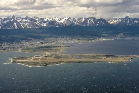 © Wikipedia. Ushuaia.
Wenn ihr die Locations alle habt, schwingt euch auf euer Iron Horse (es muss ja keine C90 sein) oder in euer Cachemobil der Wahl und macht euch auf die Reise. Bei den Proberunden hab ich die Reise (bis auf die Seenahe Station ausserhalb) nur mit öffentlichen Verkehrsmitteln gemacht, auch gut möglich.
Zum Final: Die Dose selbst liegt an einer Strasse mit Ausblicken auf die Alpen, die den Anblicken der Anden von der Panamericana nicht nachstehen.Die Dose selbst bitte, nachdem ihr die Koordinaten bekommen habt, vorsichtig heben/und insbesondere auch forsichtig auspacken sowie gut wieder einpacken und verstecken, damit sie ein Weilchen hält. An der Finallokation bitte etwas forsichtig agieren, hier fahren Autos, natürlich muss man auf dem Weg zur Dose nirgens Autobahnbereiche betreten, aber auch auf den Landstraßen hier ist manchmal viel Verkehr. Also vorsicht. Ich würde auch dringend raten nicht direkt mit dem Auto vorzufahren, da es hier keine Parkplätze gibt, sondern von der angegebenen Parklocation aus zu laufen, ist nur ein kleiner Spaziergang. Wer die anderen Caches der Serie von mir kennt, wird bemerken das die Finalcoords eines anderen Kontinentes hier ebenfalls in der Nähe liegen, insofern könnt ihr hier ggf. auch 2 Fliegen (bzw. Kontinente) mit einer Klappe schlagen.
Und damit nun genug des Textes: Good luck und viel Spaß!!
Und auch Amerika gibt es im Banner, falls gewünscht, guess the city 
<img src="https://img.geocaching.com:443/d389610e-0253-40b4-b17a-4704172e054d.png">
************************************************************
English
Please note: The English text comes without pictures and without the Geocechecker links for the specific locations you have to visit. Please use the Geochecker Links in the German Listing above. For Hints to finding the places please use the German text and translate through Google Translator, there was not enough room for an englich translation, sorry.
The cartridge for the WIG can be downloaded here:
https://www.wherigo.com/cartridge/details.aspx?CGUID=8d843bbd-4af9-421e-9833-c494b52720a6
Observe the WIG basic rules of use, which cannot all be repeated here. Two short comments, since I always make these things wrong myself: You have to have the cartridge on when you enter the zones. When turning on the cartride within a zone, it does not trigger, then you have to go out and back in again. You will receive the final coordinates when you have visited all zones and "collected" all countries (you can see this in the inventory) after LEAVING the last zone (both in the inventory and as a short text message). Note that you either have to end in the first or last country of the Panamericana (see below), you can freely choose the order in between. I would recemend to end up in the last (southernmost) land, the quality of refreshment here is excellent!
For pictures on what it should look like on your phone when you are through see German listing. The game has been tested with the pocet computer version of the cartridge on an iphone. The other compilations have not been tested by me.
Attention: Please do not pull out the final location from the WIG with computer tools without playing the WIG at all. At least "travel" the locations virtually on the computer. In addition, I would love it, if one or the other will truely play this one in "reality" (as we did for testing, it works). If you not want to play the WIG at all (virtually or real) just use the "ignore" button. Thanks! In addition, there will be a bonus of the continent series with a question which can only be answered if you have really played the WIG. It would be really great if you would upload a photo from your "Journey".
--------------------------------------------------
Panamericana
I know, I know. The listing is too long. The cache is far too complex. WIGs keep crashing. But no one promised that this was going to be easy. This wouldn't do justice to this street. So: Either you go through with it, or you use the "Ignore" button. Thanks to Platschkuh for Beta Testing, specifically for Station identification. All zones have been tested in reality by me as well and should hopefully work. At some of the zones you have to walk around a bit to activate them. At my beta test this was not necessary for more than 5 min at any of the stages, though.
But enough introductory talk......
America. A large continent, from which references and fragments can be found all over the world, including here in Munich and the surrounding area.
And America is home to one of the most famous streets in the world. The Panamericana (map: see above). About 30,000 kilometers long. With all "unofficial" expansions, it ranges from Alaska to Tierra del Fuego. Of course, the most stylish way to travel it is by motorbike (of any kind, see below for a particularly exotic example).
Note that much effort is required for this WIG, you can easily spend a day with it, if you want to do it in one day. This special Munich Panamericana takes you to places related to the countries you would have to visit on your journey across the continent. However, you do not have to visit these places in the Panamericana sequence, you can choose the order of your visits freely. This allows you to complete the WIG in various sessions. Attention: One rule of order remains: You have to end up either in the northernmost or in the southernmost country, since you are either traveling from south to north or (as in the text) from north to south. I recooment to end south, great refreshmans there.
And to complicate matters further, you first need to figure out the places to visit. There is a geochecker for each coordinate (see German listing), which also accepts certain inaccuracies. Nevertheless, some of the locations are so large, that a certain blur remains. If you want to use the checker, orientate yourself at the specified locations on Google Maps. In the WIG, the zones are defined by me very large (a lot larger than theallowed checker inaccuricies so that this should not be a problem on site.
To get you in the mood for the journey, I recommend a very entertaining, very special two-wheeler travel report for the Panamericana in multiple episodes. You can find it here
https://c90adventures.co.uk/category/alaska-to-argentina/
And the travel report is also related to our cache.
Doing the Panamericana in this way is really only for die hard boys and girls. Just as a disclaimer: I personally have nothing to do with Ed March et al..
But now to our trip:
Where the Panamericana actually begins is discussed controversially. We decide us for Prudhoe Bay (picture: see above).
The Munich location for the first "country (state)" is simple. Here, (A) the Vienna Convention also applies to our American friends from the Cold North.
From there, we keep going, always to the south. After the first border, we take the western variant of the Panamericana, which is still “unofficial” here, and come to the city of ice hockey and the Winter Olympics in the middle of the prairie. It's also not far from Banff and legendary Lake Louise (and its ski area), a highly recommended trip. The Rockys can be seen from the fanciest vantage point in the town (picture: see above).
On the way there we made an interesting acquaintance who was photographed (picture: see above - the animals, relevant for the solution of this station.)
You can find them - but please in the figurative "name" sense - also in Munich (B, please do not search the zoo or similar). It is cold here, but we are "well dressed", please use the english term for the enimals.
After the stop ,we continue, always towards the equator. There is a lot to see in the next country and countless alternative routes have been suggested. To find our next location, we switch to the right route variant and briefly stop here. Classic American (picture for clue: see above).
And there is also a corresponding Munich variant (C). For our Munich variant, please visit the "Pitch".
We continue south, of course, to San Antonio (picture: see above). If you stopover here, a morning run along the River Walk is recommended.
Looks almost like in the neighboring country further south. And the border is not far from here either. When crossing the border we enter a new country, no, a new world. America Latina.
The colorful and vibrant Mercadores (D) are particularly beautiful here. Comida y cultura lado al lado.
Continuing south we travel through la capital and along the famous peninsula into the first country that marks the beginning of Central America.
After crossing the border we treat ourselves to a break with a cafesito made from local beans. You can also do that in Munich, at a place with a nice "name mix" (E).
The next country is also classic Central America. On our journey we pass one of the churches of the Iglesia Luterana Salvadoreña parish in the capital. Oh, esperas un minuto, we've already heard about this community in Munich, here (F).
And on we go south. Another one of those Central American small states. For this country, too, it is necessary to make a detour to its official representatives in the Bavarian capital (G). Attention, there are now several possible solutions for that. See hint for the right one.
Traveling on, we come to another small country. Of course there are also unique and very tasty things to discover here. E.g. the Maduro Torro and her sisters. And of course they have also already made it to Munich (H), in Munich they can be found near to "Ecuador"
After that, yet another national border. And again a country where nature produces products that we appreciate very much. It's not for children....(OK, OK, I know, for political correctness viewpoint the text is questionable ), and it often comes from here. And is refined in Munich by a company with a rather sharp name (I). They even have a shop where you can take a bit of Central America home with you.
Where is the way to the next country, please? Almost every child in Germany has probably asked themselves this very question at some point (this is probably a German peculiarity from a book, so go for the German translation in the listing above when looking for the clue to this location). The reason for this is a man who actually once lived near Munich by a lake. But where exactly (J)? Wasn't that called something like bird hill (see German listing for precise term)? To solve this location might be a bit tricky....
Now that we have crossed one of the most famous waterways in the world, it gets complicated to continue "in reality" (not in Munich). In Yaviza, at the so-called "Darién Gap" the Panamericana is disrupted. The direct onward journey to South America is still not possible. How to overcome the "gap" creatively and inexpensively (at least with a Honda moped) can be admired via the link given at the beginning. So after we have also circumnavigated the gap (virtually), we set foot in South America for the first time. Great, super diverse country (apart from some minor drug and guerrilla problems). And quite a unique, pretty good kitchen. You can also enjoy some of it in Munich, e.g. in “my house” (K).
But now further, another border and then the small country on the equator, which has a lot to offer from high Andean peaks to the Amazon rainforest (picture: see above).
The mountains in particular also attract many German alpinists to the country who are following in the footsteps of Edward Whymper and who want to climb the spectacular Andean peaks. The first point of contact for climbers is the "Asociacion de Excursionismo y Andinismo de Pichincha". But wait, aren't these Alpinists from Munich on an exchange trip? Their Munich headquarters could be found here (L).
After so much outdoor adventure, it's now time to head south to the land of the Incas with its famous (and pretty crowded) ancient Andean high city and equally famous Straw Island Lake. Here, in many places, the indio culture is still alive to this day. This culture is also represented in Munich, you just have to look for the "messenger" in Quechua (M).
Strengthened culturally, it goes now to another South American country with Pacific coasts, famous deserts and spectacular Andean peaks. Due to its length, it spans a gigantic number of climate and vegetation zones. There is also a large expat community from this country in Germany and specifically also in Bavaria. And therefore they also have an official representation in Munich (N).
We leave the Pacific coast and travel across the continent to the "City of Good Air" and thus to a new (and our last) country. Even if the "official" Panamericana ends here, we will of course continue its "variant" straight south again. After a few hundred kilometers one could do another spectacular detour to the Chilean border area to one of the most famous mountain groups on our planet. Much mountaineering history was written here, anyone who is interested in the history of mountaineering knows the drama about Cesare Maestri and Toni Egger. A few years ago, the mountain with the snow mushroom was conquered freely by the unfortunately deceased David Lama together with Peter Ortner - filmed - via the compressor route. But not only on mountains there are "ice balls" from Patagonia, but also for culinary enjoyment. And you can even appreciate these in Munich (O).
The last section of the Panamericana now goes very deep south to Ushuaia in the southernmost part of Tierra del Fuego (picture: see above). Satisfied with our journey around half the globe from the Arctic to near Antarctica, we take another room before the great adventure ends and from here we fly home again.
When you have deciphered all the locations, jump on your Iron Horse (it doesn't have to be a C90) or climb into your cache mobile of choice and set off on your journey. At my beta test I visited all stations with public transport (apart the one near the lake, which is not directly in Munich). Also easily doable.
Final: The box itself is placed neer a road with views of the Alps, which are not inferior to the views of the Andes from the Panamericana. After you have received the coordinates, please free the box /and especially unpack it with care and pack it well again and hide it carefully to make sure that it lasts a while. Please be careful at the way to the final location, cars drive here, of course you don't have to enter the motorway area, but there is sometimes a lot of traffic on the country roads in this area as well. So be careful. I would also strongly advise not to drive to the final location directly, since there are no parking spaces here, but to walk from the indicated parking location (mid longth walk). Anyone who knows the other caches in my "world" series will possibly notice that the parking coordinates are actually near the final coordinates for another continent, so you can kill 2 birds (or continents) with one stone here.
Good luck!