Part of a series of multi's designed to help you explore some Christchurch suburbs. I'm working from the suburb boundaries in Google Maps, which I've come across in a number of other places.
Avonhead
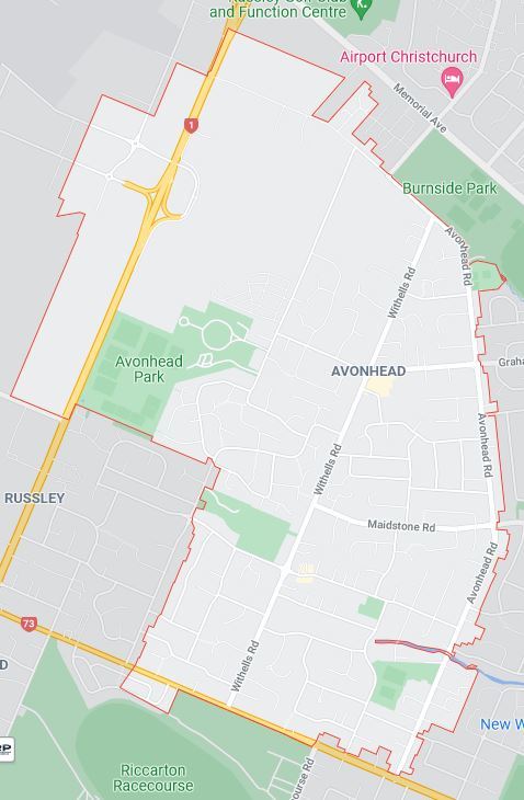
Map Data ©2022 (image from Google Maps)
Neighbouring suburbs: Christchurch Airport, Burnside, Ilam, Sockburn, Broomfield, Russley and Yaldhurst.
Avonhead is another north-western suburb that was developed post-war in what was then Waimairi County. It was developed a bit later than suburbs to its north such as Burnside and Bishopdale, with the council only officially naming the suburb Avonhead in 1959. The name Avonhead had been around since the 1850s. Avonhead was the house built by William Bayley Bray, who arrived on the first four ships in 1851 (Avonhead was the first house built after the ships arrived). The house was located where Archdall Place is today (the published coordinates are at the end of Archdall Place). Bray bought rural sections 177, 178 and 179, which make up a lot of the modern suburb of Avonhead. Based on old maps, I think the modern roads that form the boundary of this area are Avonhead Road, Hawthornden Road, Merrin Street, Withells Road and Yaldhurst Road. Another early name for the area was Avonwood, but I suspect there wasn't much of a wood left by the late 1950s.
Bray chose the name because his land contained the headwaters of a number of the streams that make up the Avon River. A couple of branches of the Waimairi Stream crossed Avonhead Road just south of Burnside Park (not sure if anything is still visible above ground today west of Avonhead Road). One of these branches is visible east of Avonhead Road, where it divides the Bowling Club from Burnside Park. Ilam stream flows through Crosbie Park (home of WP3), and disappears underground at Aspley Drive. The Avon itself crosses Avonhead Road and Balrudy Street (location of WP4), before disappearing underground before it reaches Norton Rd. The original source of the Avon was in the neighbouring suburb of Russley, or possibly on the other side of Russley Road in Yaldhurst.
Avonhead is still on the outskirts of the city, with areas of farm paddocks along parts of Hawthornden Road and Russley Road. The area of paddocks is being whittled away. A large Summerset retirement village is under development on Hawthornden Road. A small area of Avonhead extends beyond Russley Road, and some of that area is within the Dakota Park development, Christchurch Airport’s 80-hectare freight and logistics precinct. The main shopping area in the suburb is the Avonhead Shopping Centre. As with Bishopdale Village Mall, the Avonhead Shopping Centre was developed in the 1960s within the Waimairi County Council area, but unlike Bishopdale it was developed by a private developer. There are two primary schools in the suburb (Avonhead and Merrin) and quite a few parks, the main ones being Avonhead, Crosbie and Ferrier. The suburb also contains the Avonhead Memorial Cemetery (the name was changed to include Memorial in recent years following the creation of a Memorial Garden for unfound earthquake victims). The cemetery opened in 1983, and is still open for burials. Given the timing, I imagine that Waimairi County Council established Avonhead Park Cemetery (as it was then) as a result of Waimairi Cemetery (opened a few years after the county was created) nearing capacity.
You will need to visit four waypoints to work out where the cache is hidden.
- WP1 is in the aforementioned memorial garden. From the WP, look at the monument at the centre of the garden. You will see a plaque on the side of the monument. D = number of letters in the last word of the second line.
- WP2 has a couple of plaques commemoriating something somewhat relevent to geocaching. I remember when this object was on Russley Road (along with a yellow AA sign saying "Historic place"). It seemed a dodgy place to stop before Russley Road was four-laned; no surprise it was moved. BC = last two digits on the plaque on the ground.
- WP3 is one of 50+ water wells in Christchurch city. It is close to Ilam Stream. You need to locate a horizontal silver plate attached to the top of a blue fitting (knee height, in enclosure). A = middle digit in the 5 digit number on the plate.
- WP4 is the last place the Avon crosses a street (above ground anyway). Find a round disc on the lamppost (waist-ish height). Note the four digits on the last line. E = sum of first and third digits. F = fourth digit.
Final: S 43 31.ABC E 172 33.DEF
Checksum of A to F: 37.
Cache is pill bottle hanging from a cable tie at head-ish height. There are obvious metal items at ground level at GZ (about 12 paces apart). Stand with the southernmost of the two behind you and peer into the foliage.