
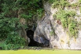
Getting to the caves: You could once stroll right up to the cavern in dry summers, but the pond today requires explorers don ice skates, snow shoes, or metal tracks and visit in winter. Take the path down from the Arthur Park trailhead along North Ave, and descend to the edge of the pond. From there, if safe, you can traverse the ice to reach the caves along the wall of the bluff.
Intervale Sea Caves History, quoted from Sean Beckett and Samantha Ford:
“For thousands of years, Native American communities farming, fishing, and inhabiting the Winooski River’s Intervale took advantage of the Sea Caves’ natural shelter. The moderating temperatures and protection from the prevailing wind made the site a perfect meeting location and storehouse. In the winter, families congregated in the caves to find a warm retreat from the season’s most bitter temperatures. In the summer, the caves were a favored storehouse for goods like dried fish and corn, critical commodities traded by the local Winooskiok Abenaki community.”
Formation: The sea caves seen here are no longer in contact with the ocean, instead sitting many miles inland. Back in the day, even before the age of dinosaurs, current-day Burlington and surrounding areas were all under water of the lapetus Ocean. Sediment and other material slowly settled to the ocean floor, and compressed under the pressure of the water into the limestone we see today. Much later, roughly 11,000 years ago, this area was covered by the Champlain Sea. It sat about 100 feet higher than the current Lake Champlain, with the Winooski River much wider than it is today. After the sea receded to its present-day level, the Winooski River meandered all around, carving and finding its way along the former delta. Part of its course hugged the Arthur Park hillside, until it once again diverted to its current path.
Littoral caves are formed by erosion of the rock caused by the ocean and rivers (like the Winooski River). The constant movement of the waves and currents wear away, channeling through the rock, forming caves and tunnels. Some caves have been formed by other means, such as acidic breakdown, but are not considered littoral caves. If water then fills the cavern, Littoral processes may continue the erosion and wear. The caves can form within any of the three (igneous, metamorphic, and sedimentary) types of rock. Usually the first two types of rock are home to larger caves. This is because they are naturally a stronger rock. Thus, sedimentary rock collapses more easily, allowing only smaller caves to develop. The actual formation of the caves can be attributed to weak spots in the rock itself.
How do weak spots come to be?
Weak spots in the rocks are usually faults or dikes (dikes are slabs of rock that crack and protrude from a slab of pre-existing rock). In sedimentary rock, weak spots can also be caused by meeting points of rock of different hardness. The erosion process is magnified at the point of weakness because rock is removed at a greater rate. This causes the caves to form. The water works its way into small cracks and natural fissures and pocket, and slowly erodes the rock. The weak becomes weaker, removing more and more rock along the weak spot(s). Eventually, sizable caves form and may even create tunnels. If the rock is too weak to support itself over the littoral cave, it may collapse, causing a littoral sinkhole. These sinkholes, if caused while a whole tunnel is present, can even split the small island in half. There is also other forces to create sea caves. Acidic compounds can eat away at rock. Rainwater, slowly but surely, can erode rock, creating tunnels and caves. Lastly, the enlargement of sea caves can be furthered by the presence of living creatures. Sea urchins, for example, drill into the rock, which over time can break off chunks of the stone.
To log this Earthcache, please send me a note with the following upon return from your adventure:
- The name of this earthcache and the number of people in your group
- Lets assume all the rock along this cliffside is the same type. Why aren’t there caves forming at every available location?
- While in the cave, can you identify any irregularities in the rock surfaces (cracks, large holes, convergance of two separate rock layers) that would help explain why this cave was formed? Describe any irregularities you may find.
- As you stand in the cave, you may notice liquid (or frozen!) water coming forth from the ceiling. Describe relatively where in the cave you found water coming down from above, and explain where you think this water is coming from. Is this water source still contributing to the cave formation processes?
Feel free to post pictures with your log, and stay safe!
Sources:
https://enjoyburlington.com/arthur-park/
http://www.lilburnes.org/Students/Caves/sea_caves_ivanna.htm
http://en.m.wikipedia.org/wiki/Dike_(geology)
http://en.m.wikipedia.org/wiki/Sea_cave
https://medium.com/curious/behold-the-devils-den-13a56f0e9862