
Multicache:
Dette er en geocache der du må mer enn et steg før du er framme ved sluttkoordinatene for geocachen. Oppgaven er beskrevet i teksten under.
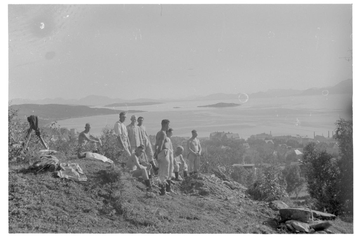
Stillingen på Harstadåsen
Narvik var et klart mål for tyskerne under invasjonen nordpå. Men innseilingen gjennom Ofotfjorden mot Narvik mente tyskerne var risikabel. Angrepsplanene på Norge ble laget av Nikolaus Von Falkenhorst, som ikke kjente landet, og som måtte benytte en reisehåndbok i sin planlegging. Tyskerne hadde informasjon om at det lå kystbatterier langs Ofotfjorden som kunne forsinke, og i verste fall stoppe den planlagte erobringen av Narvik. Sannheten var derimot noe annet; disse fortene var påbegynt og planlagt etablert etter første verdenskrig, men aldri fullført.
For å erobre de norske batteriene ble derfor tre av ti jagere satt i oppgave med å frakte bergjegere som skulle gå i land og nedkjempe fortene. Før de så skulle bruke kanonene i batteriene mot de engelske krigsskipene de regnet med ville komme etter når de hadde inntatt Narvik. Først 9. april, etter at to jagere hadde satt av sine bergjegere, oppdaget de at batteriene ikke eksisterte.
Usikkerheten i planleggingsfasen gjorde at tyskerne måtte tenke ut en reserveplan. Harstad og Gratangen ble tatt ut. Gratangen på grunn av sin geografiske beliggenhet, og Harstad fordi de visste at det var her general Fleischer og 6. divisjonsstab hadde hovedkvarter. Og klarte de å sette generalen og hans stab ut av spill så regnet de med at de klarte å passifisere de norske hærstyrkene i Nord-Norge.
Tre jagere fikk jobben med å ta Harstad. De skulle landsette bergjegere på Trondenes som skulle rykke inn mot sentrum og besette de militære bygningene, havna, telegrafbygget, postkontoret og viktige veier. De skulle også opprette kontakt med general Fleischer for å etablere et samarbeid, om mulig. Alle norske soldater i byen skulle avvæpnes. Planen hadde også fokus på at operasjonen ikke skulle forstyrre hverdagen til innbyggerne i byen.
Skulle derimot det norske militæret sette seg i motverge, var planen at bataljonssjefen skulle ta sine avdelinger og tunge våpen opp i høydedragene over byen til Harstadåsen. Herfra hadde de god utsikt og oversikt over byen. Herfra kunne de hindre eventuell fiendtlig landgangs forsøk etter at tyskerne hadde okkupert byen.
Reserveplanen ble aldri tatt i bruk og det ble dermed ingen ilandsatte soldater i Harstad den 9. april. Tyskerne kom først til Harstad etter at de allierte hadde forlatt i juni 1940. Kystbatteriene rundt Harstad som bare var påtenkt ble i etterkant bygget av tyskerne i løpet av krigsårene. Det ble også etablert stillinger her oppe på Harstadåsen.
Kilde: Harald Isachsen
Oppgaven:
For å komme fram til geocachen må du oppsøke de oppgitte koordinatene, og der finne ut av følgende:
Hvor mange byggverk ser du i terrenget rundt deg der du står på nullpunktet?
Dersom 2 er riktig svar gå til N 68° 48.162 E 16° 31.553'
Dersom 3 er riktig svar gå til N 68° 48.120' E 16° 31.513'
Dersom 4 er riktig svar gå til N 68° 48.170' E 16° 31.440'

Multicache:
This is a multicache where you will have to find the answer to the question at the first step to solve the coordinates to the final geocache.
Military stand on Harstadåsen
Narvik was a primary target for the Germans during the invasion of the north. The plans for the attack on Norway were made by Niklaus Von Falkenhorst, who had never been to Norway, and who had to use a travel guide when planning. The Germans had information that there were coastal artillery batteries along the Ofotfjord that could delay, or in the worst case end the planned conquest of Narvik. The truth, however, was that these batteries were planned to be established but were never built.
In order to conquer the Norwegian artillery batteries, three out of ten destroyers were therefore given the task to transport soldiers that would go ashore and defeat the batteries. Afterwards they would use the batteries against the English ships they reckoned would arrive after they conquered Narvik. But it was not until after two of the destroyers had put their soldiers ashore, on April 9th, that they discovered that the batteries did not exist.
The uncertainty in the planning phase meant that the Germans had to have a plan B. One plan was to go ashore in Gratangen because of its geographical location. Another was to conquer Harstad, since they knew that General Fleischer and the 6th Division staff had their headquarters there. They reckoned that if they managed to put the general and his staff out of action, they would easily manage to pacify the armies in northern Norway.
Three destroyers were set to bring soldiers to Trondenes. From there they would move to the city center and occupy the military buildings, the harbor, the telegraph station, postal office and important roads. They would also establish contact with General Fleischer, to attampt to establish a collaboration with him. It was also important that this was done without disturbing the everyday life of the city inhabitants.
Should, on the other hand, the Norwegian military take a stand, the plan was for the battalion commander to take his units and heavy weapons up the ridges over the town to Harstadåsen. From here they had a good overview of the city, and could protect the city and prevent any enemy landing attempts after the Germans had occupied the city.
Plan B was never taken into action, and no soldiers came to Harstad on April 9th. The Germans came to Harstad after the Allies had left in June 1940. The coastal batteries around Harstad were subsequently built by the Germans during the war. That also includes the stand here on Harstadåsen.
Source: Harald Isachsen
Task:
To get to ground zero of this geocache, you have to visit the given coordinates and answer the following question:
How many constructions can you see in the terrain around you?
If 2 is the right answer go to N 68° 48.162 E 16° 31.553'
If 3 is the right answer go to N 68° 48.120' E 16° 31.513'
If 4 is the right answer go to N 68° 48.170' E 16° 31.440'
Velkommen til GeoTour 68°N (GT4BD)!
Dette er en serie med 12 geocacher plassert i Harstad og Narvik med omegn. Serien har som formål å vise fram noen av de sporene som 2. verdenskrig etterlot. Både der du kan se noe i terrenget, og noen av historiene fra området. Dersom du lokaliserer alle 12 cachene vil du få et lite innblikk i hvordan krigen påvirket området.
Samtlige av cachene skal være forholdsvis enkle å lokalisere. Du vil med denne serien også få et godt innblikk i geocaching, og noen av de ulike typene geocacher (både tradisjonell, multi, wherigo og letterboks er inkludert i denne serien).
I samtlige av cachene finner du et hullstempel til å bruke i passet ditt. Dersom du ikke allerede har et pass så kan dette lastes ned og printes herfra: Pass
NB! Det er viktig at loggbok og hullstempel ikke fjernes fra cachene!
Oversikt over GeoTour 68°N og cachene som serien består av kan du finne her:
Geotours oversikt
Denne GeoTouren vil få følge av en ny GeoTour i 2023, og en annen i 2024. Geocachene i alle tre seriene vil arkiveres i slutten av oktober 2025.
Lykke til! Vi håper du får en fin opplevelse, og får utforsket Harstad og Narvik med omegn på en ny måte!
Del gjerne din opplevelse med oss i sosiale medier med #GeoTour68N, #halogeo and #68nord!
Welcome to GeoTour 68°N (GT4BD)!
This is a series of 12 geocaches placed in and around Harstad and Narvik. The purpose of the series is to show you some of the remnants that the second world war left behind. It will showcase remnants you can see something in the terrain, and stories from the area.
All of the geocaches should be relatively easy to locate. You will with this series get a good insight in to geocaching and some of the different types of geocaches. The series includes traditional, multi, wherigo and letterbox.
In all the geocaches you will find a hole puncher to use in your passport. If you haven’t already got a passport you can download and print it here: Passport
NB! It is important that you do not remove the logbook or holepuncher from the geocaches.
An overview of the GeoTour 68°N and the caches it includes you can find here:
Geotour overview
This GeoTour will get company by an additional GeoTour in 2023, and another one in 2024. The caches in all three GeoTour will all be archived in the end of October 2025.
Good luck! We hope that you will enjoy our GeoTour, and that you get to explore Harstad and Narvik with its surroundings in a new way.
We would love to see your experience shared in social media with #GeoTour68N, #halogeo and #68nord!