Picton (Waitohi) is a town in the Marlborough Region of New Zealand's South Island. The town is located near the head of the Queen Charlotte Sound/Totaranui, 25 km (16 mi) north of Blenheim, and 65km (40mi) west of Wellington. Waikawa lies just north-east of Picton and is considered to be a contiguous part of the Picton urban area.
Picton is a major hub in New Zealand's transport network, connecting the South Island road and rail network with ferries across Cook Strait to Wellington and the North Island. The Picton urban area has a population of 4,790 (June 2021), making it the second-largest town in the Marlborough Region behind Blenheim. It is the easternmost town in the South Island with a population of at least 1,000 people.
The town is named after Sir Thomas Picton, the Welsh military associate of the Duke of Wellington, who was killed at the Battle of Waterloo.
Thomas Picton's connection to the slave trade and controversial governorship of Trinadad has resulted in calls for places named after him to be renamed.
The town's Maori name, Waitohi, translates into English as 'waters of the tohi ritual'. The tohi is a baptismal ritual of warriors before they went into battle. The warriors would line the bank of the sacred stream, and as they filed past, the tohunga (chosen experts) dipped a branch of karamu bush into the stream, striking each warrior on the right shoulder. The tohi rite was last performed on soldiers of the 28th Maori Battalion during World War II.
History
Prior to European settlement, the Te Atiawa o Te Waka-a-Māui iwi occupied Waitohi Pā on the site of the present town. In March 1850, Sir George Grey and Sir Francis Dillon purchased the land from Te Āti Awa, who moved to neighbouring Waikawa Bay. In 1859, the Marlborough Province was created and the newly named Picton became the provincial capital. The provincial capital was moved to Blenheim in 1865.
Author Katherine Mansfield spent time in Picton, where her grandparents, Arthur and Mary Beauchamp, and her father Harold, lived for some time when they came from Australia. She included a reference to the port in her short story "The Voyage" (in the collection The Garden Party), which is "an account of a trip to Picton from Wellington on the Cook Strait ferry".
The roll-on/roll-off (RORO) road and rail ferry service between Picton and Wellington started on 11 August 1962, operated by the New Zealand Railways, now known as Kiwi Rail. Since 1992, StraitNZ has added the Bluebridge Ferry service to the inter-island route.
Geography
Picton is located in an inlet known as Picton Harbour, on the true right (south) side of the upper Queen Charlotte Sound/Tōtaranui. Picton Harbour is flanked to the west by Wedge Point, which separates it from Grove Arm, and to the east by The Snout, which separates it from Waikawa Bay. Within the harbour, Kaipupu Point splits the inlet into two, Picton Harbour proper to the east and Shakespeare Bay to the west.
The main town is located on flat to rolling land at the head of Picton Harbour. Waitohi River starts in Essons Valley and passes through the town, draining into the sound near the ferry terminal. The township extends northeast along rolling land towards Waikawa Bay, separated from Picton Harbour by The Snout and Victoria Domain.
On the land side, Picton is surrounded by hills and mountains, including Te Tara-o-Te-Marama/Mount Freeth to the west, the Robertson Range to the south and Mount McCormick to the east. The Elevation Saddle connects southwest of the town with the Tuamarina River valley and contains the main land transport routes between Picton and the rest of the South Island.
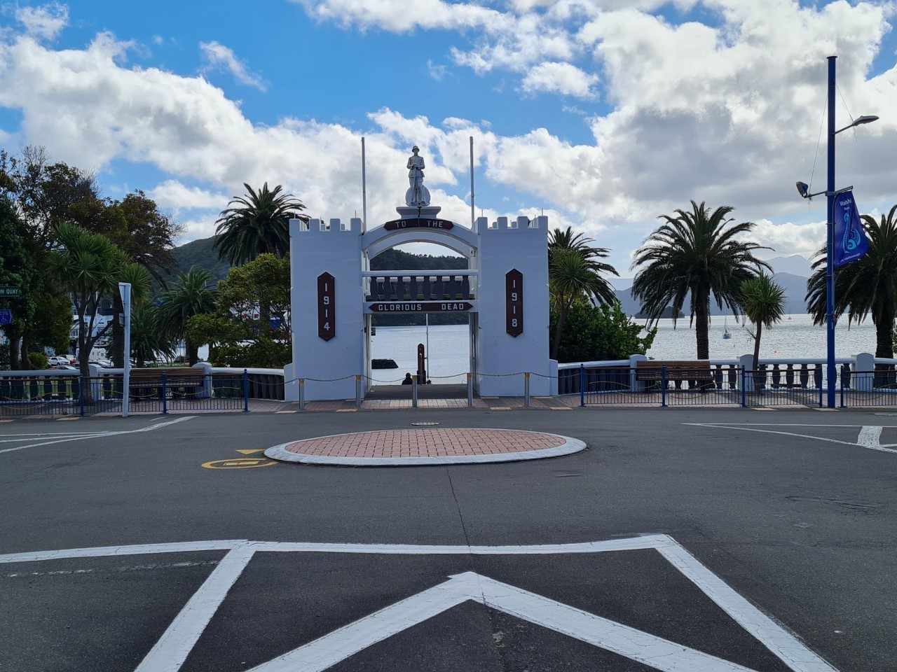
To log this cache you need to do two things:
Firstly, take a photo from the listed coordinates which attempts to duplicate the one taken by the CO depicted above. Bonus points if you can get an arriving or departing inter-island ferry captured in the archway. Post this image along with your 'Found' log.
Secondly, go to WP1 and look down at the ground below the plaque that lists the names of those who did not return from WW1. There you will see a light embedded into the concrete that lights up the plaque at night. At the end of the light there is a four lettered code formatted 'ab-cd'. Send this code to the CO using the Geocaching email or message link provided on the CO's profile page. DO NOT post this code with you 'Found' log.
You may log your find at any time without receiving permission from the CO. However, if the required photo has not been included with your log, or the required code not been sent to the CO within seven days of posting the find, your log will be removed.
This Virtual Cache is part of a limited release of Virtuals created between March,2022 and March 2023. Only 4,000 cache owners were given the opportunity to hide a Virtual Cache. Learn more about Virtual Rewards 3.0 on the Geocaching Blog.