Sahanlahti, Puumala
Kruununvouti Johan Meinander perusti maakunnan ensimmäisen vientisahan omistamansa Partalan rusthollin maille Miettulaan vuonna 1765. Saha tunnettiin Miettulan tai Puumalan sahana ja sen säännöllinen toiminta pääsi käyntiin 1770-luvulla. 1830-luvulla saha siirtyi viipurilaisen Hackmanin kauppahuoneen omistukseen, jolloin vanhat laitteet ja rakennukset purettiin, ja koko laitos rakennettiin uudestaan vuonna 1838. 1850 sahan omistajaksi tuli Paul Wahl & Co, jolla oli muitakin sahalaitoksia, ja joka harjoitti myös telakka- ja konepajatoimintaa. Sahan yhteyteen rakennettiin mylly ja vuonna 1876 yksiraaminen höyrysaha.
Suurimmillaan saha oli 1800-luvun lopulla, jolloin työntekijöitä oli lähes 50. 1900-luvun alkupuolella työntekijöitä oli taasen kuudesta seitsemään; kaksi miestä raamilla, kaksi purunajajaa, uittaja ja mylläri. Saha pyöri kahdessa vuorossa ja työpäivä kesti kymmenen tuntia. Yhden tukin sahaaminen vei nelisen minuuttia.
Vuonna 1910 sahan osti suomalainen suuryritys, joka aloitti toiminnan alasajon, ja 1920-luvun alkupuolella sahalaitos suljettiin. Viimeinen saha purettiin vuonna 1936.
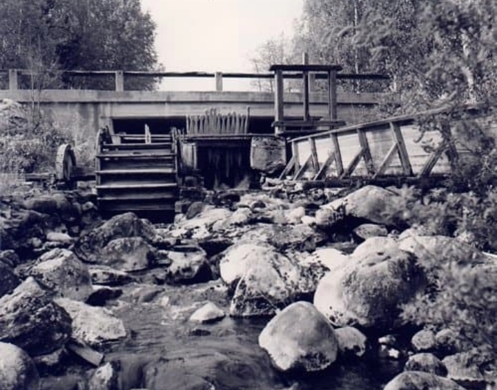
Vanha vesisaha sijaitsi aluetta halkovassa koskessa, jossa on edelleen nähtävissä raunioiden lisäksi vanha uittoränni. Sahatyöläisiä asui aikanaan yhdyskuntana kosken molemmin puolin mökeissä, kaksi perhettä mökissään. Alkuperäisistä työläisten asuinrakennuksista on vielä jäljellä museokäytössä oleva talo pihapiireineen ja kosken länsipuolella sijaitseva Jallun tupa. Sahanvalttarin eli sahanhoitajan talo toimii nykyisin matkailuyrityksen päärakennuksena.
Jääkauden jäljet Sahanlahdessa
Jääkauden kuljettamia siirtolohkareita on nähtävissä Sahanlahden ympäristössä ja yhden lohkarekasauman löydät virtuaalikätkön kuvauskohteista. Noin kilometrin päässä sijaitseva Tupavuoren kalliossa oleva lohkare- ja rakoluola on myös jääkauden aikaansaannosta, Saimaa Geoparkin opaste luolasta on kätkön parkkikoordinaateissa.
TEHTÄVÄ:
Käy boguksessa sekä kahdessa reittipisteessä ja ota kuva joko itsestäsi (kasvojen ei tarvitse näkyä) tai jostakin mukanasi tuomasta esineestä. Kuvassa tulee näkyä myös kyseiset kohteet (puhelinkoppi, koski sekä lohkareet ja kyltti "Elsa Heporaudan polku" (kyltti esimerkkikuvan ottamisen jälkeen uusittu)). Yhteensä kuvia tulee siis olla kolme (3), liitä ne loggaukseen. Loggaukset ilman kolmea kyseistä kuvaa tullaan poistamaan.
Esimerkkikuvat liitteenä.
Olethan varovainen liikkuessasi liukkaalla säällä kosken luona portaissa!
ENGLISH:
Johan Wilhelm Weinander, the tax collector, established the first export sawmill on the Partala estate lands in Miettula in 1765. The sawmill was known as the Miettula or Puumala sawmill, and it started operating in 1770's. In 1830's the sawmill was acquired by the Hackman Trading Company, and the old equipment and buildings were dismantled and the sawmill was re-built in 1838. In 1850 the sawmill was acquired by Paul Wahl & Co, who also owned other sawmills and had shipyard and engineering businesses. A mill was built by the sawmill at the time and a steam-powered frame saw in 1876.
The heyday of the sawmill was at the end of 1800's, when it employed almost 50 workers. In early 1900's there were six to seven employed: two men on the frame saw, two men gathering sawdust, a floater and a miller. The sawmill ran in two shifts and the working day lasted 10 hours. The sawing of one log took about four minutes.
In 1910 the sawmill was acquired by a large Finnish company, which started to close down the operations and in early 1920's the sawmill was closed. The last part of the sawmill was dismantled in 1936.
The old water sawmill was in the rapids running through the area, and one can still see its ruins as well as an old log chute. The sawmill workers and their families lived in cottages built on both sides of the river, two families per cottage. What remains of the original settlement is the current museum with its courtyard as well as the "Jallun tupa (Jallu's cottage)" on west bank of the rapids. The house of the sawmill steward is now the main building of the resort.
The traces of the Ice Age in Sahanlahti
One can still see the erratic boulders brought here by the glaciers of the Ice Age, one of the boulder groups is a photo location for this virtual cache. About one kilometer from Sahanlahti there is a glacial erratic cave which is also a result of the Ice Age. A Saimaa Geopark info about the cave is in the cache parking coordinates.
YOUR TASK:
Go to the bogus point as well to the two waypoints and take a picture of yourself (your face doesn't need to show) or something that you brought with you. The pictures must include the required waypoints (phone booth, the rapids and glacial erratics + sign "Elsa Heporaudan polku" (the sign has been renewed after the exemplary picture was taken)). So you need to attach three (3) pictures into your log. Logs without three pictures will be removed.
You can see the exemplary pictures attached.
Be very careful when you walk the steps close to the rapids, when it is slippery!
Käännösavusta kiitos SonofSurfbird ja Tommi.
Lähteet/resources:
Etelä-Savon kulttuuriperintökanta (http://esku.fi/asp/alue_det.aspx?ALUE_ID=10322)
Jaana ja Janne Kuivalainen
Saimaa Geopark opastaulu (https://saimaageopark.fi/wp-content/uploads/2019/02/geopark_opastaulut_sahalahtilinnavuori_1806_web.pdf)
Virtual Rewards 3.0 - 2022-2023
This Virtual Cache is part of a limited release of Virtuals created between March 1, 2022 and March 1, 2023. Only 4,000 cache owners were given the opportunity to hide a Virtual Cache. Learn more about Virtual Rewards 3.0 on the Geocaching Blog.