This is an Earth cache, so there is no container hidden at the coordinates.
To claim credit for this cache, read the text below, visit the given coordinates and email me answers to the questions in the logging requirements at the end of this listing.
Accessibility
The Earth cache is placed in the Dora Kelley Nature Park. Respect the park's opening hours, this cache is daylight only and no night caching. Follow the park rules and mind the nature: This is a protected area where rare plants grow and "leave-no-trace" is required. Permission has been granted to place this cache provided there will be no harm to the local flora.
Limited, but free parking is available at Chambliss Park. From here, follow the footpath heading East until you reach Leverett Ct. Walk down to WP1 at N38 49.968 W77 07.712 and turn to the west. This is the shortest&easiest walk with terrain rating 1.5-2 that will bring you to the upper bank of the confluence right above GZ.
Ground Zero
To access the GZ you'll need to descend from the upper bank to the stream, which means negotiating some rocks and concrete blocks, so wear good hiking shoes. Please, use your best judgment - this area might be very slippery and muddy, especially on or after a rainy day. Don't walk on the hanging edges of the banks as these are eroded from below - see the trees hanging onto their dear life, you don't wanna be in their place! Some mosquito activity has been reported.
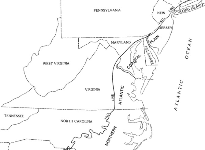
The Fall Line
The goal of this listing is to take you on a journey through the geologic history of Alexandria and explore a significant geologic feature. The coordinates are located in the Dora Kelley Nature Park, which is a part of the fall line: a zone where two geologic provinces meet and grind at one another in a process that has been ongoing for millions of years and shaped the location of major Virginia's cities, including Alexandria. The last eastern exposure on the surface of the Piedmont bedrock is zone of waterfalls and rapids known as the Fall Line. Nowadays, Interstate 95 can be a rough guide to the location of the geologic boundary separating the soft sediments of the Coastal Plain province from the hard bedrock of the Piedmont province.
Piedmont Geology - West of the Fall Line
The hard crystalline bedrock between I-95/I-85 and the Blue Ridge was created between 250-450 million years ago in the tectonic collisions that formed the supercontinent Pangea. The metamorphic and igneous formations of the Piedmont are buried below the soft sediments of the Coastal Plain, and continue all the way from the Blue Ridge to the edge of the Continental Shelf in a depth of about 10,000 feet.
Chunks of silica-rich crust, eroded sediments that accumulated on the ocean floor, and basalt ocean crust along with mud, sand and soft sediments were compressed, metamorphosed and pushed into Virginia, thus making it wider. Interestingly, Virginia also got thinner as compression during orogenies (orogeny = forming of a mountain range by Earth's crust being compressed and folded) cracked the bedrock and thrust blocks on top of other blocks, stacking the bedrock while reducing the distance they once covered.
After Pangea split up, the 20,000 feet high mountains eroded away over 250 million years to expose the Piedmont's bedrock. The current Blue Ridge was once buried deeply beneath the overlying material pushed up in the Alleghenian Orogeny. The Blue Ridge has been exhumed later as water and wind have carried away the overlying material.
Coastal Plain Geology - East of the Fall Line
East of the Fall Line, the ground exposed at the surface consists of sediments that are younger and softer than the Piedmont bedrock. Much of those sediments in the Coastal Plain eroded off of the ancient Appalachian Mountains as for the last 300 million years, rain and wind has etched away those mountains, carrying sand and mud towards the Atlantic Ocean. All of eastern Virginia was covered with those sediments when sea level was high enough. At low stands, such as the recent Ice Age when water was locked into ice sheets and sea level was 400 feet lower, rain and wind carved into the sedimentary deposits. The sediments were carried away again, ultimately exposing the hard crystalline bedrock to create today's Piedmont.

The map shows the formations in the Holmes Run Gorge in Alexandria West. The Dora Kelley Nature Park is located in the upper right quadrant. The fault is marked with a black vertical line with a small triangle and number 80, which indicates the dip in degrees. Letters U and D stand for upthrow and downthrow respectively. Upthrow refers to an upward displacement of rock on one side of a fault, downthrow is the opposite.
A geological formation is a body of rock with a consistent set of physical characteristics that distinguishes it from adjacent bodies of rock, and which occupies a particular position in the layers of rock exposed in a geographical region.
Potomac Formation (Kp) is one of the units of Coastal Plain, formed in the early Cretaceous period. It consists of clay, silt and gravel. This is a primarily subsurficial unit, meaning it's hidden underground, except for outcrops. An outcrop is a visible exposure of bedrock on the surface of the Earth caused by weathering and erosion.
Indian Run Formation (OCi) is a unit of the Piedmont bedrock and is of Cambrian and early Ordovician age. Contains diamictite, Accotink schist, sandstone and quartz lumps.
A fault
Rocks react to physical forces, such as pressure and heat, by breaking. If there is no offset along either side of the break, this is called a fracture or a joint. A fault is a fracture between two rock structures, which allows these rocks to move in relation to one another. There are four types of faulting - normal, reverse, strike-slip, and oblique.
A normal fault is one in which the rocks above the fault plane, or hanging wall, move down relative to the rocks below the fault plane, or footwall.

A reverse fault is one in which the hanging wall moves up and over the footwall. Fault motion is caused by compressional forces and results in shortening as the two blocks move against one another. A reverse fault with gently inclined fault planes (dip angle <45°) is referred to as the thrust fault. If the dip angle of the fault plane is low (often less than 15 degrees from the horizontal) and the displacement of overlying rock is large then the fault is called an overthrust fault. In the case of reverse/thrust fault, the vertical force is smaller compared to the horizontal compressive forces.

When rocks on either side of a nearly vertical fault plane move horizontally, the movement is called strike-slip. An oblique-slip fault is special type fault that forms when movement is not exactly parallel with the fault plane. Oblique movement occurs when normal or reverse faults have some strike-slip movement and when strike-slip faults have either some normal or reverse movement.

Dora Kelley Fault
This small reverse fault is exposed in a steep natural cut on the south bank of the ravine that runs through Chambliss Park and Dora Kelley Nature Park, about 10 feet downstream of the confluence of two forks of the ravine. The lowermost several feet of the Potomac Formation on the East side of the fault consists of coarse, thoroughly weathered gravel with green silt. Fault lines with arrows mark the fault walls and its sense of motion respectively: downthrow on the East side, upthrow on the West. Yellow line shows the bedrock surface on the Indian Run Formation towards West.
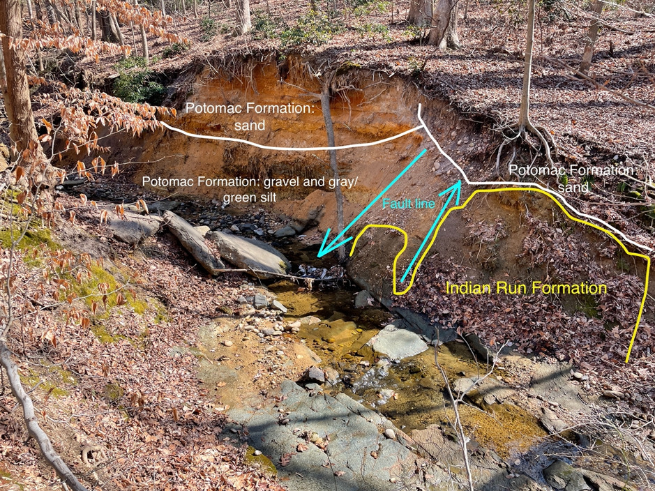
Right at the confluence, the bank right has an interesting sequence, with an irregular surface on saprolite overlain by 2-4 feet of extremely coarse, intensely weathered cobble gravel in a sandy clay matrix. Above the gravel, several beds of sand extend to the top of the bank, with a disrupted bed silty clay.

Logging requirements
All of the following are required to claim a find. Send your answers within 3 days of logging the cache and include the photo with your log. If I do not receive your answers, I will reach out to you. Should you fail to provide the answers following my request, your log will be deleted.
Requirement 1: Would you say that orogeny is a linear process? Explain your thoughts.
Requirement 2: Examine the fault at the coordinates. Name the two geologic provinces that are involved in the Dora Kelley NP fault. Which of these bodies of rock is older?
Requirement 3: Climb down from the high bank to stand right at the confluence. Some rock hopping might be needed, but this is easily accessible without getting wet. Look in the direction of 200 degrees southwest.
a) How high is the bank in front of you, in your estimation?
b) Describe the structure, texture and colour of the layers you can see. Is it wet or dry?
c) The clay in the wall is of two distinct colours, what are those?
Requirement 4: Take a photo of yourself/your gpsr/personal object that shows the white clay to your left. Post this photo with your log.
I hope you enjoyed the cache and am looking forward to your adventure log :)
Sources:
The inspiration was acquired from the sources listed below.
I am grateful to the geologic research done by Tony Fleming, based on his reports I was able to do my own amateur survey, take photos and put together this listing.
www.alexandriava.gov/parks/basic-page/geology
US Geological Survey
Virginia Geologic Map Data
Congratulations to:
FTF: kiisikwa
STF: zgrav
TTF: Team Palazzo