PR-CV-59 II – RUTA CIRCULAR GEODESICO DE ORIHUELA

Esta serie de 25 cachés tiene por objetivo realizar una ruta circular de montaña lo largo de la Sierra de Orihuela, con inicio y final en la Urbanización Pinar de Bonanza, visitando el punto geodésico de la Sierra de Orihuela y el Paso del Gato, donde confluye con la otra serie de caches de esta ruta PR-CV-59 siendo el caché #21 común a ambas series. Para ello seguiremos en la mayor parte del recorrido la Ruta PR-CV-59-II. La senda discurre por caminos y veredas delimitadas y balizadas con pintura. Espero que disfrutéis de vistas absolutamente espectaculares.
ATENCION: Se trata de un recorrido de dificultad media, fisicamente algo exigente y es preferible tener cierta experiencia en la montaña, no siendo necesario equipamiento especial. NO ES APTA para menores de 8 años ni recomendable para personas con problemas respiratorios o cardiovasculares.
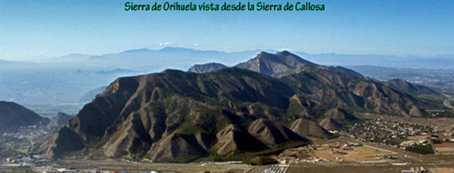
LA SIERRA DE ORIHUELA
La Sierra de Orihuela es una alineación montañosa situada entre el límite meridional de la provincia de Alicante y el extremo oriental de Murcia. Pertenece a la comarca del Bajo Segura, en particular a los términos municipales de Orihuela y Santomera.
La Altura Máxima es de 634 m. de altura en su punto máximo. Algunos de sus picos son la Muela, Pico de la Cruz de la Muela (564 m.), Pico del Cuervo, Pico del Águila(634 m.).
Geológicamente, se encuentra enclavada dentro del dominio bético. Junto con la sierra de Callosa forma una alineación montañosa compuesta por bloques de calizas dolomíticas del triásico, que emergen aisladas en medio de la llanura aluvial. Sus formas son abruptas y muy fragmentadas.3 Desde la antigüedad, estos montes han sido objeto de la actividad minera, siendo frecuentes los pozos y galerías que todavía podemos encontrar. Fundamentalmente, junto con algunas explotaciones de yesos y calizas abandonadas en la actualidad, se extraían minerales de hierro y en unos pocos lugares oro nativo.
Toda la sierra presenta numerosas oquedades, abrigos y cuevas de desarrollo variable, lo que le confiere al abrupto paisaje una cierta singularidad y belleza geomorfológica.
Hidrológicamente, toda la zona está sometida a una elevada insolación en los meses de verano. Este factor, junto con las escasas precipitaciones, dificulta la existencia de fuentes y cursos de agua permanentes. Tan sólo la fuente de San Cristóbal puede contener algo de agua tras lluvias importantes.
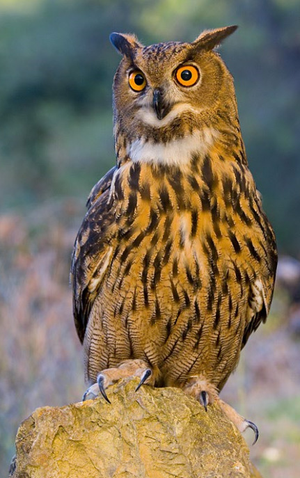
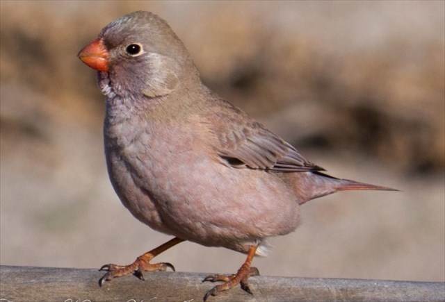
En cuanto a la fauna, las aves son el grupo mejor representado, destacando la presencia del águila perdicera (Hieraetus fasciatus) y águila real, especies gravemente amenazadas y que nidifican en la zona, búho real (Bubo bubo), el búho chico (Asio otus), cernícalo vulgar (Falco tinnunculus), gavilán (Accipiter nisus) y el halcón peregrino (Falco peregrinus). En las formaciones de cornial albergan aves raras como el camachuelo trompetero (Bucanetes githagineus) y la carraca (Coracias garrulus).
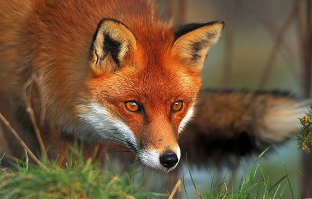
Entre los mamíferos cabe destacar la presencia del del zorro, el gato montés (Felis sylvestris), la cabra montesa y la liebre.
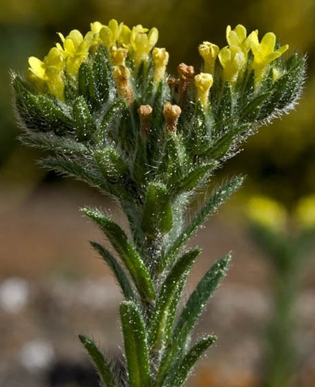
La flora es una de las variables biológicas más notables del ecosistema que alberga esta Sierra, no sólo por la gran cantidad de especies que la pueblan, entre los que destaca el Rabo de gato ceniciento (sideritis glauca) y el Cardo de roca (Centaurea saxícola) que aparecen abundantemente en las sierras de Callosa y Orihuela.
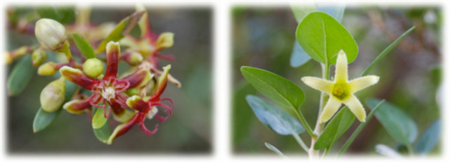
Cabe destacar también la presencia de comunidades vegetales muy peculiares, como es el caso del «cornical», o el «oroval», que en toda la Comunidad Valenciana sólo aparecen en estas sierras. Plantas que presentan curiosas adaptaciones a las condiciones de aridez locales como por ejemplo defoliar en verano en vez de en otoño. Todo ello sin menospreciar la aparición de otros cientos de especies de mayor distribución geográfica, muchas de las cuales poseen gran valor estético, aromático y medicinal.
La riqueza botánica de la sierra motivó a la administración comunitaria a declarar dos microrreservas de flora con el objeto de garantizar la conservación de estas especies y sus hábitats.
Dependiendo de la altura, orientación de las laderas, tipo de sustrato ó condiciones de insolación existen diferentes tipos de comunidades vegetales con diferentes especies que las representan, así en las zonas más altas, podemos encontrar los pastizales, espartales ó tomillares y en las zonas más bajas donde se acumula algo de suelo aparecen bosquetes de coníferas y matorral alicantino como los cornicales, espinares, genistares etc..
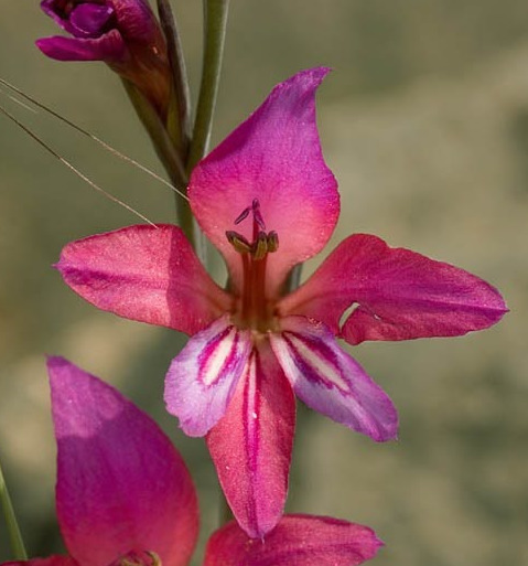
En los barrancos más umbrosos se pueden encontrar especies de helechos como algunos de los géneros Cheilantes, Asplenium ó Ceterach y en determinadas estaciones podemos disfrutar de la efímera presencia de algunas anuales tan espectaculares como las orquídeas.
LA RUTA
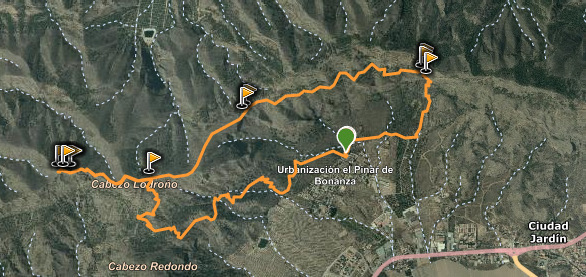
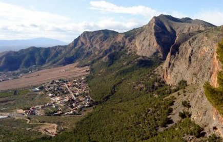
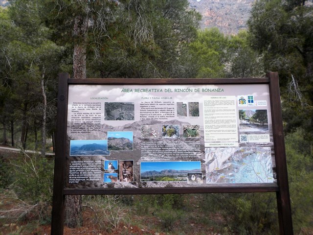
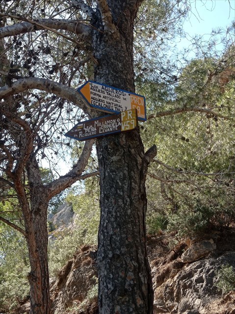
El principio de la senda de subida al punto geodésico se encuentra en la Urbanización Pinar de Bonanza, justo donde comienza el acceso peatonal al AREA RECREATIVA RINCÓN DE BONANZA. Y está marcada por una señal. Se empieza por un camino de hormigón que pronto pasa a ser detierra, junto a unos limoneros. Luego se llega a una senda en buenas condiciones y fácil de seguir, ya que es muy utilizada por la gente de Orihuela y sus pedanías.
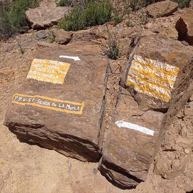
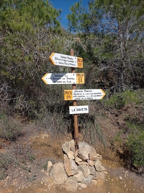
Salvo en un tramo en el que la elevada inclinación de la ladera se salva con el zigzag de la senda, el resto va subiendo de una forma moderada y prácticamente constante. El sendero está bastante transitado y no ofrece dudas. Serpentea por la cara ESTE de la sierra, entre pinos, para subir a un collado, donde encontramos un poste señalizador que nos indica que estamos en el punto II de la Senda de la Muela. Desde este punto podemos subir hacia el punto geodésico y la Cruz de la Muela o bien descender hacia Boca del Puerto y La Almazara.
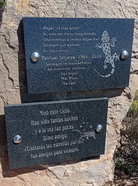
Ahora la ruta continúa por una senda que discurre cerca de la cima de la sierra, pero por la cara ESTE, mucho más poblada de pinos pero calurosa hasta la tarde. Se sigue el ascenso serpenteante hasta llegar al llamado CORRALITO, donde podemos tomar un descanso antes de iniciar la subida hacia el punto geodésico. Alli, próximo al caché #09 de la serie se encuentra una placa en recuerdo de Pascual Segarra, uno de los mayores enamorados de esta sierra, pues ese precisamente era su lugar favorito. Allí fueron esparcidas sus cenizas tras fallecer en 2014.
NOS ENCONTRAMOS CON UN CRUCE DE SENDAS IMPORTANTE: La ruta sigue hacia la izquierda, hacia el punto geodésico y los cachés #10, #11 y #12, si bien hay que regresar posteriormente a este punto para tomar la senda a la derecha. , por lo que quien no desee subir al punto geodésico puede continuar desde este punto hacia el caché #13.
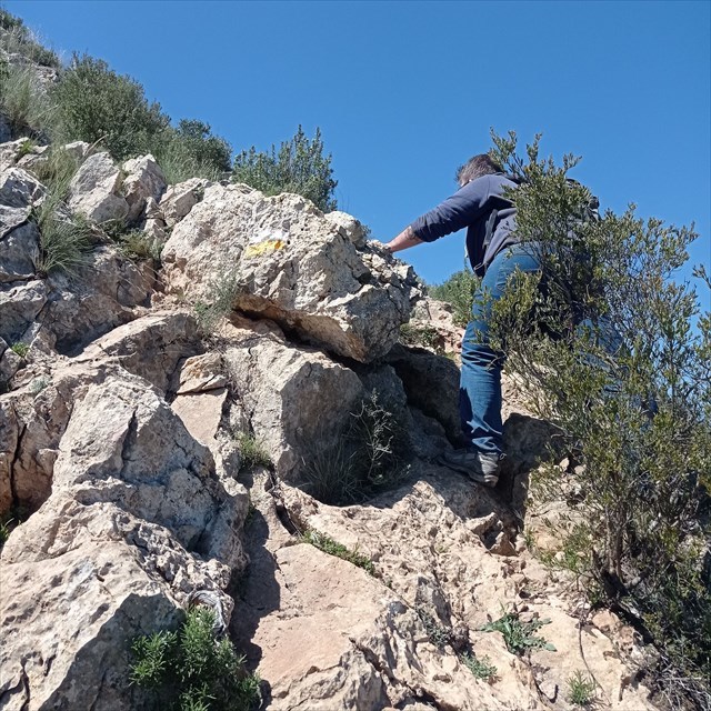
Si continuamos hacia el punto geodésico, la senda discurre de forma bastante moderada y sin dificultad hasta el tramo final, el más exigente de la subida donde habrá que poner las manos para algunas trepadas. MUCHO CUIDADO ESPECIALMENTE PARA LOS NIÑOS O PERSONAS CON ALGUNA LIMITACIÓN DE MOVILIDAD
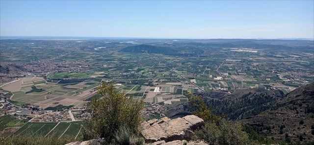
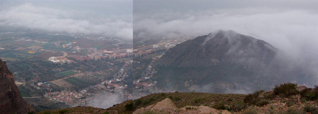
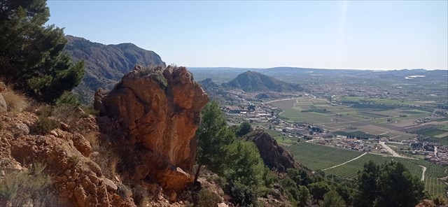
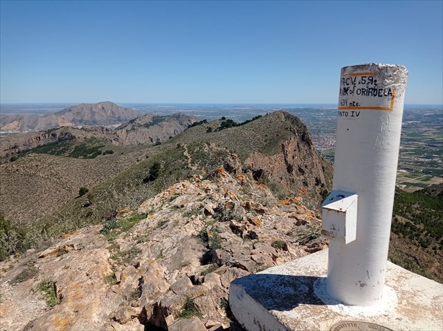
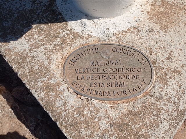
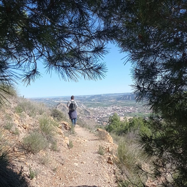
Una vez superados esos tramos, llegamos al PUNTO GEODÉSICO DE LA SIERRA DE ORIHUELA, a 634 metros sobre el nivel del mar, punto mas alto de este recorrido y donde podemos divisar Murcia, toda la Vega Baja y la Sierra de Callosa.
Tras recorrer en sentido inverso la senda hasta llegar nuevamente al Corralito, iniciamos la siguiente parte del recorrido, tomando la senda que conduce hacia el Cabezo Lodroño. La senda es en general descendente y sin grandes dificultades y se recorre de forma rápida y disfrutando de excelentes vistas. Tras pasar el caché #16 llegamos a una confluencia de varios caminos, debiendo tomar el que se indica en DIRECCIÓN A “LOS AGUJEROS”.
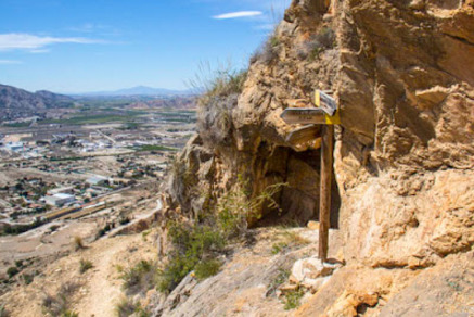
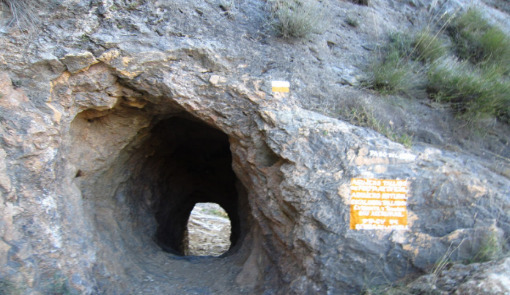
Siguiendo la senda ligeramente descendente llegamos a un PUNTO IMPORTANTE. DEBEMOS TOMAR LA SENDA QUE SE DIRIGE HACIA LOS AGUJEROS Y LOS ESCALONES TALLADOS DEL PASO DEL GATO. Este punto está marcado especialmente en el CACHÉ #18. Es importante no confundirse en este punto pues de seguir la otra senda volveríamos a ascender hacia la Cruz de la Muela.
Llegamos por fin a un punto importante en la ruta: El Paso del Gato, una zona algo más abrupta en la que nos tenemos que ayudar con las manos para descender tras pasar por un par de oquedades en la roca.
IMPORTANTE: EN ESTE PUNTO LA RUTA CONFLUYE CON LA OTRA RUTA DE CACHÉS DE LA SIERRA, SIENDO EL CACHÉ #21 COMUN A AMBAS SERIES.
Tras superar esta fase de descenso pronunciado, la senda gira a la derecha en dirección al punto final, que es el mismo desde el que iniciamos la ruta.
Ficha de la ruta
• Actividad: Ruta de Media Montaña con sendas, veredas y un trepado de baja/media dificultad.
• Sierra: Sierra de Orihuela
• Posición Geológica Regional: Cordilleras Béticas - Zonas Externas - Prebético
• Comarca: Vega Baja del Segura, Alicante
• Distancia: 8.3 km
• Punto de Partida: Parking urbanización Pinar de Bonanza. .
• Punto de Llegada: Parking urbanización Pinar de Bonanza.
• Circular: Si
• Desnivel superado: Inicial 62 m. máximo 634 m.
• Caminos Homologados: Ruta PR CV 59 y sendas
• Itinerario: Urbanización Pinar de Bonanza – Senda PR-CV-59 hasta El Corralito – Subida hasta el punto geodésico y retorno por el mismo camino nuevamente hasta El Corralito - Senda descendente hacia el Paso del gato cruzando Los Agujeros – Senda derecha hacia balsas de riego – vuelta a Urbanización Pinar de Bonanza.
• Calificación Técnica: Media. El ascenso al punto geodésico y el descenso por el Paso del gato requiere y conocimiento y cuidado algo mayor.
• Calificación de exigencia Física: Media
• Recomendaciones: Esta ruta y en general el senderismo de montaña requiere una adecuada preparación física, una buena planificación previa de la ruta en el sentido de conocer a donde se va y por donde, una buena reserva alimentaría y liquida (no confiarse nunca en que nos podamos encontrar fuentes) y desde luego ir provisto del material adecuado (prendas, calzado…). E incluso aspectos tales como la meteorología y el saber seleccionar la ruta según la época del año son importantes tenerlos en cuenta a la hora de acometer una ruta de montaña de manera segura y por ende satisfactoria.
LOS CACHÉS
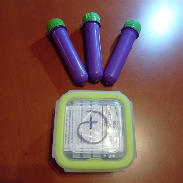
Se trata de UNA SERIE DE 25 cachés, de los cuales 24 son formato preforma cilíndrica con cierre rosca, tamaño pequeño, unos 12 x 4 cm, en cuyo interior encontramos sólo el logbook. Ademas, 1 caché más formato tupper pequeño, de 15 x 8 x 5 cm. que contiene logbook para logs, FOLLETO EXPLICATIVO de en que consiste en geocaching, LAPIZ (Gracias de todo corazón a IKEA), SACAPUNTAS y algún pequeño REGALO. Inicialmente en éste caché se deposita TRAVEL BUG para ser movido a otros cachés. POR FAVOR, UTILIZAR EL MINIMO ESPACIO POSIBLE DE LOS LOGBOOKS PARA LOS LOGS, de esta forma durará más. Es muy importante volver a dejarlo tal como se encontró. En todos los listing hay FOTOS SPOILER correspondientes a cada uno de ellos.
Gracias y FELIZ BUSQUEDA!!

PR-CV-59 II – RUTA CIRCULAR GEODESICO DE ORIHUELA

This series of 25 caches aims to make a circular mountain route along the Sierra de Orihuela, starting and ending in the Pinar de Bonanza Urbanization, visiting the geodesic point of the Sierra de Orihuela and Paso del Gato, where it converges with the other series of caches of this route PR-CV-59 being cache #21 common to both series. To do this, we will follow the PR-CV-59-II Route for most of the route. The path runs along paths and paths delimited and marked with paint. I hope you enjoy absolutely spectacular views.
ATTENTION: This is a route of medium difficulty, physically somewhat demanding and it is preferable to have some experience in the mountains, not requiring special equipment. IT IS NOT SUITABLE for children under 8 years of age or recommended for people with respiratory or cardiovascular problems.
THE SIERRA DE ORIHUELA
The Sierra de Orihuela is a mountainous alignment located between the southern limit of the province of Alicante and the eastern end of Murcia. It belongs to the Bajo Segura region, in particular to the municipal districts of Orihuela and Santomera.
The Maximum Height is 634 m. tall at its peak. Some of its peaks are La Muela, Pico de la Cruz de la Muela (564 m.), Pico del Cuervo, Pico del Águila (634 m.).
Geologically, it is located within the Baetic domain. Together with the Sierra de Callosa, it forms a mountainous alignment made up of Triassic dolomitic limestone blocks, which emerge isolated in the middle of the alluvial plain. Its shapes are abrupt and very fragmented.3 Since ancient times, these mountains have been the object of mining activity, and the wells and galleries that we can still find are frequent. Basically, together with some currently abandoned gypsum and limestone exploitations, iron ore and in a few places native gold were extracted.
The entire mountain range has numerous hollows, shelters and caves of variable development, which gives the rugged landscape a certain uniqueness and geomorphological beauty.
Hydrologically, the entire area is subject to high insolation in the summer months. This factor, together with the low rainfall, makes it difficult for permanent water sources and courses to exist. Only the source of San Cristóbal can contain some water after important rains.
In terms of fauna, birds are the best represented group, highlighting the presence of the Bonelli's eagle (Hieraetus fasciatus) and the golden eagle, seriously endangered species that nest in the area, the eagle owl (Bubo bubo), the long-eared owl (Asio otus), common kestrel (Falco tinnunculus), sparrowhawk (Accipiter nisus) and the peregrine falcon (Falco peregrinus). In the cornial formations they are home to rare birds such as the trumpeter finch (Bucanetes githagineus) and the roller (Coracias garrulus).
Among the mammals, it is worth mentioning the presence of the fox, the wild cat (Felis sylvestris), the mountain goat and the hare.
The flora is one of the most remarkable biological variables of the ecosystem that houses this Sierra, not only because of the large number of species that inhabit it, among which the Ashy Cat's Tail (sideritis glauca) and the Rock Thistle (Centaurea saxicola) stand out. ) that appear abundantly in the Sierras de Callosa and Orihuela.
It is also worth noting the presence of very peculiar plant communities, such as the "cornical" or the "oroval", which only appear in these mountains throughout the Valencian Community. Plants that present curious adaptations to local arid conditions, such as defoliating in summer instead of in autumn. All this without neglecting the appearance of hundreds of other species with a greater geographical distribution, many of which have great aesthetic, aromatic and medicinal value.
The botanical richness of the mountains motivated the community administration to declare two flora micro-reserves in order to guarantee the conservation of these species and their habitats.
Depending on the height, orientation of the slopes, type of substrate or insolation conditions, there are different types of plant communities with different species that represent them, thus in the highest areas, we can find grasslands, espartales or thyme and in the more low where some soil accumulates there are coniferous forests and Alicante scrub such as cornicales, espinares, genistares etc.
En los barrancos más umbrosos se pueden encontrar especies de helechos como algunos de los géneros Cheilantes, Asplenium ó Ceterach y en determinadas estaciones podemos disfrutar de la efímera presencia de algunas anuales tan espectaculares como las orquídeas.
THE PATH
The beginning of the path to the geodesic point is located in the Pinar de Bonanza Urbanization, just where the pedestrian access to the RINCÓN DE BONANZA RECREATIONAL AREA begins. And it is marked by a sign. It begins with a concrete path that soon becomes dirt, next to some lemon trees. Then you come to a path in good condition and easy to follow, since it is widely used by the people of Orihuela and its districts.
Except for a section in which the steep slope of the slope is saved by the zigzag of the path, the rest goes up in a moderate and practically constant way. The trail is well traveled and offers no hesitation. It winds along the EAST face of the mountain range, between pines, to climb a hill, where we find a signpost that tells us that we are at point II of the Senda de la Muela. From this point we can go up to the geodesic point and the Cruz de la Muela or descend towards Boca del Puerto and La Almazara.
Now the route continues along a path that runs near the top of the mountain range, but on the EAST face, much more populated by pine trees but hot until the afternoon. We follow the winding ascent until we reach the so-called CORRALITO, where we can take a break before starting the climb towards the geodesic point. There, next to cache #09 of the series, there is a plaque in memory of Pascual Segarra, one of the greatest lovers of this mountain range, because that was precisely his favorite place. His ashes were scattered there after he died in 2014.
WE FIND AN IMPORTANT CROSSROADS: The route continues to the left, towards the geodesic point and caches #10, #11 and #12, although it is necessary to return to this point later to take the path to the right. , so whoever does not want to go up to the geodesic point can continue from this point to cache #13.
If we continue towards the geodesic point, the path runs quite moderately and without difficulty until the final section, the most demanding of the ascent where we will have to put our hands to some climbs. GREAT CARE ESPECIALLY FOR CHILDREN OR PEOPLE WITH SOME MOBILITY LIMITATIONS
Once these sections have been overcome, we arrive at the GEODETIC POINT OF THE SIERRA DE ORIHUELA, at 634 meters above sea level, the highest point of this route and where we can see Murcia, the entire Vega Baja and the Sierra de Callosa.
After traveling the path in the opposite direction until we reach the Corralito again, we begin the next part of the route, taking the path that leads to Cabezo Lodroño. The path is generally descending and without great difficulties and is covered quickly and enjoying excellent views. After passing cache #16 we arrive at a confluence of several paths, having to take the one indicated in DIRECTION TO “LOS AGUJEROS”.
Following the slightly descending path we reach an IMPORTANT POINT. WE MUST TAKE THE PATH THAT LEADS TOWARDS THE HOLES AND CARVED STEPS OF PASO DEL GATO. This point is especially marked in CACHE #18. It is important not to get confused at this point because if we followed the other path we would ascend again towards Cruz de la Muela.
We finally reach an important point on the route: El Paso del Gato, a somewhat steeper area where we have to help ourselves with our hands to descend after passing through a couple of holes in the rock.
IMPORTANT: AT THIS POINT THE ROUTE CONFLUDES WITH THE OTHER CACHES ROUTE OF THE SIERRA, CACHE #21 BEING COMMON TO BOTH SERIES.
After overcoming this phase of steep descent, the path turns to the right towards the end point, which is the same from which we started the route.
Route tab
• Activity: Medium Mountain Route with paths, paths and a climb of low/medium difficulty.
• Sierra: Sierra de Orihuela
• Regional Geological Position: Betic Cordilleras - External Zones - Prebético
• Region: Vega Baja del Segura, Alicante
• Distance: 8.3 km
• Starting point: Parking urbanization Pinar de Bonanza. .
• Arrival Point: Parking urbanization Pinar de Bonanza.
• Circular: Yes
• Unevenness overcome: Initial 62 m. maximum 634 m.
• Approved Roads: Route PR CV 59 and paths
• Itinerary: Pinar de Bonanza urbanization – PR-CV-59 path to El Corralito – Ascent to the geodesic point and return along the same path again to El Corralito – Descending path towards Paso del gato crossing Los Agujeros – Right path towards rafts of irrigation – return to Pinar de Bonanza Urbanization.
• Technical Qualification:Medium. The ascent to the geodesic point and the descent through the Paso del gato requires a little more knowledge and care.
• Physical requirement rating: Medium
• Recommendations: This route and mountain hiking in general requires adequate physical preparation, good prior planning of the route in the sense of knowing where you are going and where, a good food and liquid reserve (never trust that we can find sources) and of course be provided with the appropriate material (clothes, footwear...). And even aspects such as the weather and knowing how to select the route according to the time of year are important to take into account when undertaking a mountain route safely and therefore satisfactorily.
THE CACHES
It is a SERIES OF 25 caches, of which 24 are cylindrical preform format with screw closure, small size, about 12 x 4 cm, inside which we find only the logbook. In addition, 1 cache plus small tupperware, 15 x 8 x 5 cm. containing logbook for logs, EXPLANATORY BROCHURE of what geocaching consists of, PENCIL (Thanks to IKEA with all my heart), PENCIL SHARPENER and some small GIFT. Initially TRAVEL BUG is deposited in this cache to be moved to other caches. PLEASE, USE THE MINIMUM POSSIBLE SPACE OF THE LOGBOOKS FOR THE LOGS, this way they will last longer. It is very important to return it to the way it was found. In all the listings there are SPOILER PHOTOS corresponding to each one of them.
Thank you and HAPPY SEARCHING!!