This is an Earthcache – as such, there is no physical cache. Instead you will partake in a geology lesson by making observations and answering 4 questions about the Devil's Racecourse at the posted coordinates.

Devil’s Racecourse is a barren half-mile long river of boulders in Washington County. It is sometimes described as an “upside-down river” because the Little Antietam Creek flows beneath the rocks. You can feel and hear the water flowing while walking on the formation, and if you look down just the right hole you can see it.
The upper layer of rocks that form the Devil’s Racecourse broke away millions of years ago during the last Ice Age when glaciers covered part of today’s United States. A majority of the rocks that make up this large river of boulders is weverton quartzite.
The word “Quartzite" usually refers to rocks metamorphized and composed almost entirely of quartz. These rocks started journey out as just plain old sand, probably laying around on some ancient beach somewhere. Through the magic of the Rock Cycle it was compacted into pure quartz sandstone, then it was converted through the process of heat & pressure and changed into these metamorphic rocks.

Now this rock field was not the result of the glaciers themselves, as the closest a glacier to this point was over 70 miles north. Instead, it was created by tundra conditions by the glaciers furthest southern advance. The climate during this time would alternately freeze and thaw, and this created a slow movement of land called “solifluction."
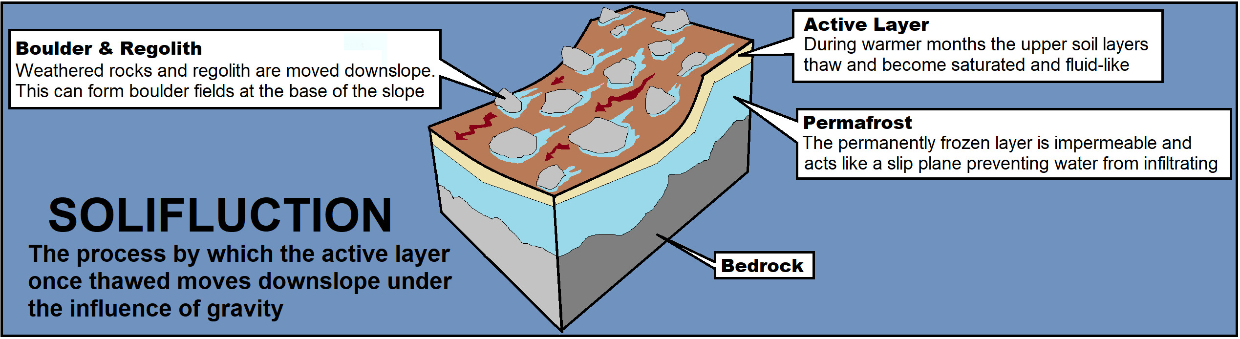
Solifluction is defined as gradual movement of wet soil or other material down a slope, especially where frozen subsoil acts as a barrier to the percolation of water.

Basically, in warmer periods water seeped into rocks, than as it got colder, that water froze, expanded, and broke the boulders apart. The process of solifluction involves a downhill movement in an area of permafrost, where the ground remains frozen all year round. As the climate became warmer, the boulders discontinued their movement and became stationary.
The end result here was this jagged half mile of rocks that probably got it's name by looking like the Devil’s attempt to create an impossible race course (Although I also read it may have gotten it's name from superstitious folks thinking that the sounds of water flowing below the boulder field sounded like “devils” whispering to each other).
LOGGING REQUIREMENTS:
To log this Earthcache: Read the geology lesson above. Answer all four questions posted below and send them via e-mail or messenger contacts on my Geocaching profile.
QUESTION 1. What is the gradual movement of wet soil or other material down a slope called?
QUESTION 2. Before it was compacted and changed, what form did this quartzite start its journey as?
QUESTION 3. Do the rocks feel settled in or do they move easily?
QUESTION 4. Did you feel or hear the water flowing beneath you?
OPTIONAL PHOTO: Posting a photo that readily indicates that you (and anyone else logging the find) are at the location.

 Awesnap has earned GSA's highest level:

REFERENCES:
1. Geology, Catoctin Mountain, National Park Service, nps.gov
2. Catoctin Formation - Metabasalt, , mrdata.usgs.gov
3. Weathering and Erosion - Devil's Racecourse, website, education.fcps.org
4. The 'Devil's Racecourse': local relic of the last Ice Age, Umbaugh, Nellie, The Daily Mail, February 9, 1976, newspapers.com
5. A Deep Dive Into the Properties of Quartzite, Marin Kirk, Use Natural Stone, August 24, 2018, usenaturalstone.org
6. Metamorphic Rocks, Columbia University, columbia.edu