English description after Finnish - scroll down.
Jurmo - III Salpausselän ääripiste
Jurmo on ainutlaatuinen jääkauden, meren ja tuulen muovaama saari. Se sijaitsee ulkosaaristossa saaristomeren etelälaidalla. Tämä geokätkö tutustuttaa sinut saaren ainutlaatuiseen geologiaan ja upeisiin luonnonkauniisiin paikkoihin.
Tämä kätkö on tyyppiä earthcache eli maakätkö. Jotta voit logata kätkön, sinun pitää vastata esitettyihin geologiaan liittyviin kysymyksiin.
Jurmon saarelle voi saapua yhteysaluksella tai omalla veneellä. Katso yhteysaluksen aikataulut ja ohjeet täältä: Meritie.fi
Voit myös tutustua saareen ja sen palveluihin täältä: Jurmo.com
Osa saaresta kuuluu saaristomeren kansallispuistoon. Lue lisää täältä: luontoon.fi
Huomaa, että lintujen pesimäaikana 1.4.-31.7. saaren lounaisosassa ei saa liikkua ollenkaan. Kieltotaulut osoittavat alueen rajan.
Itämeren kehitysvaiheet
Viimeisen jääkauden eli Veiksel-jääkauden lopulla ilmasto alkoi lämmetä noin 18000 vuotta sitten. Mannerjäätikön sulaessa ja sen reunan vetäytyessä Keski-Euroopasta kohti pohjoista ja luodetta, Itämeren paikalle syntyi makeavetinen Baltian jääjärvi, josta ei ollut suoraa yhteyttä valtameriin. Järven eteläpää rajoittui rantaan, joka kulki yhtenäisenä nykyisestä Etelä-Ruotsista Tanskan ja Saksan kautta Puolaan ja Baltiaan. Idässä Laatokka oli osa Baltian jääjärveä. Järven pohjoisosaa reunusti yhtenäinen jäätikkö. Noin 13000 vuotta sitten jäätikön eteläreuna kulki Keski-Ruotsista Pohjois-Itämeren ja Suomenlahden rannikon kautta Karjalaan. Suomi oli siis käytännössä kokonaan 2-3 km paksun mannerjään peittämä.
Noin 11600 vuotta sitten mannerjää suli Skandinaviassa niin, että sen reuna vetäytyi pohjoiseen Billingeninvuoren pohjoispuolelle. Tämä avasi Baltian jääjärvelle suoran yhteyden Keski-Ruotsin läpi Pohjanmereen karkeasti linjalle Tukholman eteläpuolelta Oslon eteläpuolelle. Sen seurauksena veden pinta laski noin 25 metriä valtameren tasolle lyhyessä ajassa. Baltian jääjärvestä oli näin tullut Yoldiameri. Sen vesi oli sekoitus suolaista valtameren vettä ja jäätiköiltä sulavaa makeaa vettä.
Jäätikön jatkaessa pienentymistään, maan pinta kohosi jään painon väistyttyä. Noin 10800 vuotta sitten Keski-Ruotsin maanpinta oli kohonnut niin paljon, että yhteys valtamereen meni umpeen. Yoldiameri muuttui jälleen makeavetiseksi altaaksi. Tätä vaihetta kutsutaan nimellä Ancylusjärvi. Mannerjää peitti enää osaa Pohjois-Ruotsia, -Norjaa ja Länsi-Lappia. Ancylusjärvi peitti alleen koko nykyisen Itämeren alueen. Etelässä sen pinta-ala oli hiukan nykyisen Itämeren alaa pienempi, mutta Pohjois-Itämeren, Pohjanlahden ja Suomenlahden alueella rantaviiva oli huomattavasti enemmän sisämaassa kuin nyt maankuoren ollessa painuneena. Laatokka oli edelleen osa samaa järveä.
Ilmaston lämpeneminen johti noin 8000 vuotta sitten napajäätiköiden sulamiseen ja valtamerten pinnan nousuun. Kun vesi nousi Atlantissa, se tunkeutui Tanskan salmien kautta Ancylusjärveen ja teki siitä jälleen meren. Tätä vaihetta 8000-3000 vuotta sitten kutsutaan Litorina-mereksi. Vesi oli nykyistä suolaisempaa ja meri peitti edelleen meren pohjoisosissa nykyistä laajemman alueen. Maan kohoamisen myötä Laatokka kuitenkin erkaantui omaksi järvekseen. Noin 3000 vuotta sitten maankohoaminen oli jatkunut niin paljon, että veden virtaus valtameren ja Itämeren välillä väheni ja syntyi nykyinen murtovetinen Itämeri.
Salpausselkien synty
Mannerjäätikkö oli jatkuvassa liikkeessä. Lunta kinostui sateena ja jäätä syntyi jäätikön päälle koko ajan lisää ja jää virtasi eli työntyi kohti jäätikön reunoja. Samalla se kuitenkin suli reuna-alueilta ja meren kohdalla jään painuessa veteen sen reunasta lohkeili jäävuoria. Kun jään virtaus ja sulaminen olivat tasapainossa, jäätikön laajuus pysyi ennallaan. Noin 13000 vuotta sitten ilmasto oli vähitellen lämpiämässä. Mannerjäätikkö alkoi vetäytyä. Tätä kutsutaan deglasiaatioksi. Jäätikkö alkoi siis pienentyä eli se suli reunoista ja oheni paksuutta enemmän kuin mitä virtaus työnsi jäätä kohti reunoja. Sulamisessa oli nopeampia vaiheita, jolloin jäätikkö vetäytyi kohti luodetta, sekä hitaampia vaiheita, jolloin jäätikön reuna pysyi lähes paikoillaan liikkuen vain muutaman sadan metrin matkalla vuosikaudet.
Mannerjäätikön perääntymisen eli deglasiaation aikataulu
| n. 13000 |
Uudenmaan rannikko |
|
13000-12250
|
Heinolan deglasiaatio + Salpausselkä-eteneminen |
| 12250-12050 |
I Salpausselkä |
| 11790-11590 |
II Salpausselkä |
| 11590 |
Baltian jääjärven lasku |
| 11400-11300 |
III Salpausselkä ja Pielisjärven reunamuodostuma |
| 11350-11000 |
Keuruun deglasiaatio + Jyväskylän eteneminen |
| 11000-10900 |
Sisä-Suomen reunamuodostuma |
| 10200 |
Perämeren rannikko |
Ensimmäisen deglasiaatiovaiheen, ns. Heinolan deglasiaation aikana jäätikön reuna vetäytyi noin 50 km ensimmäisen Salpausselän pohjoispuolelle, josta se kuitenkin ilmaston kylmenemisen takia laajeni takaisn I Salpausselän kohdalle. Siinä jään reuna pysytteli noin 200 vuotta ja syntyi satojen kilometrien pituinen reunamuodostuma. Sama toistui noin 200 vuoden jään vetäytymisvaiheen jälkeen noin 20 km pohjoisempana, jolloin syntyi II Salpausselkä. Baltian jääjärven pinnan laskettua jäätikön vetäytyminen pysähtyi uudelleen ja synnytti III Salpausselän läntiseen osaan maata.
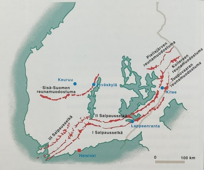
Kuvan ja taulukon lähde: Jääkaudet, WS Bookwell Oy 2004
III Salpausselkä ja sen jatke saaristomerellä
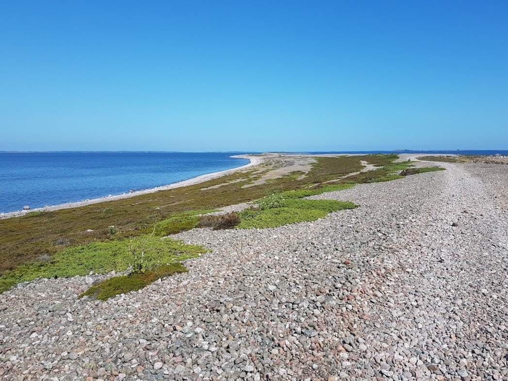
Kolmas Salpausselkä syntyi noin 11400-11300 vuotta sitten. Tätä ennen makeavetisen Baltian jääjärven pinta oli laskenut lyhyessä ajassa noin 25 metriä. Samalla sitä vanhemmat I ja II Salpausselän yläosat olivat tulleet meren pinnalle. Veden laskettua ja jäätikön sulamisen jälleen hidastuttua kolmas Salpausselkä muodostui jäätikön Itämeren kielekkeen laidalle, joka kulki nykyisen Päijänteen länsipuolelta Padasjoelta, Rengon, Someron, Kiikalan ja Muurlan kautta Kemiönsaaren läpi kohti lounasta. Kolmas Salpausselkä ei ole yhtä yhtenäinen kuin I ja II Salpausselkä. Mantereella sen muodostaa jaksoittaiset reunamuodostumat ja -tasanteet, Saaristomerellä on nähtävissä sen jatke, joka koostuu lähinnä yksittäisistä harjusaarista sekä sora- kivikkosärkistä linjalla, joka kulkee Dragsfjärdistä Sandskärin ja Sandön saaren kautta melko suoraan kohti lounasta päättyen Jurmon harjusaareen ja Utön hiekka- ja sorakerrostumiin. Koska III Salpausselkä synty meren pinnan alle, osa siitä peittyi ajan kuluessa kertyneiden hienojakoisten savikerrostumien alle. Sen tarkkaa korkeutta onkin vaikea määritellä. Merialueella III Salpausselän jatkeen muodostamien harjusaarten korkeimmat kohdat ovat 10-15 metriä nykyisen vedenpinnan yläpuolella.
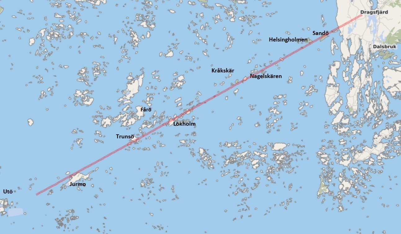
© OpenStreetMap tekijät
III Salpausselän syntyaikaan Itämeren (siihen aikaan Yoldiameri-vaiheessa) pinta oli useita kymmeniä metrejä korkeammalla kuin tänä päivänä. Tai oikeammin maan kuori oli alempana mannerjään painettua sitä syvemmälle jääkauden aikana. III Salpausselkä syntyi jäätikön reunaan meriveden pinnan alle kertyneistä maa-aineksista.
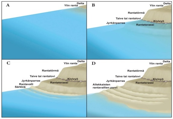
Reunamuodostuman rakenne
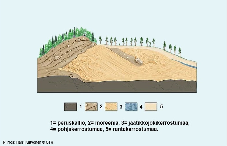
Jäätikkö kuljetti maa-aineksia eri tavoin. Jään työntämä lajittumaton moreeni kertyi jään reunan alle peruskallion päälle ja aivan pinnalle mannerjään puoleiseen reunaan. Sulamisvirtojen kuljettamat sora-, hiekka- ja hietakerrokset kerrostuivat lajittuen reunamuodostuman distaalipuolelle eli harjanteen taakse jäätiköstä pois päin. Reunamuodostuman distaalipuolesta tuli loivempi kuin jään puoleisesta reunasta, jota jäätikkö liikutteli eri vuosina ja vuodenaikoina laajentuessaan ja vetäytyessään vuorotellen. Kauemmaksi jäätikön reunasta, missä vesi ei enää virrannut, kertyivät hienojakoisimmat maalajit hiesu ja savi. Kallioisen saariston merenpohjalle ovatkin monin paikoin tyypillisiä savitasangot kalliokohoumien välissä.

Merivesi on kuluttanut Salpausselän kerrostumia sen syntymisen jälkeen. Isompia harjusaaria lukuun ottamatta hienojakoisempia aineksia on Saaristomerellä tyypillisesti jäljellä kallioiden kupeessa ja muiden saarten suojaamilla paikoilla, missä virtausten ja aallokon kulutus on ollut vähäisempää Meren voimille alttiimmissa paikoissa näkyy enimmäkseen pienistä kivistä tai isommista pyöristyneistä lohkareista muodostuneita kivikkoja. Maan pinnan kohotessa eri kohdat reunamuodostumasta olivat alttiina meren kulutukselle eri aikoina. Aallokot, tyrskyt ja jäät kuluttivat alkuun tasaiseen rinteeseen jyrkempiä törmiä ja portaita.
© GTK, Harri Kutvonen
Maankohoamisen myötä Jurmon saari nousi meren pintaan suunnilleen samoihin aikoihin kun Litorinameri-vaihe oli päättymässä ja nykyinen murtovetinen Itämerivaihe oli alkamassa noin 3000-4000 vuotta sitten. Maankohoaminen jatkuu tällä alueella noin 4 mm vuodessa. Tänä päivänä nähtävä Jurmon harjusaari on ainutlaatuinen jääkauden tuotos, joka on ollut yli 11000 vuotta meriveden virtausten, aallokon ja jäiden ja myöhemmin myös tuulen vaikutukselle alttiina.
Kätkön loggaamiseksi sinun pitää suorittaa seuraavat tehtävät.
- Mene reittipisteelle 1 (kätkön boguspiste). Kuvaile millaista maa-ainesta on tällä paikalla? Pohdi miten tämä aines on vaikuttanut Jurmon saaren harjumuodostelman syntyyn ja muokkautumiseen..
- Mene reittipisteelle 2. Kuvaile millaista maa-ainesta on tällä paikalla (tyyppi, raekoko)? Mitä merkkejä näet pisteen välittömässä läheisyydessä siitä, miten maa-aineksen kertyminen jatkaa muuttumistaan? Mikä edistää tai hidastaa muutosta?
- Mene reittipisteelle 3. Kuvaile millaista maa-ainesta on tällä paikalla (tyyppi, raekoko)? Paikan pohjois- ja eteläpuolisen alueen maa-aines poikkeaa toisistaan. Pohdi miten reunamuodostelman rakenne näkyy näiden kahden eri puolen maa-ainesten erilaisuudessa. .
- Mene reittipisteelle 4. Kuvaile millaista maa-ainesta on tällä paikalla (tyyppi, raekoko)? Pohdi miksi tätä maalajia on juuri tässä paikassa ja miksi se on pysynyt siinä.
- Mene reittipisteelle 5. Kuvaile millaista maa-ainesta on tällä paikalla (tyyppi, raekoko)? Kuvaile miten aines on kertynyt pohjoispuolisen merenrannan ja korkeimman kohdan välissä. Pohdi mikä on voinut aiheuttaa tämän.
- Mene reittipisteelle 6. Ota valokuva tässä paikassa. Ota kuva kohti itää siten, että saaren itäkärki näkyy kuvassa. Valokuvassa tulee myös näkyä sinun itsesi tai kätköilynimimerkkisi.
Lähetä tehtävien 1-5 vastaukset sähköpostilla osoitteeseen lavaretus.geo@gmail.com. Jos olet kätköilemässä yhdessä kaverin/kavereiden kanssa, voitte lähettää yhteisen viestin, kunhan kaikkien nimimerkit on mainittu viestissä.
Tämän jälkeen voit logata kätkön löydetyksi. Liitä loggaukseen tehtävässä 6 annetun ohjeen mukainen valokuva.
Sinun ei tarvitse odottaa vastausta sähköpostiin ennen kuin voit logata kätkön. Ohjeiden vastainen loggaus ja selkeästi väärät tai puutteelliset vastaukset aiheuttavat kuitenkin loggauksen poistamisen.
Lähteet:
- Jääkaudet, WS Bookwell Oy 2004 (© Koivisto, Hotakainen, Mattila, Kutvonen, GTK, WSOY)
- Suomen viimeisin jääkausi, maantiedon opetusmateriaali 2016 (Järviluoma Leena-Maija)
- Ensimmäinen Salpausselkä, opetusmateriaali (Saimaa geopark, Geologian tutkimuskeskus)
- Kolmas Salpausselkä, Wikipedia: https://fi.wikipedia.org/wiki/Kolmas_Salpausselk%C3%A4
- Itämeren muinaisrannat Suomessa, kandidaatin tutkielma 2018 (Oulun yliopisto, Juho Joenpolvi)
- OpenStreetmapTekijät
- Soil texture, Plant and Soil Sciences eLibrary
------------------------------------------------------------------------------------------------------------------------------
English
Jurmo - the extreme point of the III Salpausselkä terminal moraine

Jurmo is a unique island, formed by ice age, sea and wind. It is located at the southern outskirts of Turku archipelago. This geocache let’s you to get introduced to the island’s unique geology and fabulous natural beauty. This cache is an earth cache. In order to log it, you need to visit the place and answer questions regarding geology of the island.
You can travel to Jurmo with a ferry or by your own boat. See the time-table of the ferry and travelling instructions here: Meritie.fi (in Finnish or Swedish).
You can also get more information on the island and its services here: Jurmo.com (in June 2022 unfortunately only in Finnish)
Part of the island belongs to the Natural park of Turku archipelago. You can read more about it here: luontoon.fi
Note, that during the bird nesting period 1.4.-31.7. it is completely forbidden to go to the south-western part of the island. Signs will show the restricted area on the island.
Evolution phases of the Baltic Sea
During the last ice age, i.e. Veiksel, climate started to warm-up around 18000 years ago. When the continental ice started to withdraw from Middle-Europe towards north and north-west, a freshwater lake, Baltic Ice Lake, was created in the basin of the current Baltic Sea. There was no direct connection from the lake to the ocean. Its southern part was bordered by shores, which routed from current southern Sweden via Denmark, Germany and Poland to the Baltics. In the east Lake Ladoga was part of the Baltic Ice Lake. The northern side of the lake was limited by continental ice. About 13000 years ago the edge of the glacier went from Middle-Sweden via northern Baltic Proper and Gulf of Finland to Karelia. Finland was fully covered by 2-3 km thick continental ice.
Appr. 11600 years ago the glacier continued melting in Scandinavia and withdrew to the northern side of Mount Billingen. This opened up a direct connection from the Baltic Ice Lake to the North Sea through Middle-Sweden, roughly from southern side of Stockholm to south of Oslo. As a consequence water level declined by about 25 m in a short time. Baltic Ice Lake had transformed to Yoldia Sea. It gradually changed to brackish water - a mixture of salty ocean water and freshwater melting from the glacier.
When the continental ice continued shrinking, earth’s crust started to rebound, when the weight of the glacier had disappeared. Appr. 10800 years ago earth’s crust had been risen so much that the connection to the ocean was closed up. Yoldia Sea transformed again to a freshwater lake. This stage is called Ancylys Lake. Continential ice was covering only part of the northern Sweden, Norway and western Lapland in the north of Finland. Ancylus Lake covered in the south somewhat smaller area than the current Baltic Sea, but on the northern half shoreline of the Baltic Proper, Gulf of Bothnia, and Gulf of Finland was significantly more inland than now, as earth’s crust was depressed. Lake Ladoga was still part of the same lake.
Climate warming led to melting of polar glaciers about 8000 years ago. This resulted in a rise of water level in oceans. When water level was rising in Atlantic, it penetrated through the Danish straits to Ancylus Lake and made it again brackish water sea. This phase appr. 8000-3000 years ago is called Littorina Sea. Water was saltier and the area was still larger than today in the northern part of the sea. Rising of earth’s crust had, however, separated Lake Ladoga from the sea. About 3000 years ago land uplift had continued so much, that the flow between the Littorina sea and the Atlantic was reduced. From this time on the current low-salt brackish water Baltic Sea phase is considered to begin.
Creation of Salpausselkä terminal moraines
Continental ice was constantly moving. Snowfall increased volume on top of the glacier and the ice was flowing, i.e. pushed out towards the edges. At the same time it melted from the outline. By the seaside icebergs were split off when ice was bent down into water. When the flow and melting were balanced, the area of the glacier remained unchanged. About 13000 years ago climate was gradually warming up. Continential ice was withdrawing. This is called deglaciation. The glacier was shrinking when it melted and got thinner from the sides, more than the flow pushed out new ice from inside-out. Melting had faster stages, when ice was withdrawing towards north-west and slower stages, when the edge of glacier remained almost stable and only moved within a few hundred meters for many years.
Time-table of withdrawal of the continential ice, i.e. deglaciation
| appr. 13000 |
South coast of Finland |
| 13000-12250 |
Heinola deglaciation + Salpausselkä progression |
| 12250-12050 |
I Salpausselkä terminal moraine |
| 11790-11590 |
II Salpausselkä terminal moraine |
| 11590 |
Decline of Baltic Ice Lake |
| 11400-11300 |
III Salpausselkä and Pielisjärvi terminal moraines |
| 11350-11000 |
Keuruu deglaciation + Jyväskylä progression |
| 11000-10900 |
Terminal moraine of inner Finland |
| 10200 |
Coastline of Bothnian Bay |
During the first deglaciation phase, called Heinola deglaciation, the edge of the ice withdrew about 50 km north of the first Salpausselkä line. From there it, however, progressed back to the current I Salpausselkä line due to cooling of climate. There the edge of the glacier stayed for 200 years. During this time a terminal moraine of hundreds of kilometers long was created. Same was repeated after 200 years deglaciation phase about 20 km to the north from the first one creating the II Salpausselkä terminal moraine. After the decline of the Baltic Ice Lake deglaciation was stopped again, which created the III Salpausselkä to the western part of Finland.

Source of the table and the image: Jääkaudet, WS Bookwell Oy 2004
III Salpausselkä and its extension in the Archipelago Sea
The third Salpausselkä was created appr. 11400-11300 years ago. Before this the water level of Baltic Ice Lake had declined in a short time by 25 meters. This brought the upper parts of older I and II Salpauselkä terminal moraines above sea level. When the water level had declined and the withdrawal of ice again slowed down, a third Salpausselkä was created by the side of the Baltic Sea lobe of the glacier, which passed from Padasjoki on the western side of Lake Päijänne via Renko, Somero, Kiikala and Muurla through the Kimito island towards south-west. The third Salpausselkä is not as continuous as the I and II Salpausselkä. On the continental part it consists of intermittent ridges and plateaus. In the Archipelago Sea one can find its extension, which contains mainly isolated ridge islands, gravel and rock banks on a line, which goes from Dragsfjärd via island of Sandö rather straight towards south-west ending to Jurmo terminal moraine island and Utö island’s sand and gravel layers. Because the III Salpausselkä was created below sea level, part of it was covered by finer granular clay layers over time. Its exact height is therefore difficult to define. In the area of Archipelago Sea the highest points of the ridge islands of the III Salpausselkä extension rise 10-15 meters above current sea level.

© OpenStreetMap contributors
When the III Salpausselkä was created (during the Yoldia Sea phase of Baltic Sea) sea water level was several tens of meters higher than today. Or, to be more precise, earth’s crust was lower than today, when continental ice had depressed it during the ice age. The III Salpausselkä was formed from mineral soil material accumulated below sea water by the side of the ice.
Structure of terminal moraine
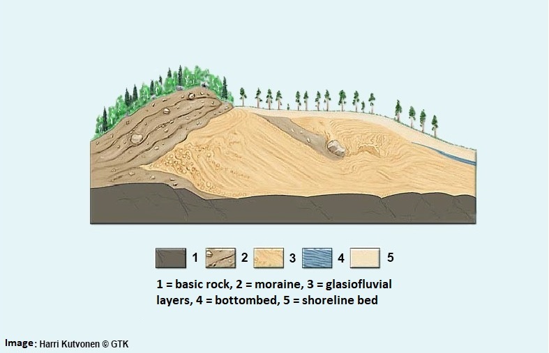
The glacier transported soil in different ways. As ice was pushing towards the edge of glacier, it pushed unsorted moraine on the bottom, just above the basic rock, as well as, on top of the accumulated soil layers on the side of the glacier. Gravel, sand and loam layers transported by water melting from the glacier were sorted and accumulated on the distal side of the terminal moraine, i.e. behind the top of the ridge on the other side than the glacier. The slope of the distal side of the ridge became more gentle than the side of the ice, which was moved by the glacier in different years and seasons, when it progressed and withdrew in turns. Further away from the glacier edge, where water did not flow anymore, silt and clay layers were settled. Clay plateaus between bedrock islands rising from the bottom are indeed quite typical in the Archipelago Sea.
Mineral soil types
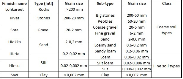
Source: Jääkaudet, WS Bookwell Oy 2004.
Translation and interpretation vs. English soil types based on Plant and Soil Sciences eLibrary.
Sea water has eroded the layers of Salpausselkä moraine after its creation. Except bigger ridge islands one can find finer granular soil material in the Archipelago Sea typically by the side of bedrock slopes and in places protected by other islands, where the influence of sea currents, waves and freezing sea has been less impactful. In other places, which are more exposed to forces of the sea, you can find mostly rock banks consisting of small stones or bigger rounded rocks and blocks. As land is rising different parts of the terminal moraine have been exposed to erosion of the sea at different times. Waves, billows, and ice during winter consumed banks, platforms and steps to the originally smooth slope.

Due to land rising the island of Jurmo got up from the sea approximately during the same period, when the Littorina sea phase was ending and the current Baltic Sea phase was beginning appr. 3000-4000 years ago. Land rising continues in this area by 4 mm/year. Jurmo island, which you can see today, is an extraordinary creation of ice age, and has been over 11000 years exposed to the impact of seawater currents, waves, ice and later also wind.
To log the cache you have to perform following tasks.
- Go to waypoint 1 (bogus point). Describe, what kind of soil is at this place? Reflect, what kind of impact this ground may have had when the terminal moraine of Jurmo island has been created and shaped.
- Go to waypoint 2. Describe what kind of mineral soil you can find at this place (type, grain size)? What signs you can see close by to the waypoint about continuing change of the soil layers? What may accelerate or slow down this change?
- Go to waypoint 3. Describe what kind of mineral soil you can find at this place (type, grain size)? The soil on the northern and southern side of the ridge top differ from each other. Reflect, how the structure of the terminal moraine can be seen in the difference of these two sides.
- Go to waypoint 4. Describe what kind of mineral soil you can find at this place (type, grain size)? Reflect, why just this type of soil is placed here and why it has stayed there?
- Go to waypoint 5. Describe what kind of mineral soil you can find at this place (type, grain size)? Describe, how the soil material has been accumulated between the northern shoreline and the top of the ridge? Reflect, what may have caused this?
- Go to waypoint 6. Take a picture of yourself or your geocache badge with your nick name at this place. Aim at east so that the easternmost end of Jurmo island is visible in the picture.
Send the answers to questions of tasks 1-5 by email to: lavaretus.geo@gmail.com. If you are performing the tasks with friend(s), you can send a joint email, given that the nicknames of everyone are mentioned in the message.
After this you can log the cache found. Attach the picture taken according to the guidelines in task 6 to the log.
You do not need to wait for an answer to your email before logging. However, logs against the guidelines and clearly wrong or incomplete answers will cause removal of the log.
References:
- Jääkaudet, WS Bookwell Oy 2004 (© Koivisto, Hotakainen, Mattila, Kutvonen, GTK, WSOY)
- Suomen viimeisin jääkausi, educational material of geography 2016 (Järviluoma Leena-Maija)
- Ensimmäinen Salpausselkä, educational material (Saimaa geopark, Geologian tutkimuskeskus)
- Kolmas Salpausselkä, Wikipedia: https://fi.wikipedia.org/wiki/Kolmas_Salpausselk%C3%A4
- Itämeren muinaisrannat Suomessa, Bachelor thesis 2018 (Oulu University, Juho Joenpolvi)
- OpenStreetmap Contributors
- Soil texture, Plant and Soil Sciences eLibrary