Note: This Earthcache ONLY should be attempted during conditions of low water flow as the potholes will not visible under high water conditions.
When walking along a dry river or stream bed did you ever wonder why the surface of the bed looks like a piece of Swiss cheese with pot holes marking its surface? This phenominum, called "swirl holes" occurs only under certain geological and hydraulic conditions, ones requiring a consolidated stream bed and periods of strong water flow sufficent to carry pebbles and rocks in which to create sufficent hydraulic forces required to drill into the stream bed. Unfortunately these conditions are not commonly encountered in this area as the surface of much of this area of Texas is covered with recent deposits of loosely consolidated soil rather than hard bed rock conditions required to form the swirl holes.
When approaching any of the waypoints for the 3 of the many locations in which to observe river pot holes, please use extreme CAUTION when close to the creek bank in case errosion has made the 10' high bank unstable.
Your challenge for this earthcache is to: 1) to describe the maximum number of swirl holes (greater than 1" in diameter) that you see within a 5' square of the most dense area of any one of the listed waypoint areas of potholes, 2) describe the shape and estimated depth of the largest holes, describe what you can see trapped in the holes, and finally describe the color and texture of the bedrock of the stream bed.
What is a "Swirl Hole"?
A rock Swirl hole, aka Pothole, is formed when sand, pebbles and small rocks are spun around on bedrock by river currents or wind. As they spin they work like sandpaper and slowly start to grind away the softer rock. The result looks familiar to a pot hole. Once they are started they can vary in size from small to very large depending on the size of the bedrock and the amount of time the river current/wind is strong enough to push the rocks.
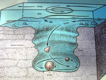
The action of the rocks swirling around in the pothole literally just "drills" down into the bedrock. In the process the stones and pebbles wear away at themselves as well as the bedrock until they are small enough to get out of the hole and they are replaced by other pebbles until the hole fills in or a stone breaks through the downstream side of the pothole.
Swirl Holes in the Mitchell Nature Preserve, Montgomery Co, Texas
