Koro Koro Station was opened near here, right on the motorway, in June of 1875, 14 months after the line was opened to Hutt Station (Lower Hutt). It was a flag station, meaning you had to let the guard (ticket collector) know that you wanted to get off here, or be visible to the driver if you wanted to get on. Traffic on the new line increased and the yards and workshops at Pipitea Point, the terminus at Wellington, soon outgrew their capacity. The Government started looking for space to not only repair the rolling stock but to build them as well. Petone was chosen and in 1876 2.5 hectares were purchased for this on the seaward side of the line. In 1879 Koro Koro Station was moved to the present Petone Station site and named Petoni (with an i). I'll talk more about that in another cache. The original ticket office was removed and used as a police lockup until it burnt down in 1964. Working out where the station was was difficult - there are no photographs, the historical descriptions are a bit vague (near the Koro Koro Stream), the roads have changed and even the shore line here has changed considerably due to reclamation in the 1910s.
In 1885, six years after Koro Koro station was closed, a new private rail line was opened to the Hutt racecourse. The first station on that line was right at the junction and in fact Beach Station was sometimes referred to as Petone Junction, although that name more properly belongs to the track junction itself, and its signalling equipment, rather than the station here. Beach Station was awkwardly located in the curve of the track about where the middle of the roundabout is today. It had no platform but did have a ticket office. It was decommissioned in November in 1897 and replaced with a station further along the beach after complaints about the uneven ground and poor facilities. The ticket office was reused for signalling.
The line to Hutt Park was closed and removed in 1915, apart for the first 900 metres to Petone wharf which was sold to the Gear Meat Company. That section was finally pulled up in the mid 1970s. We'll talk more about this line as we travel along the beach to Hutt Park...
There are the remains of an interesting structure at the waypoint. It looks like it might be an old platform, but the nib is wrong. Boards, maybe? And anyway it is in the wrong location and points in the wrong direction. Maybe a goods loading dock? Even that I doubt. If anyone knows what it was, please sing out.
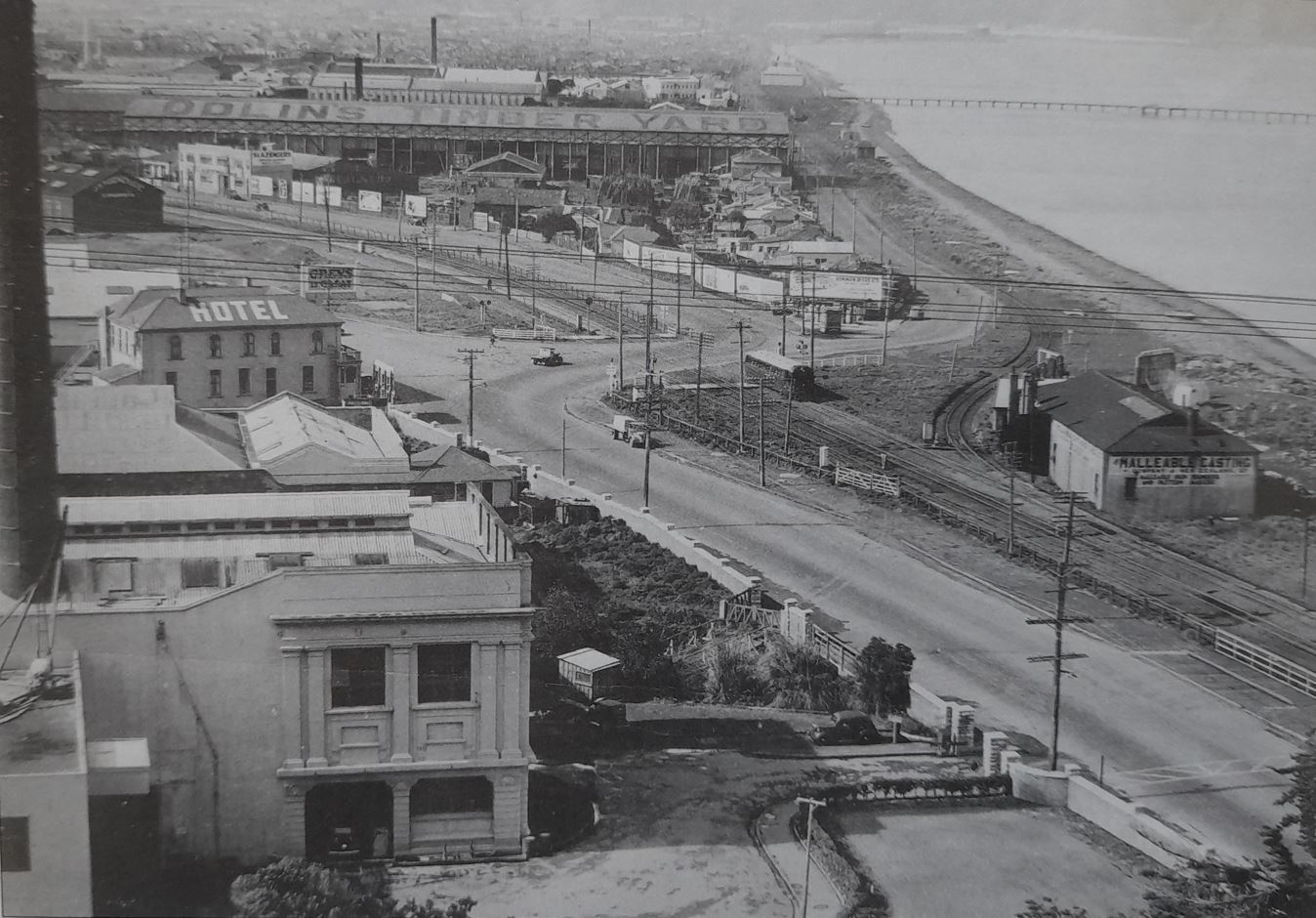
The site of Beach and Koro Koro Stations with a railcar heading south, 1948. Beach Station used to be on the curve of the track heading to the beach. Koro koro station was just left of the road crossing the track. In the photo the rail line along the beach runs only to Odlins Timber and the Gear Meat works behind. Note that reclamation at the mouth of the Korokoro Stream has the beach much further away now. KoroKoro was just left of the intersection.
Korokoro is an abbreviation of Te Korokoro o Te Mana meaning 'the throat of the mana', indicating the importance of the stream as a food supply. Mana is a difficult word to translate, meaning something akin to respect or authority. I am unsure how "the mana" refers to this area.
References:
"Beach Railway Station, Wellington Region", Wikipedia
Scoble, J: "Names and Opening and Closing Dates of Railway Stations", published by the Rail Heritage Trust of New Zealand, 2010.
Parsons, D: "Wellington's Railways Colonial Steam to Matangi", published by the New Zealand Railway & Locomotive Society, 2010