

Bem-vindo à praia ao largo da costa noroeste de África
Bem-vindo à ilha de Cabo Verde da Boa Vista
Boa Vista é uma das ilhas de Cabo Verde ao largo da costa da África Ocidental. É conhecida pelas dunas de areia e paisagens vulcânicas lunares do deserto de Viana. As praias de areia branca incluem Tortuga e Santa Monica. As tartarugas marinhas fazem ninho na costa e as baleias jubarte passam por cima da sua migração ao longo da costa. Numa pequena ilha ao largo da cidade de Sal Rei encontra-se um castelo em ruínas do século XIX.
Isto deu-me a ideia de criar uma EC sobre este tema.
Por isso, espero poder oferecer-lhe uma CE instrutiva de que irá gostar.
Aqui estão algumas informações gerais sobre esta zona costeira:
Encontra-se na praia arenosa da Boa Vista com vista para o naufrágio do "Cabo Santa Maria".
Infelizmente, apenas uma grande pilha enferrujada do "Cabo Santa Maria". Encalhou ao largo da ilha cabo-verdiana da Praia Boa Esperança em 1968 e é ainda hoje uma atracção popular porque está perto de terra. Esta foi também a sorte da tripulação, que sobreviveu à manobra. Mesmo a carga poderia ser entregue por completo. No entanto, se quiser visitar o naufrágio, terá primeiro de passar por uma paisagem bastante inóspita. Isto pode ser feito por um veículo todo-o-terreno sobre uma estrada acidentada pavimentada ou a pé a partir de Sal Rei. Vários trilhos levam daqui até ao "Cabo Santa Maria". O tempo de funcionamento por rota é entre 1 ½ e duas horas. É melhor começar cedo para evitar o calor do meio-dia.
Mas aqui nesta CE é tudo sobre o que você está em pé neste momento, a bela areia clara!
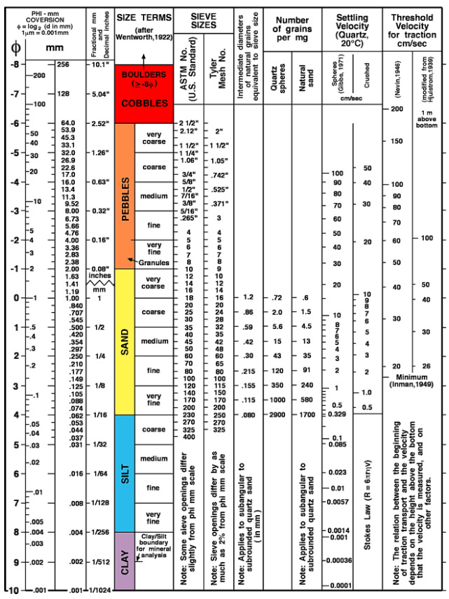
Tamanho do grão
Tamanho do grão, designa o diâmetro equivalente de partículas (grãos) de sedimentos clásticos (produtos de meteorologia e rearranjo mecânico) e partículas do solo. São utilizadas várias classificações de tamanho do grão. A classificação granulométrica de acordo com DIN 4022 distingue entre argila, lodo, areia, cascalho e pedras. A classificação da granulometria de acordo com Udden & Wenthworth, modificada após Doeglas, inclui argila, lodo, areia, grânulos, seixos, calhaus, calhaus e pedras. As duas escalas mencionadas usam milímetros como a unidade. Uma escala aritmética é a divisão do tamanho dos grãos de acordo com Phi como uma transformação logarítmica da escala Udden-Wenthworth.
onde d = tamanho do grão em milímetros. Os tamanhos dos grãos podem ser determinados por vários métodos, tais como a análise de peneiração, análise de sedimentação ou métodos ópticos. Deve-se ter sempre em mente que, ao determinar a partir de secções finas, apenas uma secção bidimensional é registada, o que pode causar problemas consideráveis com formas de grão mais complicadas. O método padrão para determinar o tamanho dos grãos em secções finas é o método das secções das cordas. A seguinte classificação de acordo com o tamanho médio do grão tornou-se internacionalmente aceite para análise do terreno: granulado fino: 1 mm, granulado médio: 1-5 mm, granulado grosso >5 mm. Na Alemanha, a classificação do tamanho do grão para as rochas cristalinas de acordo com Teuscher é também comummente utilizada.
Mas agora à areia e à sua classificação
A SUA TAREFA PARA A CACHE:
1) Quantos tipos de sedimentos encontra?
Ordenar os sedimentos utilizando a escala de Wentworth.
2) Examinar cada um dos sedimentos com muito cuidado e verificar qual o mineral que é.
A) Monominerais (consistindo de apenas um tipo de material).
B) Poliminerais (que consistem em vários tipos de material).
3) Passe a areia seca pelas suas mãos e agora toque nas suas mãos. Que sensação de pele permanece?
A) A sensação como se as suas mãos tivessem sido enrugadas com lixa.
B) A sensação de açúcar de confeiteiro entre os dedos.
C) A sensação de estar húmido, ainda que as suas mãos estivessem secas antes.
Descreva nas suas próprias palavras porque é que isto é assim.
4) Tirar uma selfie no (ou diretamente em frente ao) naufrágio do Cabo de Santa Maria (não apenas a partir da praia).
e se gostar opcionalmente de um coração na areia, incluindo a data.
Exemplo:

Claro que estou feliz com todas as outras fotos publicadas para acender a febre da viagem.
Espero que gostem desta CE e que se divirtam muito na praia da Boa Vista.
Enviem-me as vossas respostas e a foto através do centro de mensagens.
Se tudo estiver correcto, receberá de mim uma autorização de registo o mais rapidamente possível.
Se não receber quaisquer respostas ou se a foto não estiver disponível, terei infelizmente de apagar as vossas inscrições.
.........................

Willkommen am Strand vor der Nordwestküste Afrikas
Willkommen auf der kapverdischen Insel Boa Vista
Boa Vista ist eine der kapverdischen Inseln vor der Küste Westafrikas. Sie ist für die Sanddünen und mondähnlichen Vulkanlandschaften der Wüste von Viana bekannt. Zu den weißen Sandstränden gehören Tortuga und Santa Monica. Meeresschildkröten nisten am Ufer und Buckelwale ziehen auf ihrer Wanderung an der Küste vorbei. Auf einer kleinen Insel vor der Stadt Sal Rei befindet sich eine Burgruine aus dem 19. Jahrhundert.
Das hat mich zu der Idee gebracht hier einen EC zu diesem Thema auszulegen.
So hoffe ich hier einen lehrreichen EC anzubieten zu können der Euch Spaß macht.
Hier nun einige allgemeine Informationen zu diesem Küstenbereich:
Ihr befindet Euch am Sand-Strand auf Boa Vista mit Blick auf das Wrack der "Cabo Santa Maria"
Leider ist nur noch großer rostiger Haufen von der "Cabo Santa Maria" übrig. Sie ist im Jahre 1968 vor der kapverdischen Insel Praia Boa Esperança auf Grund gelaufen und ist bis heute eine beliebte Attraktionen, denn sie liegt nah an Land. Das war auch das Glück der Besatzung, die das Manöver überlebte. Selbst die Fracht konnte komplett ausgeliefert werden. Wer das Wrack besuchen möchte, muss allerdings erst durch eine recht unwirtliche Landschaft. Das geht entweder per Geländewagen über eine holprige Pflasterstraße oder zu Fuß ab Sal Rei. Mehrere Trampelpfade führen ab hier zur "Cabo Santa Maria". Die Laufzeit pro Strecke beträgt zwischen 1 ½ und zwei Stunden, am besten starten Sie früh, um die Mittagshitze zu umgehen.
Hier bei diesem EC geht es aber um das worauf ihr gerade steht, dem schönen hellen Sand!
Korngröße
Korngröße, bezeichnetden Äquivalentdurchmesser von Teilchen (Körnern) klastischer Sedimente (Produkte von Verwitterung und mechanischer Umlagerung) und Bodenpartikeln.Es werden verschiedene Korngrößeneinteilungen verwendet. Die Korngrößeneinteilung nach DIN 4022 unterscheidet Ton, Schluff (Silt), Sand, Kies und Steine. Die Korngrößeneinteilungnach Udden & Wenthworth, modifiziert nach Doeglas, beinhaltet clay (Ton), silt (Silt), sand (Sand), granules, pebbles, cobbles (Kies) und boulders (Steine). Die beiden genannten Skalen benutzen als Einheit Millimeter. Eine arithmetische Skala ist die Korngrößeneinteilung nach Phi als logarithmische Transformation der Udden-Wenthworth-Skala.
wobei d = Korngröße in Millimetern. Korngrößen können mit unterschiedlichen Methoden bestimmt werden, wie z.B. durch Siebanalyse, Sedimentationsanalysen oder optische Verfahren. Zu bedenken ist stets, daß bei der Bestimmung aus Dünnschliffen nur ein zweidimensionaler Anschnitt erfaßt wird, was bei komplizierteren Kornformen erhebliche Probleme erzeugen kann. Standardverfahren zur Bestimmung von Korngrößen im Dünnschliff ist das Sehnenschnittverfahren. Folgende Einteilung nach der mittleren Korngröße hat sich für die Geländeansprache international weitgehend durchgesetzt: feinkörnig: 1 mm, mittelkörnig: 1-5 mm, grobkörnig >5 mm. In Deutschland auch gebräuchlich ist die Korngrößeneinteilung für Kristallingesteine nach Teuscher.
Doch nun zum Sand und seiner Klassifizierung
EURE AUFGABE ZUM CACHE:
1.) Wie viele Arten von Sedimenten findest Du?
Sortiere bitte die Sedimente anhand der Wentworth-Skala.
2.) Untersuche jedes der Sedimente sehr genau und prüfe um welches Mineral es sich handelt.
A) Monominerale (bestehend aus nur einer Materialart)
B) Polyminerale (bestehend aus mehreren Materialarten)
3.) Lass trocken Sand durch die Hande rieseln, nun Hände abklopfen. Welches Hautgefühl bleibt ?
A) Das Gefühl als wären die Hande wie von Schleifpapier aufgeraut.
B) Das Gefühl von Puderzucker zwischen den Fingern
C) Das Gefühl von Feuchtigkeit obwohl die Hände vorher trocken waren.
Beschreibe in eigenen Worten warum dieses so ist.
4.) Erstelle für den Log ein Logfoto mit Dir auf/vor dem Wrack der Cabo Santa Maria ( nicht nur vom Strand aus ) und wenn Du möchtest Optional auch ein Herz im Sand inkl. Datum.
Beispiel:
Natürlich freuen ich mich über jedes weitere eingestellte Foto um das Reisefieber zu entfachen.
Ich wünsche Euch viel Spaß bei diesem EC & eine schöne Zeit am Strand von Boa Vista.
Schickt mir Eure Antworten und das Foto, über das Nachrichten Center zu.
Ihr werdet dann zeitnah von mir, wenn alles stimmt, eine Logfreigabe bekommen.
Sollte ich keine Antworten erhalten oder das Logfoto fehlen, werde ich leider Eure logs löschen müssen.
.........................

Welcome to the beach off the northwest coast of Africa
Welcome to the Cape Verde island of Boa Vista
Boa Vista is one of the Cape Verde islands off the coast of West Africa. It is known for the sand dunes and moon-like volcanic landscapes of the Viana Desert. White sand beaches include Tortuga and Santa Monica. Sea turtles nest on the shore and humpback whales pass by on their migration along the coast. A ruined 19th-century castle is located on a small island off the town of Sal Rei.
This has brought me to the idea here to lay out an EC on this topic.
So I hope to be able to offer here an instructive EC that makes you fun.
Here now some general information about this part of the coast.
You are on the sandy beach on Boa Vista with a view of the wreck of the "Cabo Santa Maria".
Unfortunately, only large rusty pile of the "Cabo Santa Maria" is left. She ran aground in 1968 off the Cape Verdean island of Praia Boa Esperança and is still a popular attraction today because she is close to land. This was also the luck of the crew, who survived the maneuver. Even the cargo could be delivered completely. However, anyone wishing to visit the wreck must first pass through a rather inhospitable landscape. This can be done either by off-road vehicle over a bumpy paved road or on foot from Sal Rei. Several trails lead from here to the "Cabo Santa Maria". The running time per route is between 1 ½ and two hours, it is best to start early to avoid the midday heat.
But here at this EC it's all about what you're standing on right now. The bright sand!
Grain size
Grain size is the equivalent diameter of particles (grains) of clastic sediments (products of weathering and mechanical rearrangement) and soil particles. The particle size classification according to DIN 4022 distinguishes between clay, silt, sand, gravel and stones. The grain size classification according to Udden & Wenthworth, modified after Doeglas, includes clay, silt, sand, granules, pebbles, cobbles and boulders. Both of the above scales use millimeters as the unit. An arithmetic scale is the grain size division according to Phi as a logarithmic transformation of the Udden-Wenthworth scale.
where d = grain size in millimeters. Grain sizes can be determined by different methods, such as sieve analysis, sedimentation analysis or optical methods. It should always be borne in mind that when determining from thin sections, only a two-dimensional section is recorded, which can cause considerable problems with more complicated grain shapes. The standard method for determining grain sizes in thin sections is the chordal section method. The following classification according to mean grain size has become widely accepted internationally for terrain analysis: fine-grained: 1 mm, medium-grained: 1-5 mm, coarse-grained >5 mm. In Germany, the grain size classification for crystalline rocks according to Teuscher is also commonly used.
But now to the sand, and its classification
YOUR TASK FOR THE CACHE:
1.) How many types of sediments do you find?
Please sort the sediments according to the Wentworth scale.
2.) Examine each of the sediments very carefully and check which mineral it is.
A.) Monomineral (consisting of only one type of material)
B.) Polyminerals (consisting of several types of material)
3.) Let dry sand trickle through your hands, then pat hands. What feeling remains on the skin?
A) The feeling as if the hands were roughened by sandpaper.
B) The feeling of powdered sugar between the fingers.
C) The feeling of moisture, although the hands were dry before.
Describe in your own words why it is like that.
4.) Create a log photo for the log with you on/in front the wreck of the Cabo Santa Maria ( not only from the beach ) "Not from the beach but in the water when safe to do so." and, if you want Optionally also a heart in the sand incl. the date.
Sample:
Of course, I am happy about every other posted photo to spark the travel fever.
I wish you a lot of fun with this EC & a nice time at the beach of Boa Vista.
Send me your answers and the photo via the message center.
You will get a log release from me, if everything is correct.
If I don't get any answers or the log photo is missing, I will have to delete your logs.
.........................
Se quiser, pode adicionar o banner ao seu perfil.
Wer möchte kann das Banner in sein Profil einbauen.
Whoever wants to can add the banners to their own profile.

Basta adicionar o seguinte código ao seu perfil:
Füge dazu einfach folgenden Code in Dein Profil ein: / Just add the following code to your profile:
<a href="http://coord.info/GC9Y6Q0" target="_blank"><img src="https://img.geocaching.com/cache/large/fc7e0d79-fccb-4155-bc14-e4fb0a5ede1e.jpg" border="0" /></a>
Há uma pequena mesa para os três primeiros descobridores!
Für die ersten drei Finder gibt es eine kleine Tabelle! / For the first three finders there is a small table!
1.) BoldFont
2.) Aušrys
3.) PHIL / TRIX
