Footerin' Aboot: Nothing to do with football, nor the text at the bottom of a page; this is local dialect, it means to pretend to look busy, but in reality, messing around achieving little, delaying, wasting time.
However you'll not be wasting your time doing this multi, as you'll find out something about this area and its history.
Fountainbridge:
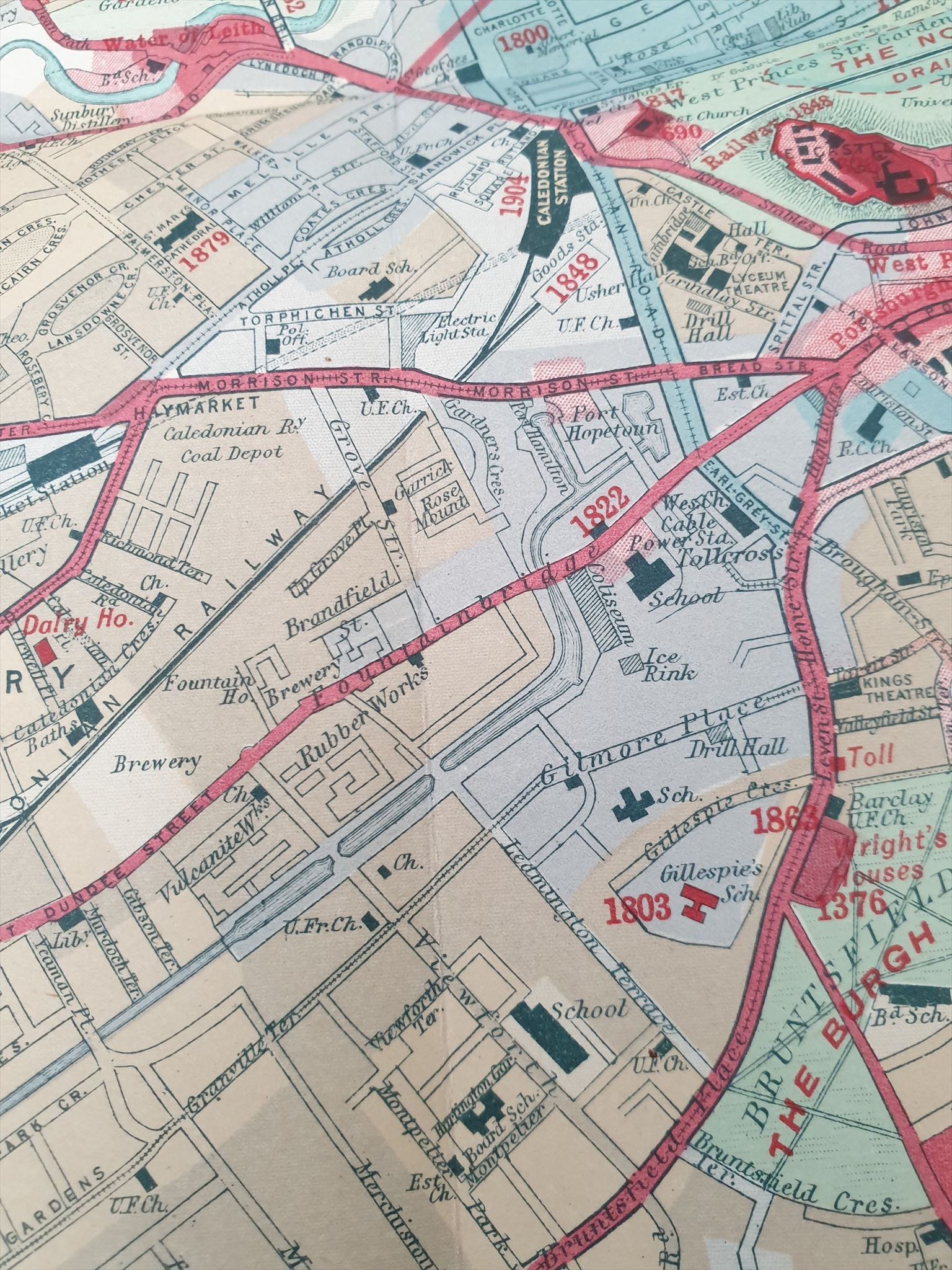
This is a segment from an 'isochronic' map. The very deep red colour, such as at the castle at the top right of the picture, depicts things that were there prior to 1450. Deep pink is 1450 to 1515, that is the 3 roads going out from the West Port. The Union Canal and its basins are in pale blue, which indicates after 1750. Notice the rubberworks and breweries in a peach colour which indicates later than 1850, and is the era of most interest in this History Multi.
Fountainbridge is an area of Edinburgh that lies south of Princes Street. It is bounded by Haymarket to the north, Tollcross to the east, Merchiston to the south, and Gorgie/Dalry to the west. For council administrative purposes, it is taken together with Tollcross.
You’d be forgiven for thinking that the name Fountainbridge is connected somehow to the nearby Union Canal which was opened in 1822.
The name, however, is older than this. There are documents from 1512 naming the area Foullbridge and actually refers to a crossing over the Dalry Burn, which was also known as the Foul Burn, a tiny stream used as a sewer that connected the Boroughloch to the Water of Leith. It ran from the Boroughloch through Lochrin and over towards Coltbridge. From around 1760 the bridge was rechristened Fountainbridge.
The ‘fountain’ in the name, by the way, does not refer to a dramatic plume of water shooting upwards from a pool: which is an image erroneously used by businesses around the place: it means a drinking fountain or well. It was in Grove Street.
Historically, this was the main route between Glasgow and Edinburgh. In earlier times, the City of Edinburgh extended westwards from the Old Town only as far as the West Port. A small suburb called Portsburgh grew outside the city gate around the 17th century. At the end of Portsburgh the road split into 3: one going to Stirling; it is now Bread Street. One went to Glasgow; this was Fountainbridge. The third one went to Peebles; this is now High Riggs.
The history of Fountainbridge is long and fascinating for anyone with an interest in social history and our industrial heritage. It has been your CO's pleasure to attempt to untangle some of it to create this multi. Most of the buildings are gone now, so this tour will inevitably take you to where they used to be; I hope it is still an enjoyable tour.
There have been remarkable changes over a relatively short time: this can be summarised in 3 stages thus:
1: Prior to the 19th century: it was mainly rural farmland and orchards owned by a handful of rich landowners, with a few great houses such as North Merchiston House, (it was in Bryson St), and Banefield House, (it was in Gibson Terrace). During the 17th century a few houses began to appear near the West Port.
2: 19th to 20th centuries: The opening of the Union Canal heralded an explosive growth of heavy industry. By 1836, the canal was fully established and had 3 basins at this end: Port Hopetoun, Port Hamilton and Lochrin. The canal's importance subsided somewhat with the opening of the Caledonian Railway in 1848 but industry continued, and in turn, the railway was overshadowed by the opening of the West Approach Road in 1974. Certainly by 1922, all 3 canal basins had been filled in, then the railway closed (the station was where the Sheraton Hotel and Festival Square now are).
In its heyday, Fountainbridge was home to many industries, too many to mention here; and most of those buildings are gone. Worth mentioning are:
Brewing and Distilling: There were once 40 of them! including: McEwan's, Younger's, Usher's, Dryborough, Gillespie's, Campbell Hope and King, Steel and Coulson, Lorimer's. They were close to each other, grouped around the canal. These breweries ran, of course, on coal brought in by canal boat; probably contributing to Edinburgh's nickname of 'Auld Reekie'.
Foundries and Metalworks, such as James Learmonth and co; Bainfield Iron and Wire Works; Caledonian Engine Works; Etna Iron Foundry;
Gilmore's Rope Works;
North British Rubber Works;
Castle Silk Mills;
Several Coalyards
Most of these are gone now, except for Caledonian Brewery, in Slateford Rd, which is a descendant of McEwans.
Some of these remarkable industries will be mentioned in more detail along the way.
3: Modern times: The industrial age is over and Fountainbridge, along with Tollcross, the West End and Edinburgh Park, is now home to Edinburgh's significant financial and banking industry, with big names galore. At the Exchange District you will find numerous blue chip financial, technological and professional businesses. But this multi is all about the past!
PRACTICALITIES
You can of course visit each waypoint in any order you like, but I'd recommend the order given as being the most economical with time and energy, and proximity to the final location too! There are lots of places to eat and drink along the way and the terrain is simple. There are some cobbles so Wheelers and Cyclists may want to take that into account. Parking is terrible..... sorry! Most of the side streets are in Parking Zone S4 with payment required from 08:30 to 17:30 Monday to Friday, but if you park at Fountain Park, AND visit one of the outlets there, you can have your ticket stamped to permit free exit. Peedieduchess usually takes the bus to Tollcross and walks from there, taking a comfort break at Waypoint 5 (Fountain Park).
The route from Waypoint 1 to Waypoint 10 takes about 1 hour to walk.
Please keep good records, no promises, but there may be a bonus cache (much) later.
OK. Let's Footer Aboot....
Note: I know that some of the answers can be found on google street view and on the internet; do so with my blessing but don't miss out on a nice tour!
WAYPOINT 1 : Sheep's Plucks and Bags, Port Hamilton N 55° 56.673' W 3° 12.456

We start our history tour at the most modern development: wedged in and surrounded by Haymarket, Tollcross and Fountainbridge, here are some posh office buildings and businesses, yet the builders have memorialised the history of the place by erecting an interesting panel detailing the history of Fountainbridge and the meat trade. This is the old Port Hamilton, one of the 3 ports that terminated the Union Canal. It was named after the Duke of Hamilton, who owned coalfields in the West of Scotland, and Port Hamilton was the depot for the coal brought from the west by barge to Edinburgh, to fuel the heavy industry.
Everything you ever wanted to know about the livestock trade is right here on the information panels.
QUESTION TO ANSWER: What year was the photo taken? = A
WAYPOINT 2: The Meat Market N 55° 56.636' W 3° 12.438
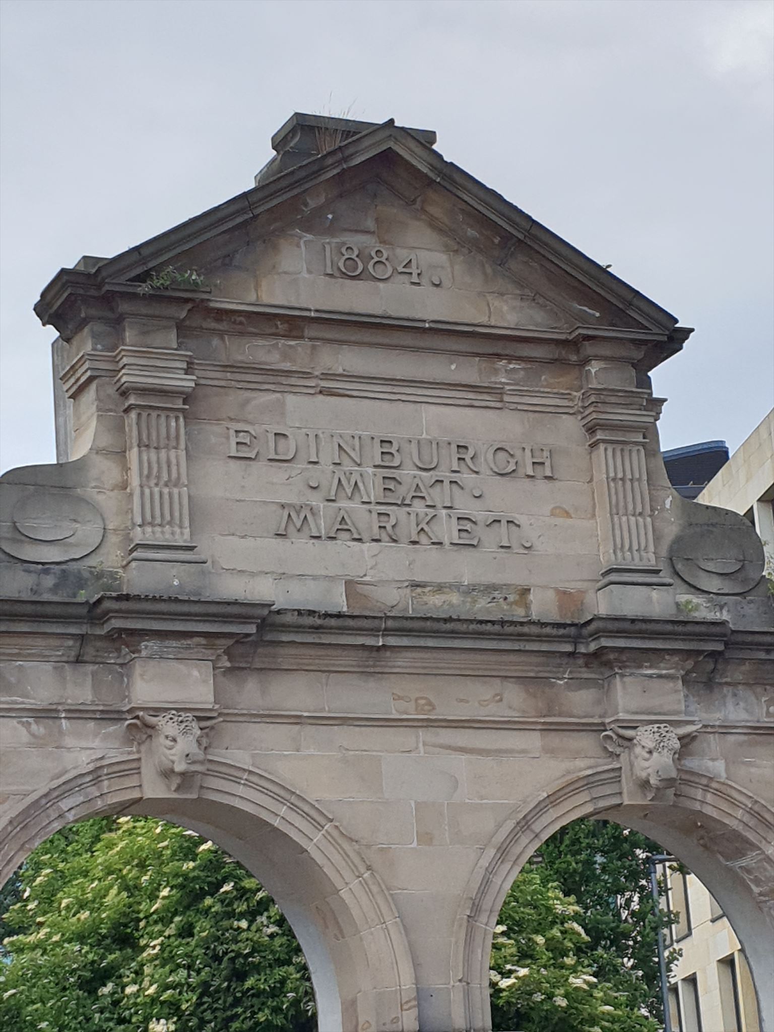
Here is the site of the old meat market, and only this arch remains. It was moved slightly from its original position. Have a look at the plaque on the ground in front of the arch. Can you imagine what it was like here: and the smell! There would have been cattle, sheep, pigs, being herded up the street from the Grassmarket to the slaughterhouse at Ponton Street, just across the road where Tollcross primary school now is, and the noise and bustle of the sales in the building that stood here. Goods, alive or not, were transported by barge on the canal.
Prior to the slaughterhouse at Fountainbridge, many of the city’s abattoirs and meat markets were in the Old Town, hence street names such as Fleshmarket Close and Cowgate. Discharge from the abattoirs flowed directly into the putrid Nor’Loch. During the 1800s the production of meat was relocated away from the city centre in the interests of public health. The area chosen for relocation was Fountainbridge, formerly the site of farmhouses and orchards, but fast becoming the industrial heartland of Scotland’s capital since the opening of the Union Canal in 1822.
Notice the sculpted bull heads on the arch.
As the 20th century approached, slaughtering cattle close to residential areas was becoming increasingly unpopular, so the slaughterhouse was moved in 1909 to a new purpose-built site at Chesser. The Edinburgh Meat Market continued to operate on Fountainbridge, however, its days were numbered. It too eventually relocated to Chesser in 1921.
QUESTION TO ANSWER:
What is the year on the BACK of the arch? = B
NOTE: CHANGE OF QUESTION DUE TO REPAIRS TO THE ARCH: Look across the road to find the date high up on the building, above door no. 111
WAYPOINT 3: St Cuthbert's N 55° 56.605' W 3° 12.493

The coordinates take you to a bus stop across the road from a cafe called Loudon's. This building was the headquarters of St Cuthbert's Co-Op from 1880. This innovative trading mode, which gave dividends to customer members, began on a small scale in 1859, and expanded with more and more stores opening and selling not only drapery, but also coal, food, bakery, milk deliveries, furniture, funerals etc.....It even purchased Cliftonhall Estate to start a farm. in 1943, a local 13 yr old lad called Sean ‘Tam’ Connery got his first job with St Cuthbert's as a barrow-pusher, then later on, after doing his National Service, he came back for a couple of years as a milkman. St Cuthbert's was an early adopter of 'self service' shopping. Directly opposite here there used to be the Palais de Danse where ‘Big Tam’ was a popular dance partner. It is now student accommodation. One of the bands who played there was Manfredd Mann.
In 1981 St Cuthbert's merged with other societies across the central belt to form Scotmid, inlcuding the Dalziel co-op where Peedieduchess had a Saturday job working on the fruit and veg counter as a schoolgirl in Motherwell. Her mum was delighted with the staff discount!
Scotmid continued delivering the milk by horse and cart right up until 1985!
Peedie can still remember her mum's 'divi' number.......
QUESTION TO ANSWER: What is the date, away up high and left, best seen from the bus stop across the road from Loudon's = C
NOTE: not the date above the door
Waypoint 4: Lochrin Basin and the Millenium Link N 55° 56.573' W 3° 12.479
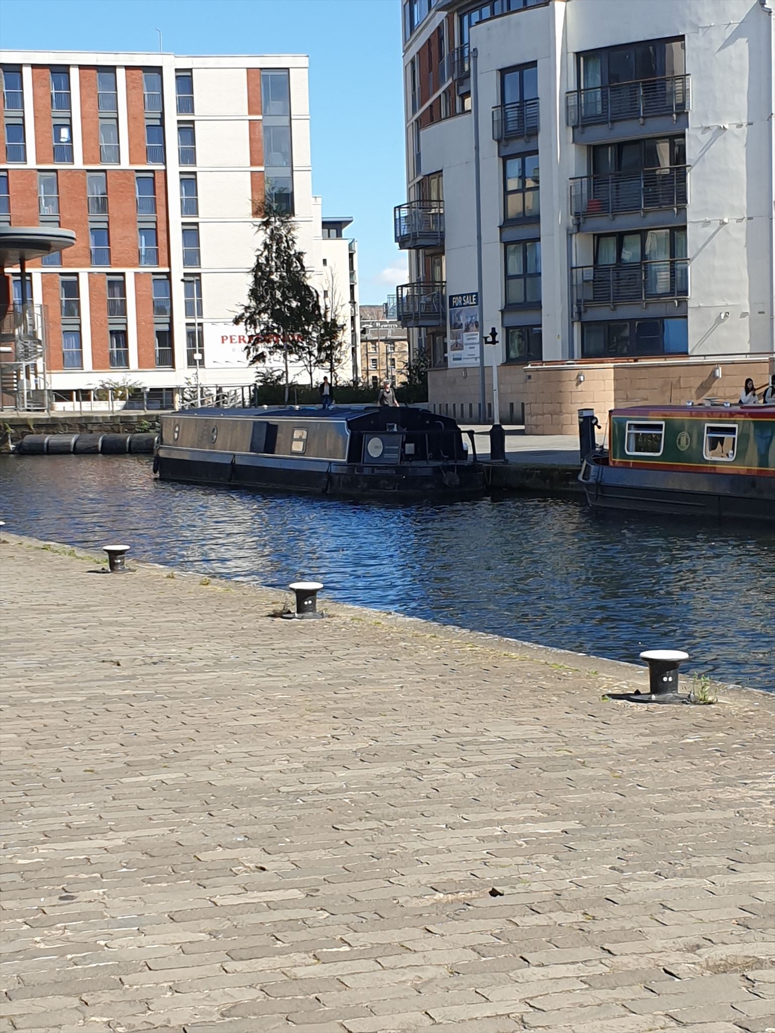
Course of the Union Canal
Do you remember that the Union Canal used to have 3 terminal basins? Port Hamilton, Port Hopetoun, and Lochrin. Port Hopetoun was filled in in 1922 and in its place is Lothian House, which you can read about in another multi Toddle Around Tollcross. Port Hamilton was also filled in in 1922 and was built over, you have seen the newest incarnation at Waypoints 1 and 2. As for Lochrin: its the only one remaining, the canal now stops right here. There isn't scope here to explore the full history of the Union Canal, so briefly just to orientate you:
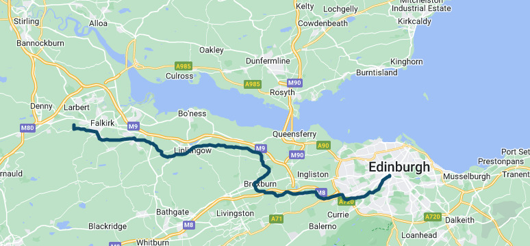
The Forth and Clyde Canal links the River Clyde to the River Forth, across Scotland west to east, reaching the Forth at Falkirk, where it joins the river at Grangemouth via the River Carron. It opened in 1790, funded partly by funds from confiscated Jacobite estates. It was owned by the Caledonian Railway company, then the British Transport Commission. The Union Canal is an extension from Falkirk to Edinburgh, a distance of just over 30 miles, opened in 1822, mainly to transport coal to the City from the western coal fields. All commercial traffic on the Union Canal ceased in 1933, and the Forth and Clyde Canal was closed in 1963, but a huge project called the Millenium Link restored it and it reopened in 2001.
You can read all about it on the information panels here and also along the canal path. You can even buy a coffee from a cafe barge!
The name Lochrin comes from the Loch Rin, the stream that drained the Borough Loch into the Water of Leith. Lochrin Basin has become the focal point of the gentrified Exchange and Quay districts, and you can see the offices, expensive housing, canal boats, and lots of student accommodation. During the excavation work to build this, workmen came across evidence of medieval buildings, an old ice rink, a garage, and Lochrin Distillery, and the archeological record clearly demonstrated the transition from early agricultural use to industrial use.
As you walk along the canal path to Waypoint 5, take the time to have a look at the information boards and art work by local schoolchildren.
QUESTION TO ANSWER: How many swans are there? = D
Waypoint 5 Leamington Lift Bridge N 55° 56.479′ W 3° 12.670


http://canmore.org.uk/collection/1071699
The bridge was first located in Port Hopetoun1906 and moved in 1923 when Port Hopetoun was closed. The wooden deck weighs 40 tons and is lifted up by 4 cables supported by the towers. 2 counterweights, 17 tons each, provide the 'lift'. Before this, there was a manually operated wooden bridge. Have a look at the west side of the bridge: it says 'The Mathematical River'. Why? It's because the canal was craftily built along contour lines, so that no locks are required, until you get to Falkirk where the amazing Falkirk Wheel does its thing, closely supervised by the fabulous Kelpies.
QUESTION TO ANSWER: Have look at the old winch. How many teeth are there on the smaller cog? = E
To get to from waypoint 5 to waypoint 6, I recommend that you stay on the canal path, walk under the 1st bridge, then about half way between the 1st and 2nd bridge, leave the canal at Gibson Terrace. There is no exit from the canal path at the 2nd one, Walker Bridge.
As you are passing under the 1st Bridge, which carries Viewforth over the canal, notice the carvings on the bridge: the one on the east side is the coat of arms of Edinburgh, and the one on the west side is of Glasgow. Also admire the brand new Boroughmuir High School, with its roof top basketball pitch.
Waypoint 6 Fountainbridge Library N 55° 56.430' W 3° 13.119
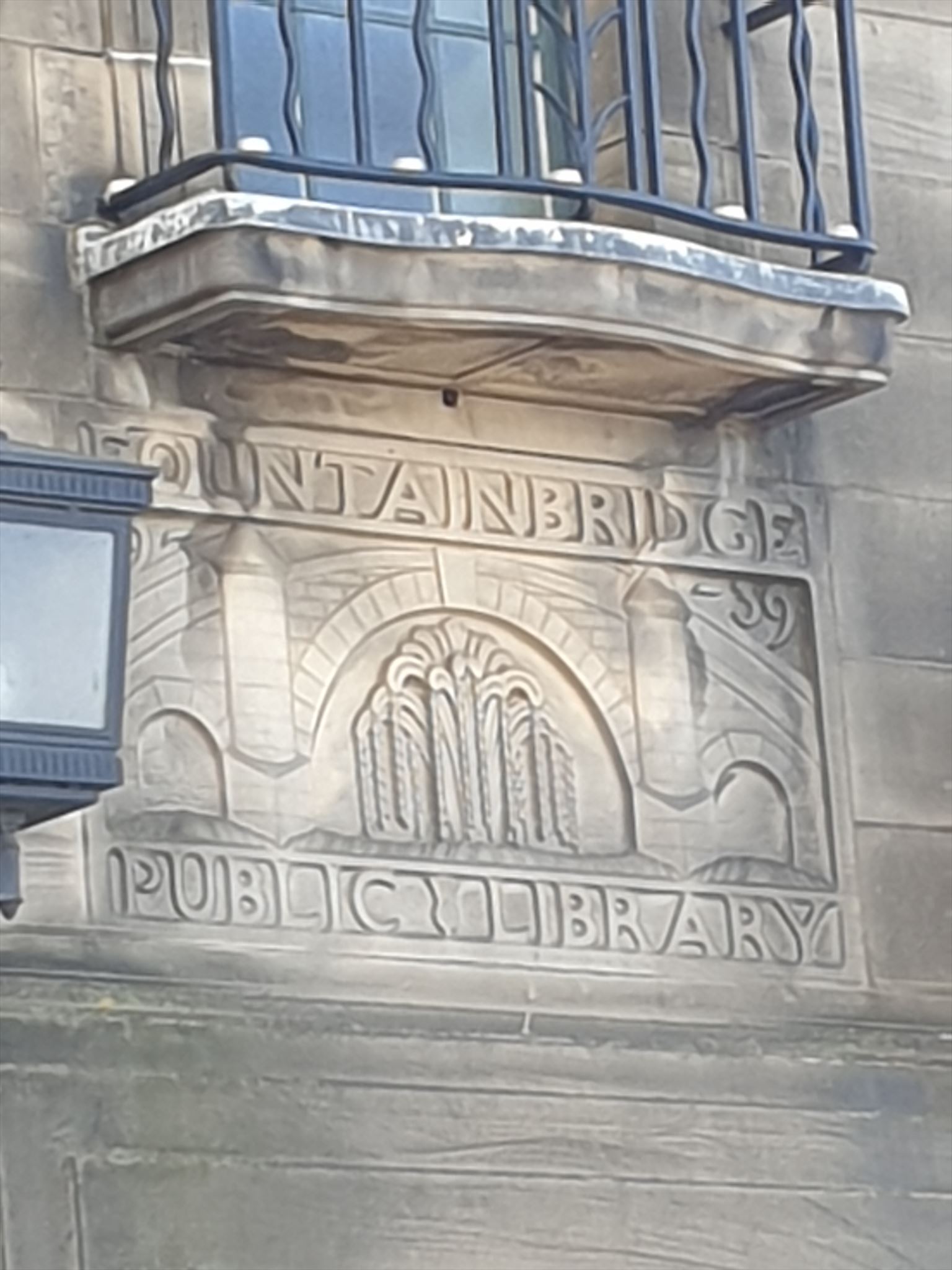
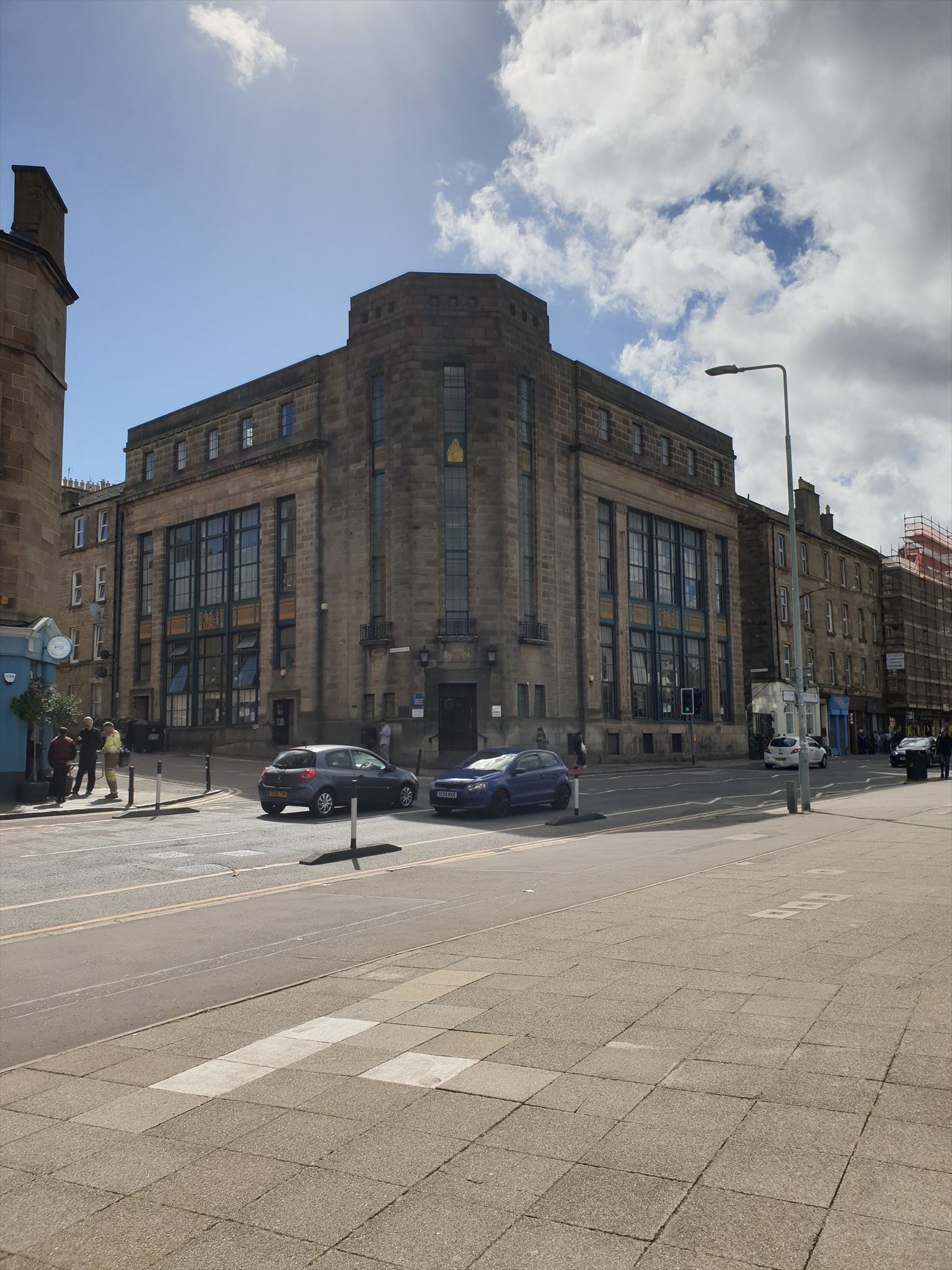
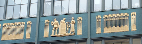
The coordinates take you to some steps across the road from the library where you can get a good view. The library is an example of modern Scottish architecture by Alexander Grant and was opened in 1940, although the stone carving of a fountain and a bridge, above the door, says 1939. The most notable features are, the chamfered entrance, the sculpted panel over the door by Charles d’Orville Pilkington Jackson, (he was more famous for the statue of Robert the Bruce at Bannockburn, and for many war memorials), the octagonal stairwell and skylight, and the bronze-plated cast iron panels, which show ordinary working people wearing their everyday clothes, supposedly to indicate that the library is there for everyone. All around the building and on the panels are rows of papyrus. There is a secret ladder that leads to a room away above the skylight: it has a 360º view over the city right across the Forth to Fife and was used as a lookout tower during WWII. During the war, the library had to close at dusk because it did not have blackout curtains for the huge windows.
QUESTION TO ANSWER: Look at the mural.....what number is on the bus stop? This answer is F
Waypoint 7: McEwan's Brewery/Fountain Park N 55° 56.482' W 3° 13.025

The Fountain Brewery, owned by William McEwan, was established here in 1856; it was a site chosen for its proximity to the canal, the railway and a plentiful water supply. It had several buildings alongside the canal, but the biggest one was here on the site of the leisure and cinema complex. McEwan also owned the Boroughloch Brewery and they merged in 1931 with Youngers then created Scottish & Newcastle Brewers in 1960. In 1973, as a result of a £13 million investment, a new Fountain Brewery was opened on the south side of Fountainbridge on the former site of the North British Rubber Company's premises (see Waypoint 8), where the hose factory was converted to a bottling plant. The whole of the brewing 'campus' was demolished in the early 21st century to make way for the Edinburgh Quay development. The only one left is Caledonian Brewery in Slateford Road.
QUESTION TO ANSWER: How many rings or 'bubbles' are there above the entrance sign = G
On your way to Waypoint 8, be sure to look at the cartoons about James Bond 007 on the hoardings.
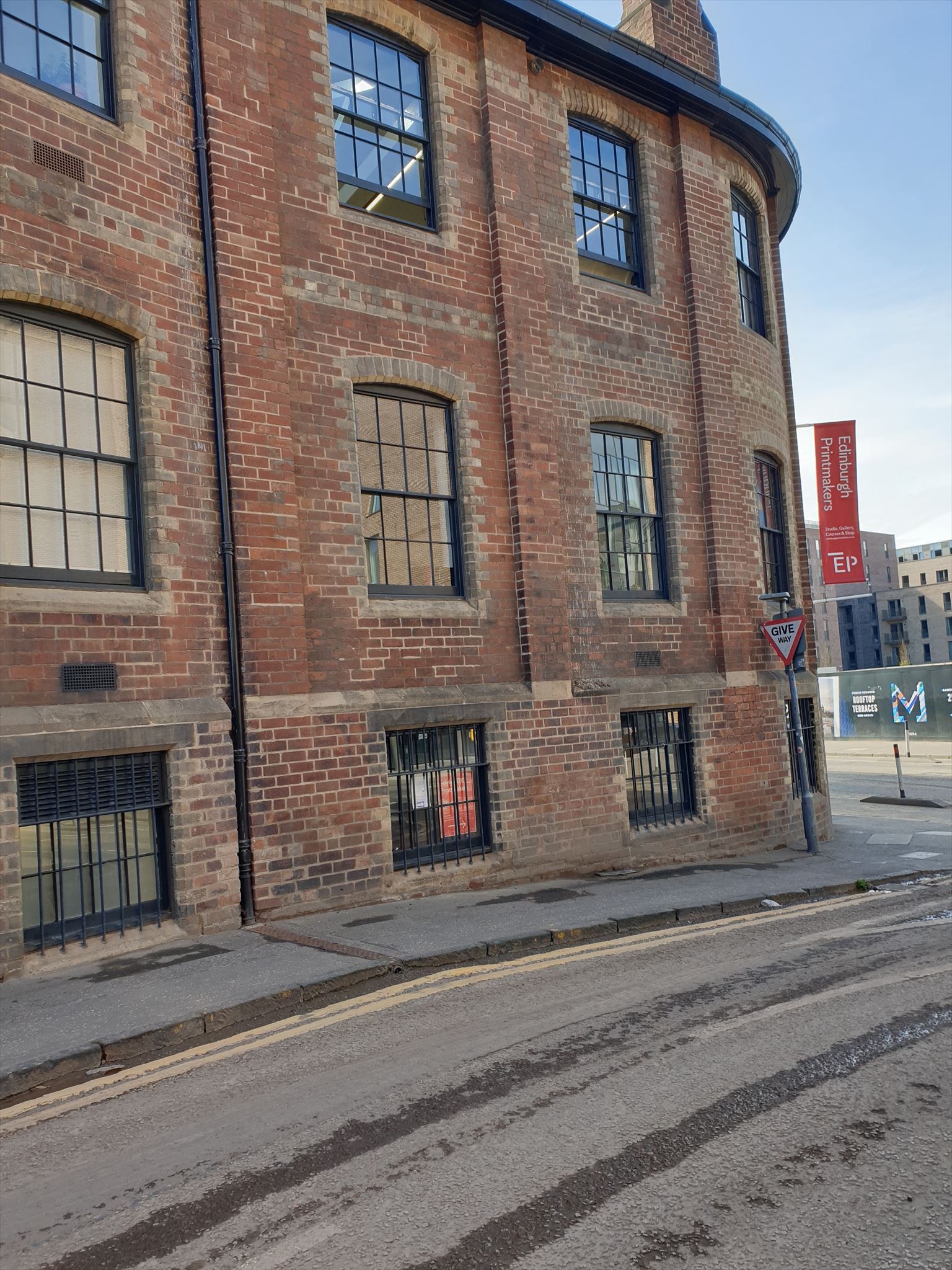
Waypoint 8: Silk, Rubber, Tartan Special and Art N 55° 56.539' W 3° 12.787'
This building originally belonged to Castle Silk Mill, established in 1836 by William Casey. It was not successful, owing in part to competition from Paisley, and in part to silk worm disease. The main entrance was on the canal side; water from the canal was used for cooling.
Meanwhile, in America, Charles Goodyear invented 'vulcanisation' so making it possible to produce waterproof rubber.
Henry Lee Norris came from America in 1856 to begin rubber production; this building was the HQ, but there were 3 larger premises. They made a huge number of different articles, such as wellington boots, garden hoses, hot water bottles, golf balls, and tyres. During WWI they made gas masks and barrage balloons, and again in WWII they made gas masks and soldier's boots. They worked 24 hrs a day for the war effort. In 1958 they supplied the first ever traffic cones: for the M1. The tyre production moved out to Unilever at Newbridge, but the hose factory remained a bit longer, till around the early 1970s.
After that, Scottish and Newcastle breweries used it as a bottling plant. In the early 1970s, the brewery opened the Tartan Club nearby. It was a social club for staff, and also had a sports hall with badminton and 5-a-side football. They also had a mobile bus: a trailer painted in the Tartan Special livery that travelled around to parties all over Scotland and the North of England.
The building is now the home of the Edinburgh Printworks, with the help of National Lottery money.
Inside the printworks is a gallery with a floor made of rubber, and reliefs depicting some political figures.
QUESTION TO ANSWER: In what year was Rachel born? = H
Stage 9 : Licensed to Kill N55 56.556 W003 12.767
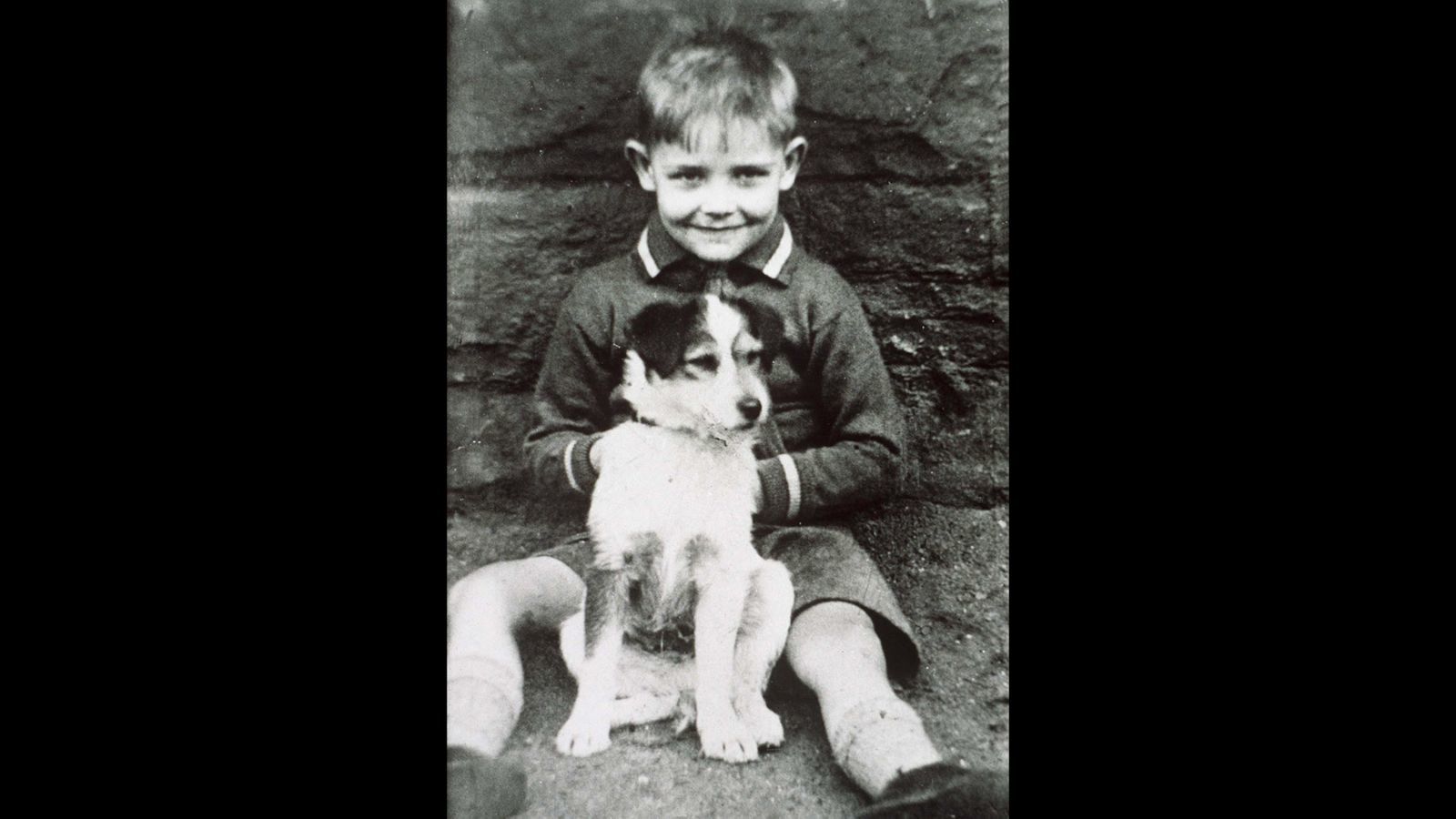
Sir Sean Connery, 1930-2020, one of the most famous sons of Edinburgh and indeed Scotland. He grew up at no.176 Fountainbridge, it is now demolished, but there is a plaque on the side of a newer building in Melvin Walk. (why didn't they call it Sir Sean Connery Walk?). His first job was as a barrow pusher with St Cuthbert's co-op but he was better remembered as a milkman with a horse-drawn float. His theatre and film career started in a small way, working backstage at the King's Theatre; we all know the rest!
QUESTION TO ANSWER: Convert the LAST letter on the plaque to a number = J
Waypoint 10: Experimental Housing N 55° 56.720 W 3° 12.624


Along with this enormous industrial production, the people lived in tenements that were, frankly, by the end of WWI, notorious slums, which were subjected to slum clearances in the 1950s and 60s. Over 16,000 houses were demolished. But this was nothing compared with the miserable housing of working people in the 19th century. Outbreaks of diseases such as cholera were associated with overcrowded, unsanitary conditions in the Old Town. In 1850, the Edinburgh News described the old town houses as 'chambers of death'. Philanthropists and church leaders wanted to improve matters with a variety of schemes; one of those was the development of 'colony' houses, probably called that because they were outside of the old town. They were 2-storeys, an upper flat with 2 bedrooms and the lower flat with 1 bedroom; the entrance doors were on opposite sides so that both could have a small garden. The first such project was in Stockbridge; the second one was here in Gardner's Crescent.
By the way, the crescent itself was built around 1826 on the site of Gardener's Hall and was originally supposed to have another crescent facing it to from a 'circus', with the gardens in the middle; but that could not be done owing to the route of the railway.
Here in Gardner's Crescent you can see 2 examples of experimental social housing.
Rosebank Cottages, built in 1854, was the second of the 'colonies' style of dwelling. The cottages were built to provide homes for the workers at Rosemount Cabinet Works.
Also here is Rosemount Building, which comprised of 96 flats around a central quadrangle. It was designed by an architect, William Lambie Moffat, who was more used to building poorhouses. This building was unusual at the time because it is made from brick, not stone. It had polychrome bricks arranged in patterns around the windows and doors.
John Taylor & Son was a high-end furniture maker with a shop in Princes Street; the shop was next door to Debenhams, and is now a branch of River Island. Their Rosemount cabinet works in Gardner's Court was established in 1857, and employed 300 people. They went into liquidation in 1945. (if you are lucky enough to be perusing an antique shop or a jumble sale and come across a piece of furniture with the stamped 'John Taylor & Son, Edinburgh', snap it up, it could be worth a lot of money!).
By the way: Harry Potter author JK Rowling once lived at no. 28, Gardner's Crescent.
QUESTION TO ANSWER: what is the bottom number on the lamp post? = K
If you have been footerin' aboot more or less along the route given, you can sit in the gardens near Waypoint 10 to do some arithmetic to work out the location of the cache, which can be found at:
N55 56.PQR W003 1S.TUV
WHERE:
P = K
Q = add together the 1st digit of A,B,C,D and E, the last digit of B and the last digit of F
R = the 2nd digit of C minus the 2nd digit of H
S = J divided by K
T= add up the digits of F
U= add together all the digits from J and K
V= G minus 3
Need a checksum?
Your 7 numbers should add up to 35
You can also use the checker.

PLEASE use maximum stealth: try not to be observed when retrieving and replacing the cache.
I hope you have enjoyed your walk, learning a little bit about the history of Fountainbridge, from orchards and country homes, through heavy industrial production, a lot of beer, and ending with financial institutions.
This is the 10th of 12 local history multis, created by Peedieduches. There are also 2 bonus mystery caches. The others are:
First series: Gambol Through the Grange Second series: Sally into the Southside
Meander Through Marchmont Knocking around Newington
Saunter Through Sciennes Toddle Around Tollcross
Bimble Through Blackford Footerin' Aboot in Fountainbridge
Birl Through Bruntsfield Perambulate through Prestonfield
Mosey Through the Meadows Stravaiging around St Leonard's
There is a bonus mystery cache for the first series: Jig Through Half a Dozen History Multis
There is a bonus mystery cache for the second series: Jig Through another Half a Dozen multicaches
Happy Caching!
Peedie.
CONGRATULATIONS TO DEVIOUS_DWARFERKEV. 🥂 HE DIDN'T HAVE TO FOOTER ABOOT FOR TOO LONG BEFORE BEING THE FIRST TO FIND THE CACHE!