About the KMTA GeoTrail:
Welcome to a geocaching trail exploring Alaska’s only National Heritage Area. In 2009, Congress designated the Kenai Mountains-Turnagain Arm (KMTA) region of Southcentral Alaska as a National Heritage Area (NHA). This designation formally recognizes the history of an area that has deeply shaped the legacy of Alaska and the nation. It is the history of the Alutiiq, Sugpiaq, and Dena’ina people—the original stewards and inhabitants of the Kenai Peninsula. It’s that of the Iditarod National Historic Trail, Alaska Railroad, Gold Rush, Seward Highway, and local industries that give KMTA its character. KMTA’s geographic footprint bridges Cook Inlet and Prince William Sound via mountains, glacial valleys, and productive rivers. Throughout this landscape are communities and stories that connect us to our past and future. It includes the small and vibrant communities of Bird, Indian, Girdwood, Whittier, Hope, Cooper Landing, Moose Pass, and Seward, and all the wilderness between them. As Alaska’s only National Heritage Area, KMTA aims to enhance, preserve, and share the region’s natural and cultural resources— in essence its heritage. Above all else, KMTA strives to foster pride of place and an enduring stewardship ethic for this special place. As you travel through the Heritage Area to complete this GeoTrail, we encourage to keep that stewardship ethic front of mind as you learn about and enjoy the richness of the region.
As you search for the geocaches making up this GeoTrail, you’ll be asked to complete a passport that qualifies you to purchase the KMTA GeoTrail Geocoin. For more information on the Passport and GeoTrail, please visit KMTA-GeoTrail.GCAK.org
KMTA field guide link: https://kmtacorridor.org/field-trip-guide/
The unique code word for this cache is found on the front of the logbook and/or on the inside of the container lid.
**Cell coverage warning: this location may have limited cell phone coverage (at least for data). It would be wise to download the cache information before arriving at GZ.**
KMTA GeoTrail #11: Tern Lake: Geology and Effects of Road Construction
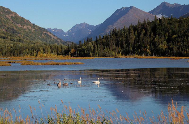
Location: TERN LAKE: Junction Sterling Highway and Seward Highway (approx Mile Post 38)
Short Description: This stop has two purposes: to observe a slow-motion sloughing of a mountain and confront what we take for granted actually was a result of human disturbance.
Field Trip Lesson Items: Photo of Mountain, Old Map of Area (attached below)
Suggested Equipment: Binoculars
Other Info:
- Mountain visuals will be obscured by low clouds.
- If desired, instead of the pull-off, a picnic area is located 1/4 mile down the Sterling Highway with pit toilets.
What’s Going On Here?

The Mountain behind Tern Lake:
This is a tough observation, however, take a look at the top third of the predominate mountain to the south. You’ll note a bulge a third of the way down the right (west) side of the mountain. Just another feature? Or is something going on? Something is going on. This section of the mountain is unstable and is slowly creeping down the mountainside. It likely has been happening for many, many ages. Likely it is a result of over-steepening of hillside by glacial scouring. However there will come a time (just like the hillside south of Hope Junction) where gravity will win. It isn’t without precedent. These massive failings have been famously documented many times such as in Lituya Bay and in Glacier Bay in the summer of 2012. Although not of those magnitudes, the collapse of this shoulder above Tern Lake would certainly have an effect in this valley.
But there’s more:
So, something happened between the time the map was drawn to now to create this lake. And that something was the construction and modernization of the Sterling and Seward Highways. These highways constricted the flow of water creating this lovely shallow lake. However, it perhaps wasn’t always lovely. Imagine what the area looked like prior to the succession of marsh plants. Perhaps the original name for Tern Lake would help— Mud Lake.

Perhaps it took awhile, however little did anyone realize during the construction phase that the resulting lake would be a favorite spot for swans in the summer, and skaters in the winter. Oh, and geocachers, too!
Seasonal access note: Cache may not be easily accessible during the winter due to burial by highway snow removal equipment.
This cache is maintained by local Alaskan geocacher SSO JOAT.
Please contact him with any questions or maintenance requests.