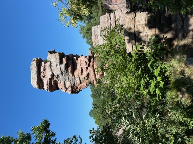
Balancing Rock is located in Palisades State Park which is in southeast South Dakota and is considered one of the most unique areas in the state. Split Rock Creek flows through the park and is lined with Sioux Quartzite formations that vary from shelves that are a few feet above the water to 50 foot vertical cliffs. The area is also a popular rock climbing destination.
Balancing Rock is considered a quartzite column and derives its name from how it appears to challenge gravity as it stands perched on the wall overlooking the creek. The Sioux Quartzite spires are estimated by geologists to be 1.2 billion years old. The park is on the southern edge of the Coteau des Prairies which is a series of glacial deposits that stretch for nearly 200 miles in eastern South Dakota. If you look closely at the rock, you may notice several unique and interesting features such as ripple marks, mud cracks, cross bedding, and jointing. Ripple marks (similar to what you may see in sand while at the beach) are plentiful in shale and Sioux quartzite formations and indicate that the current along the bottom of the lake or stream bed were strong enough to occasionally pile up undulating ridges of sand grains. We can go a little more in depth and there are two main types of ripple marks, symmetrical and asymmetrical. Symmetrical ripples are created by two way currents, meaning that the wave will hit the beach and then retreat. In contrast asymmetrical ripples are created by one way currents. The simplest way to tell the two apart is, like the name suggests symmetrical ripples look symmetrical and both sides are like a mirror image of each other. Asymmetrical ripples are not and one side of the ripple will be steeper than the other. Then there are mud cracks (think of photos you may have seen of places that have droughts where the ground is so dry that there are cracks) and are typical on shallow water lake shores or streams and result from the drying out and shrinking of clay. The cracks are preserved when they are filled in with a coarser or finer sediment after they have thoroughly hardened and dried. Cross bedding is also common (simplest way to describe it is as layers or rock that are on an angle and may alternate directions). The presence of cross bedding indicates that currents were periodically strong enough to transport a large amount of sand for a short distance before losing its force and piling it up on slopes. Lastly there is jointing, which refers to the well developed cracks within the rock, which may form along zones of weakness. You may notice that there are a lot of vertical joints and they are probably the result of regional stresses and shifting of the Earth's crust.
Logging Requirements:
- Do you see any evidence of mud cracks in the quartzite and if so, describe their appearance.
- Do you see any evidence of ripple marks in the quartzite, if so would you consider the ripple marks to be symmetrical or asymmetrical and which direction was the current moving?
- Describe the rock layers that you see in this area. Is there any cross bedding or are the layers oriented horizontal? If you see evidence of cross bedding, are the layers all oriented in the same direction or do they alternate and estimate the angle.
- Proceed down the trail to the base of the cliffs, from where you will have a nice view across the river. Are the joints oriented vertically or on an angle? Also are they parallel or on random angles? Describe the width and spacing of the joints. Why do you think this is the case?
- Upload a photo taken with Balancing Rock. You do not need to be in the photo, though it is strongly encouraged