El Puertito de Lobos

A pocos pasos del muelle donde has desembarcado se encuentra el Puertito de Lobos, un paradisíaco lugar con encanto por todos lados. Lo mejor es la piscina natural de transparentes aguas rodeada de rocas basálticas y llena de peces que te invita a nadar en ella y hacer snorkel.
Nos encontramos en la Isla de Lobos, un islote surgido en el Pleistoceno a raíz de una fisura basáltica originada al norte de Fuerteventura que se prolongó en dirección NE.
Basalto
El basalto es la variedad más común de roca producida por magma. Es una roca ígnea volcánica que se caracteriza por tener un color oscuro, producto de su alto contenido en hierro y magnesio. Se constituye principalmente de óxidos metálicos como el óxido de hierro, óxido de silicio y de magnesio, entre otros. Pueden presentarse pequeños fenocristales en su composición, aunque también se presenta en forma de cristal sin o con muy pocos cristales de forma visible. Presenta una alta dureza (8 en la escala de Mohs) y manejo fácil, en cuanto a su explotación. Por sus características físico-mecánicas, es un material idóneo para la construcción, para revestimientos y pavimentos exteriores, incluso los de circulación intensa (adoquines, piezas estándar, etc.). También es usado como elemento decorativo por su estética y al poder ser tratado en forma, corte, molde y color. De forma inusual, también es utilizado en tratamientos de spa como son los masajes.
Lava
La lava es el magma que durante su lento ascenso a través de la corteza terrestre alcanza la superficie. La mayoría de lavas cristalizan durante la erupción, debido a los desequilibrios químicos inducidos en el magma a medida que se acerca la superfície. Sus propiedades físicas están muy condicionadas por su composición, su contenido en volátiles, en cristales o por su historia de enfriamiento.
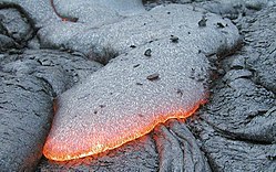 Lava basáltica
Clasificación de las coladas de lava
Las coladas de lava se clasifican principalmente en dos tipos según su morfología que presentan en superficie y que en gran medida depende de su composición y viscosidad:
- Pahoehoe
Las coladas pahoehoe son las que presentan una superfície de aspecto suave y vítreo, con estructuras cordadas muy características. Se forman en la erupción de magmas muy poco viscosos.
 Lava Pahoehoe
Las coladas aa tienen una superfície irregular, rugosa con bloques de tamaños decimétricos a métricos, de forma irregular y lados afilados.
 Lava Aa
Mareas
Las mareas son aumentos o caídas del nivel del mar de acuerdo a la combinación de las fuerzas gravitaciones de la Luna y el Sol con respecto a la rotación de nuestro planeta. Sin embargo, es la Luna la protagonista de las mareas.
La Luna es pequeña, pero está lo suficientemente cerca como para que su atracción gravitacional mueva cosas sobre la Tierra, y el movimiento de los océanos son parte de las cosas que sí podemos notar a simple vista gracias a su fluidez. A dicha atracción se le llama fuerza de marea. A medida que la Tierra gira, la gravedad lunar atrae las aguas de diferentes regiones terrestres.
La fuerza de marea hace que el agua de la Tierra se mueva y sobresalga del lado más cercano a la Luna y del lado más alejado también, aunque con menor fuerza. A ello se le denomina
marea alta o pleamar.
Mientras esto ocurre, el agua terrestre que no queda alineada con la Luna permanece en
marea baja o bajamar.
 Esquema mareas. Fuente: Ecología verde
A la diferencia de altura entre ambas, se le denomina
rango o amplitud de marea.
Durante el día hay dos mareas altas y dos mareas bajas. En internet hay varias páginas que te informan de cuando es pleamar y cuando bajamar.
Para resolver el earthcache tendréis que visitar la zona del Puertito. Leyendo el listing y visitando el lugar podréis responder a las preguntas de este earth. Recordad haceros la foto obligatoria.
PREGUNTAS
Para poder registrar como encontrado este earth, nos tenéis que mandar un correo (podéis hacerlo desde nuestro perfil de usuario) con las respuestas a las siguientes preguntas. Podéis loguear el earthcache sin haber recibido nuestra respuesta. Si no recibimos el correo con las respuestas correctas, el log podrá ser borrado sin previo aviso.
1.- Explica con tus palabras como crees que se ha formado geológicamente este lugar.
2.- ¿Por qué crees que el agua del océano en este punto tiene este color tan bonito?
3.- Observa los roques del puertito que hay en frente tuyo, mirando al océano. ¿Qué tipo de lava son, Pahoehoe o AA?
4.- FOTO. Hazte una fotografía desde el muelle de madera del Puertito (waypoint 1) con el océano al fondo (si no quieres salir, un papel con tu nick o tu GPS será válido). Recuerda que esta fotografía es OBLIGATORIA para demostrar que has visitado este earthcache.
5.1.- Situate en la playa situada a la izquierda del muelle de madera (waypoint 2) y dime que día es hoy, que hora es y cuantos metros hay desde donde estás hacia el agua (longitud de la playa)
5.2.- OPCIONAL: Si tienes tiempo te invito a que vuelvas más tarde y repitas la operación y me digas que hora es y la longitud de la playa. Verás que cambio!
Si no recibimos las respuestas, el log será borrado sin previo aviso.
También podrán ser borrados todos los logs que no incluyan la fotografía obligatoria de la pregunta 4 (desde la actualización de las guidelines de junio de 2019, la fotografía puede ser obligatoria para demostrar que se ha visitado el sitio).
No olvides que estás dentro de un entorno natural, hay que respetarlo y cuidarlo.
Gracias por vuestra comprensión y esperemos que disfrutéis del lugar.

ENGLISH VERSION
El Puertito de Lobos (ENG)
A few steps from the pier where you landed is the Puertito de Lobos, a paradisiacal place with charm on all sides. The best thing is the natural pool with transparent waters surrounded by basaltic rocks and full of fish that invites you to swim in it and snorkel.
We are on Isla de Lobos, an islet that emerged in the Pleistocene as a result of a basaltic fissure originating north of Fuerteventura that extended in a NE direction.
Basalt
Basalt is the most common variety of rock produced by magma. It is a volcanic igneous rock that is characterized by having a dark color, due to its high content of iron and magnesium. It consists mainly of metal oxides such as iron oxide, silicon oxide and magnesium, among others. Small phenocrysts may be present in its composition, although it also occurs in the form of crystals with no or very few visible crystals. It presents a high hardness (8 on the Mohs scale) and easy handling, in terms of its exploitation. Due to its physical-mechanical characteristics, it is an ideal material for construction, for exterior coverings and pavements, even those with intense traffic (paving stones, standard pieces, etc.). It is also used as a decorative element for its aesthetics and for being able to be treated in shape, cut, mold and color. Unusually, it is also used in spa treatments such as massages.
Lava
Lava is the magma that during its slow ascent through the earth's crust reaches the surface. Most lavas crystallize during the eruption, due to chemical imbalances induced in the magma as it approaches the surface. Its physical properties are highly conditioned by its composition, its content in volatiles, in crystals, or by its cooling history.
Basaltic lava
Classification of lava flows
Lava flows are mainly classified into two types according to their morphology that they present on the surface and which largely depends on their composition and viscosity:
- Pahoehoe
Pahoehoe flows are those that have a surface with a smooth and glassy appearance, with very characteristic cordate structures. They are formed in the eruption of very low viscous magmas.
Lava Pahoehoe
- Aa
Aa flows have an irregular, rough surface with blocks of decimeter to metric sizes, irregularly shaped, and sharp-edged.
Lava Aa
Tides
Tides are rises or falls in sea level according to the combination of the gravitational forces of the Moon and the Sun with respect to the rotation of our planet. However, the Moon is the protagonist of the tides.
The Moon is small, but it is close enough for its gravitational attraction to move things on Earth, and the movement of the oceans are some of the things that we can see with the naked eye thanks to its fluidity. This attraction is called tidal force. As the Earth rotates, lunar gravity pulls water from different regions of Earth.
The tidal force causes water on Earth to move and bulge on the side closest to the Moon and on the far side as well, although with less force. This is called
high tide or pleamar.
While this occurs, the terrestrial water that is not aligned with the Moon remains at
low tide or bajamar.
Tides scheme. Font: Ecología verde
The height difference between the two is called
the tidal range or amplitude.
During the day there are two high tides and two low tides. On the internet there are several pages that inform you when it is high tide and when it is low tide.
To solve the earthcache you will have to visit the Puertito zone. By reading the listing and visiting the place you will be able to answer the questions of this earth. Remember to take the obligatory photo.
QUESTIONS
Para poder registrar como encontrado este earth, nos tenéis que mandar un correo (podéis hacerlo desde nuestro perfil de usuario) con las respuestas a las siguientes preguntas. Podéis loguear el earthcache sin haber recibido nuestra respuesta. Si no recibimos el correo con las respuestas correctas, el log podrá ser borrado sin previo aviso.
1.- Explain in your own words how do you think this place was formed geologically.
2.- Why do you think the ocean water at this point has this beautiful color?
3.- Observe the rocks of the little port that is in front of you, looking at the ocean. What kind of lava are, Pahoehoe or AA?
4.- PHOTO. Take a picture of yourself from the wooden pier of the Puertito (waypoint 1) with the ocean in the background (if you don't want to appear, a piece of paper with your nickname or your GPS will be ok). Remember that this photograph is REQUIRED to prove that you have visited this earthcache.
5.1.- Stand on the beach located to the left of the wooden pier (waypoint 2) and tell me what day it is today, what time it is and how many meters there are from where you are towards the water (length of the beach)
5.2.- OPTIONAL: If you have time, I invite you to come back later and repeat the operation and tell me what time it is and the length of the beach. You'll see what a change!
If we don't receive the answers, the log will be deleted without prior notice.
All logs that do not include the required photograph in question 4 may also be deleted (since update of the guidelines in June 2019, the photograph may be required to prove that the place has been visited).
Don't forget you are in a natural environment, you have to respect it and take care of it.
Thank you for your understanding and we hope you enjoy the place.