

Introduction
Dans cette balade géologique, je vous propose de découvrir différemment la ville de Dunkerque et ses monuments. La première étape est le monument des fusiliers marins.
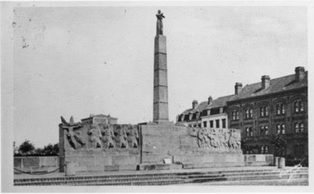
Ce monument est créé au 20ème siècle par le sculpteur Félix Desruelles; un spécialiste du monument commémoratif et du monument aux morts.
Il réalise ici une œuvre originale qui commémore la mémoire des marins français tombés au cours des combats terrestres pendant la Première Guerre mondiale.
Cette réalisation est d’après la littérature, le seul monument français dédié aux fusiliers-marins. Il présente des soldats en action emmenés par la Victoire inspirée de la frise du Parthénon, dans une version Art déco : utilisation d’un grès rose, symétrie de la mise en page accentuée par la statue de Jeanne d'Arc posée sur une colonne.
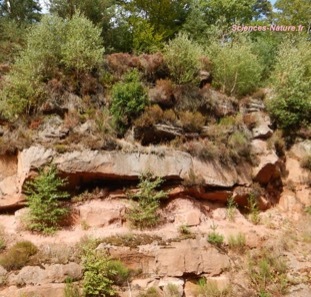
Le grès rose des Vosges utilisé dans ce monument est une roche plutôt rare sous nos latitudes. Dans cette Earthcache, nous allons nous attarder un peu sur ce grès qui date du début du Trias il y a 250 Ma.
Grès rose des Vosges
Le grès rose est une roche sédimentaire caractéristique des Vosges et de l’Alsace. Cette roche affleure sur de grandes surfaces qui participent à la structuration du paysage.
Au fait, c’est quoi du grès ?
Le grès est une roche sédimentaire qui est issue de l’agrégation et la cimentation de grains de sable qui eux proviennent du démantèlement d’un massif granitique. Il s'agit d'une roche cohérente et dure.
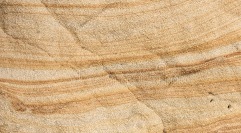
Le grès rose est formé par l'agglomération de grains constitués essentiellement de quartz (gris vitreux), et de feldspaths (orthoses roses et plagioclases blancs).
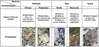
Dans la formation des Grès rose des Vosges, on peut voir un ensemble de grains de quartz millimétriques et quelques feldspaths cimentés par de la silice. Les oxydes de fer dispersés dans le ciment lui donnent cette teinte rose. On peut observer également quelques clastes (fragments) dans cette roche : ce sont de petits galets de différentes natures.
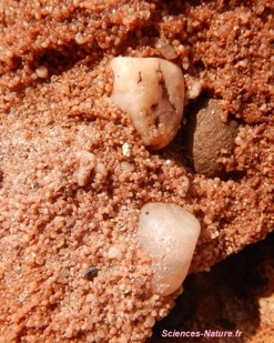
Zoom sur un grès. (Taille : 5 cm)
De quand date ce grès ? Comment s’est-il formé ?
Le sable à l’origine de ce grès provient de l’érosion des derniers reliefs de la chaîne Hercynienne (une chaîne de montagne aussi importante que l’Himalaya dont la formation a commencé il y a 360 millions d’années.)
Au début du Trias, il y a 250 millions d’années, les reliefs hercyniens se sont aplanis jusqu’à former une surface de vastes dimensions très faiblement ondulée appelée, pénéplaine.
Les produits de cette érosion vont s’accumuler dans une immense plaine deltaïque (aujourd’hui les Vosges et l’Alsaces), en bordure d’une mer qui s’étendait sur l’Allemagne.
Des rivières descendent des reliefs et déposent de grandes quantités de sables ainsi que des galets qui s’accumulent dans la multitude de bras de cet immense réseau deltaïque.
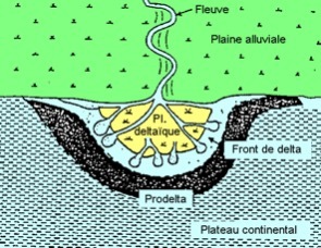
plaine deltaïque
Ces sables et galets vont être enfouis et recouverts par de nouveaux dépôts sédimentaires. Sous l’effet de la pression et de la chaleur, le phénomène de diagenèse a lieu : sables et galets vont peu à peu se compacter et se silicifier ensemble. Ce phénomène aboutit à la formation d’une roche sédimentaire : le grès.
Puis l’érosion et les mouvement tectoniques plus récents ont ramenés cette roche en surface; ce qui explique que l’on peut la voir aujourd’hui sur certains affleurements.
Une particularité du grès : Les bandes de Liesegang
Dans certaines roches, on peut observer des bandes colorées qui peuvent traverser les plans de litage. Elles ont une forme de coloration ferreuse produite par une série de réactions chimiques complexes dans les eaux souterraines percolant à travers la roche.
Bien que le processus exact de leur formation ne soit pas certain et qu’il soit toujours étudié par les géologues, il est généralement admis qu'elles ne se forment pas lors du dépôt initial des sédiments mais à un moment ultérieur. On les trouve le plus souvent dans les roches sédimentaires, mais on peut parfois trouver des caractéristiques similaires dans les roches ignées et métamorphiques.
Où trouver du grès en France ?
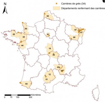
Les grès, qui représentent une petite part des volumes de roches extraits en France (3%), proviennent principalement des Vosges, où ils marquent fortement le patrimoine bâti. Leur texture est rugueuse et offre une palette de coloris allant du rouge au gris, en passant par le rose, le blanc, le jaune ou le bigarré.
La principale région d’exploitation des grès en France est celle des Vosges. Ils sont aussi localement extraits dans :
* le Massif armoricain,
* le Massif central,
* le Pays basque
* en Ile-de-France.
Les sources bibliographiques
- https://monumentsmorts.univ-lille.fr/monument/226/dunkerque-place
- https://sciences-nature.fr/gres-rose-vosges/
- https://www.snroc.fr/fr/gres_47.html
Pour valider la Earthcache
Pour pouvoir valider cette EarthCache, vous devrez répondre correctement aux questions suivantes et ajouter à votre log une photo de vous, de votre GPS ou de votre pseudo au waypoint de la cache. Cette photo permettra de valider le « trouvé » en cas de mauvaise réponse aux questions.
Merci d’envoyer vos réponses via mon profil ou via la messagerie geocaching.com, ne les donnez pas dans votre log. Les logs enregistrés sans réponses seront supprimés.
Vous pouvez loguer la cache "trouvé" sans attendre ma confirmation, je vous contacterai en cas de problème.
Rappel concernant les Earthcaches: Il n'y a pas de conteneur à rechercher ni de logbook à renseigner. Il suffit de se rendre sur les lieux, de répondre aux questions et de me renvoyer les réponses.
Question 1 : Comment s’appelle la roche utilisée pour ce monument et d’où provient-elle ?
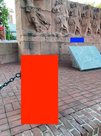
Question 2 : Observez la roche sous la zone bleu et décrivez ce que vous voyez. Comment s’appelle ce phénomène ?
Question 3 : Certaines zones du monument sont retouchées. Selon vous, quel est le matériau utilisé ?
Question 4 : Sous la zone rouge, des éléments dépassent de la roche. De quoi s’agit-il ? D’après vous, est-ce que ces éléments datent de la création de la roche ?

Introduction
In this geological walk, I propose you to discover differently the city of Dunkerque and its monuments. The first step is the monument of the marine fusiliers.
This monument was created in the 20th century by the sculptor Félix Desruelles, a specialist in memorials and war memorials.
He realized here an original work that commemorates the memory of the French sailors who fell during the land battles of the First World War.
According to the literature, this work is the only French monument dedicated to the fusiliers-marins. It presents soldiers in action led by the Victory inspired by the frieze of the Parthenon, in an Art Deco version: use of a pink sandstone, symmetry of the layout accentuated by the statue of Joan of Arc placed on a column.
The pink Vosges sandstone used in this monument is a rather rare rock in our latitudes. In this Earthcache, we are going to linger a little on this sandstone which dates from the beginning of the Triassic period, 250 Ma ago.
Pink Vosges sandstone
The pink sandstone is a sedimentary rock characteristic of the Vosges and Alsace. This rock outcrops on large surfaces which participate in the structuring of the landscape.
By the way, what is sandstone?
The sandstone is a sedimentary rock which is issued from the aggregation and the cementing of sand grains which come from the dismantling of a granitic massif. It is a coherent and hard rock.
The pink sandstone is formed by the agglomeration of grains consisting essentially of quartz (glassy gray), and feldspars (pink orthoses and white plagioclases).
In the formation of the pink sandstone of the Vosges, one can see a set of millimetric grains of quartz and some feldspars cemented by silica. The iron oxides dispersed in the cement give it this pink tint. One can also observe some clasts (fragments) in this rock: they are small pebbles of various natures.
How old is this sandstone? How was it formed?
The sandstone was formed by the erosion of the last reliefs of the Hercynian chain (a mountain chain as important as the Himalayas, whose formation started 360 million years ago).
At the beginning of the Triassic period, 250 million years ago, the Hercynian reliefs flattened out to form a vast, very slightly undulating surface called the peneplain.
The products of this erosion accumulated in a huge deltaic plain (today the Vosges and Alsace), bordering a sea that extended over Germany.
Rivers flow down from the relief and deposit large quantities of sand and pebbles which accumulate in the multitude of arms of this immense deltaic network.
These sands and pebbles will be buried and covered by new sedimentary deposits. Under the effect of pressure and heat, the phenomenon of diagenesis takes place: sands and pebbles will gradually compact and silicify together. This phenomenon leads to the formation of a sedimentary rock: sandstone.
Then erosion and more recent tectonic movements brought this rock back to the surface, which explains why it can be seen today on some outcrops.
A special feature of sandstone: The Liesegang bands
In some rocks, colored bands can be observed that can cross the bedding planes. They are a form of iron coloration produced by a series of complex chemical reactions in the groundwater percolating through the rock.
Although the exact process of their formation is not certain and is still being studied by geologists, it is generally accepted that they do not form during the initial deposition of the sediments but at a later time. They are most often found in sedimentary rocks, but similar features can sometimes be found in igneous and metamorphic rocks.
Where to find sandstone in France ?
Sandstone, which represents a small part of the volume of rock extracted in France (3%), comes mainly from the Vosges, where it has a strong impact on the built heritage. Their texture is rough and offers a palette of colors ranging from red to gray, through pink, white, yellow or variegated.
The main region of exploitation of sandstone in France is the Vosges. They are also extracted locally in :
* the Armorican Massif,
* the Massif Central,
* the Basque Country
* in the Ile-de-France region.
To validate this Earthcache
In order to validate this EarthCache, you will need to answer the following questions correctly and add a photo of yourself, your GPS or your nickname to your log at the cache waypoint. This photo will validate the "found" in case of wrong answers to the questions.
Please send your answers via my profile or via the geocaching.com messaging system, do not give them in your log. The logs recorded without answers will be deleted.
You can log the "found" cache without waiting for my confirmation, I will contact you in case of problem.
Reminder about Earthcaches: There is no container to look for or logbook to fill out. Just go to the location, answer the questions and send the answers back to me.
Question 1 : What is the name of the rock used for this monument and where does it come from?
Question 2 : Look at the rock under the blue area and describe what you see. What is this phenomenon called?
Question 3 : Some areas of the monument are retouched. In your opinion, what material was used?
Question 4 : Under the red zone, elements are protruding from the rock. What are they? According to you, do these elements date from the creation of the rock?