
La Earthcache / The Earthcache
Le Mont Saint Michel n'est pas seulement un lieu remarquable par sa valeur culturelle et patrimoniale, il est également un particularité géologique hors du commun.
Tel le sommet d'un iceberg semblant surgir au milieu d'un vaste baie faite de sédiments fluvio-marins recouvrant un socle de schistes briovériens , cet imposant piton est la partie émergée d'un inselberg, une "montagne île" faite d'une formation plutonique d'anatexie.
► La roche plutonique de l'Inselberg
Une roche plutonique est une formation grenue dont les cristaux sont visibles à l'œil nu.
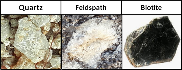
Cette roche se caractérise par une composition chimique principalement formée de 3 minéraux QFM :
- Q comme Quartz : translucide parfois transparent, ce minéral est gris sans facette.
- F comme Feldspath : ce minéral opaque est blanc ou rose selon la présence d’oxydes de fer.
- M comme Mica noir (biotite) : minéral ferro-magnésien noir brillant.
La proportion de ces minéraux détermine la teinte d'une roche magmatique et couplée avec sa texture grenue la caractérise selon le Diagramme de Streckeisen :
- une roche hololeucocrate est blanche, elle possède moins de 12,5% de ferromagnésiens.
- une roche leucocrate possède entre 12,5 et 37,5% de ferromagnésiens.
- une roche mésocrate possède entre 37,5 et 62,5% de ferromagnésiens.
- une roche est mélanocrate possède plus de 62,5% de ferromagnésiens.
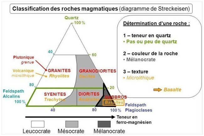
La teinte dépend donc directement de la teneur en cristaux ferromagnésiens, ici la biotite.
► A l'origine était un pluton d'anatexie
Le massif plutonique du Mont Saint Michel est une formation anatectique, fruit de la fusion d'un protolithe lors d'une évènement tectonique puis de la recristallisation du magma.
Il est le témoin de la fin de l'orogenèse cadomienne (-225 Ma) quand la bordure Nord du paléocontinent Gondwana subissait une collision avec un arc insulaire.
C'est un petit massif de quelques kilomètres avec un magma de basse température formée par la fusion en présence d'eau des roches du socle briovérien.
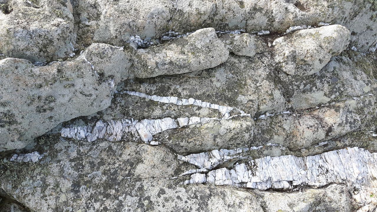
► Et souvent à la fin ça rompt... pour donner des filons !
Une poche de magma plutonique refroidit lentement dans les profondeurs de la croûte terrestre, donnant ce caractère grenue à la roche (les cristaux ont le temps de se former).
Vers la fin de sa cristallisation, bien qu'encore liquide par endroits, la roche est déjà peu ductile et se casse quand elle est soumises à des pression, donnant de nombreuses fissures.
Le reste de la phase liquide (jus résiduels claires riches en silice) va s'introduire dans ces fractures et cristalliser très lentement, donnant de très gros cristaux (centimétriques à métriques) portant le nom de pegmatite.
Occupant ces fractures, la pegmatite forme des filons de phénocristaux opaques de couleur blanc.
► Dureté des roches, érosion différentielle... Et le Mont fût !
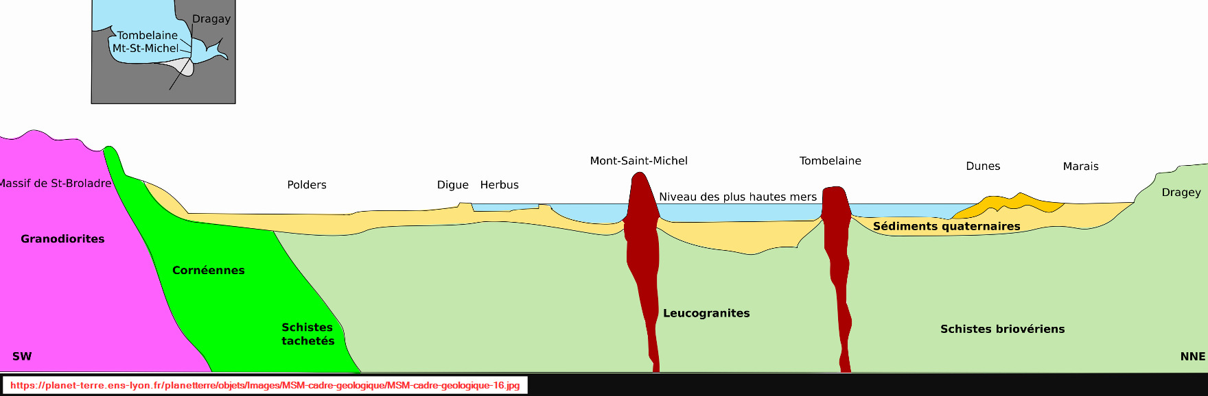
Mis en place au coeur du socle de schistes briovériens, les plutons granitiques ont peu à peu remonté à la surface (ou plutôt la surface est venue à eux) par la magie de l'érosion du socle.
Une fois en surface au même niveau que l'encaissant schisteux, un mécanisme d'érosion différentielle s'est mis en place entre les deux ensembles.
On parle d'érosion différentielle entre deux formations de dureté et résistance différente : la plus tendre des deux voit son niveau baisser plus rapidement par l'érosion, formant par contraste la mise en relief de la formation la plus résistante sous la forme d'un pointement rocheux.
Dans la région de la baie, ce sont 3 pointement rocheux, les fameux inselberg, qui ont ainsi par contraste "émergé" : le Mont-Saint-Michel, Tombelaine et le Mont-Dol.
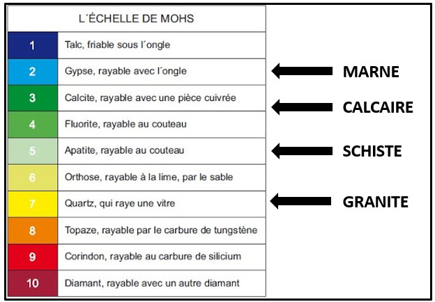
Le potentiel d'une érosion différentielle s'illustre en évaluant la dureté des roches grâce à l'échelle de Mohs, échelle ordinale avec laquelle on procède par comparaison (capacité de l'un à rayer l'autre).
Mont Saint Michel is not only a place remarkable for its cultural and heritage value, it is also an extraordinary geological feature.
Like the top of an iceberg seeming to rise in the middle of a vast bay made of fluvio-marine sediments covering a base of Brioverian shales, this imposing peak is the emerged part of an inselberg, an "island mountain" made of a plutonic formation of anatexia.
► The plutonic rock of the Inselberg
A plutonic rock is a grainy formation whose crystals are visible to the naked eye.
This rock is characterized by a chemical composition mainly formed of 3 QFM minerals:
- Q for Quartz: translucent sometimes transparent, this mineral is gray without facets.
- F for Feldspar: this opaque mineral is white or pink depending on the presence of iron oxides.
- M for Black Mica (biotite): shiny black ferromagnesian mineral.
The proportion of these minerals determines the hue of an igneous rock and coupled with its grainy texture characterizes it according to the Streckeisen diagram:
- a hololeucocratic rock is white, it has less than 12.5% ferromagnesians.
- a leucocratic rock has between 12.5 and 37.5% ferromagnesians.
- a mesocratic rock has between 37.5 and 62.5% ferromagnesians.
- a rock is melanocratic has more than 62.5% ferromagnesians.
The color therefore depends directly on the content of ferromagnesian crystals, here biotite.
► Originally was a pluton of anatexia
The plutonic massif of Mont Saint Michel is an anatectic formation, the result of the fusion of a protolith during a tectonic event and then the recrystallization of magma.
It bears witness to the end of the Cadomian orogeny (-225 Ma) when the northern edge of the Gondwana paleocontinent suffered a collision with an island arc.
It is a small massif of a few kilometers with a low temperature magma formed by the fusion in the presence of water of the rocks of the Brioverian basement.
► And often in the end it breaks... to give veins!
A pocket of plutonic magma cools slowly in the depths of the earth's crust, giving this grainy character to the rock (the crystals have time to form).
Towards the end of its crystallization, although still liquid in places, the rock is already not very ductile and breaks when it is subjected to pressure, giving many cracks.
The rest of the liquid phase (residual clear juices rich in silica) will be introduced into these fractures and crystallize very slowly, giving very large crystals (centimetric to metric) bearing the name of pegmatite.
Occupying these fractures, the pegmatite forms veins of opaque white phenocrysts.
► Hardness of the rocks, differential erosion... And the Mont was!
Placed in the heart of the basement of Brioverian schists, the granitic plutons gradually rose to the surface (or rather the surface came to them) by the magic of the erosion of the basement.
Once on the surface at the same level as the schist rock, a differential erosion mechanism is set up between the two sets.
We speak of differential erosion between two formations of different hardness and resistance: the softer of the two sees its level drop more quickly by erosion, forming by contrast the highlighting of the most resistant formation in the form of a rocky point.
In the region of the bay, there are 3 rocky points, the famous inselbergs, which have thus "emerged" by contrast: Mont-Saint-Michel, Tombelaine and Mont-Dol.
The potential for differential erosion is illustrated by evaluating the hardness of rocks using the Mohs scale, an ordinal scale with which we proceed by comparison (ability of one to scratch the other).
► Sources bibliographiques / Bibliographical sources
Les Questions / The Questions
La lecture attentive du descriptif de la cache, ainsi qu'une observation des éléments de terrain et un peu de déduction sont normalement suffisants pour répondre aux questions de cette EarthCache.
A careful reading of the description of the cache, as well as observation of terrain features and some deduction is usually sufficient to answer questions of this EarthCache.
Questions pour valider :"L'Inselberg du Mont Saint Michel"
Questions to validate: "The Inselberg of Mont Saint Michel"
- Question 0 : Prenez une photo de vous ou d'un élément avec la Baie du Mont Saint Michel ou le sommet du Mont en arrière plan.
Cette photo devra au choix nous être transmise avec les réponses ou être ajoutée à votre log.
- Question 0 : - Question 0: Take a picture of yourself or of an element with the Bay of Mont Saint Michel or the summit of the Mont in the background.
This photo must either be sent to us with the answers or added to your log.
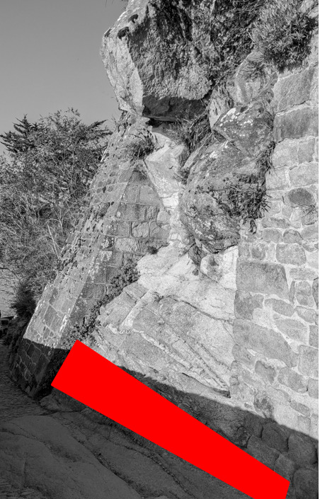
Vous voici sur le chemin de ronde de l'Abbatial, devant un vaste affleurement de roche de l'Inselberg visible entre deux éléments de la muraille (photo WP1).
Here you are on the Abbatial walkway, in front of a vast outcrop of Inselberg rock visible between two elements of the wall (photo WP1).
- Question 1 : Qualifiez la couleur et la texture de la roche saine (voir les classifications du descriptif). Quel minéral semble faire le plus défaut ?
- Question 1 : Qualify the color and the texture of the sound rock (see the classifications of the description). Which mineral seems to be most lacking?
- Question 2 : A l'aide du diagramme de Streckeisen, déduisez en la nature de la roche de l'Inselberg.
- Question 2 : Using the Streckeisen diagram, deduce the nature of the Inselberg rock.
- Question 3 : Décrivez ce vous voyez sous la zone rouge. Quelle est le nom et la composition minérale de ces structures et comment se sont-elles mises en place ?
- Question 3 : Describe what you see under the red area. What is the name and mineral composition of these structures and how did they come about?
- Question 4 : A l'aide d'une lame de métal voire d'un morceau de verre, essayez de rayer la roche et déduisez en sa dureté sur l'échelle de Mohs. En utilisant vos déductions et le descriptif, expliquez pourquoi vous pouvez aujourd'hui admirer une magnifique vue depuis les hauteurs de cet Inselberg.
- Question 4 : Using a metal blade or even a piece of glass, try to scratch the rock and deduce its hardness on the Mohs scale. Using your deductions and the description, explain why you can now admire a magnificent view from the heights of this Inselberg.
Vous pouvez vous loguer sans attendre notre confirmation,
mais vous devez nous envoyer les réponses en même temps soit par mail via notre profil (
fafahakkai), soit via la messagerie geocaching.com (Message Center).
S'il y a des problèmes avec vos réponses nous vous en ferons part.
Les logs enregistrés sans réponses seront supprimés.You can log this cache without waiting for our confirmation, but you must send us the answers at the same time, by e-mail via our profile (fafahakkai) or by the system of Message Center of geocaching.com.
If there is a problem with your answers we will notify you. The logs recorded without answers will be deleted.
Rappel concernant les « Earthcaches »: Il n'y a pas de conteneur à rechercher ni de logbook à renseigner. Il suffit de se rendre sur les lieux, de répondre aux questions ci-dessus et de nous renvoyer les réponses.
Reminder concerning "Earthcaches": there is neither a container to look for nor a logbook to sign. One need only go to the location, answer to the differents questions and send us the answers.