Flint
A Brief Overview of the Geology of Bahrain
Much
of the Bahrain Peninsula is covered by extensive
sedimentary formations dating from the Eocene (Cenozoic) to the present
day. The present rock strata show that the Eocene in Bahrain was
characterized by shallow sea conditions. Apart from the anticline,
Bahrain has few tectonic compression features, which means
stratgraphically that the layers are mostly as they were originally
deposited.
Most rocks that outcrop on the surface on Bahrain
Peninsula date to the Eocene in the Cenozoic. The rimrock of Eocene
limestone forms a ring around the main peninsula, with cliffs up to
30,5 meters tall and wind erosion features are common. An angular
unconformity separates middle Eocene rocks from sandier Miocene rocks.
The Rus Formation is encompassing the Ad Dammam area in Saudi Arabia
and
is exposed in central Bahrain as limestone with chert and chalk layers
along with quartz geodes. Limestone from the formation is widely used
for concrete production.
The Shark Tooth Shale of the Dammam Formation from the middle Eocene
overlies the Rus Formation with gray-yellow shale, marl, and dolomite.
The lowest clay-shale bed contains shark teeth fossils, giving the unit
its name. A brown crystalline dolomite limestone layer, correlated with
the Khobar Member in Saudi Arabia sits at top of the Sharks Tooth Shale
capped by an impervious orange marl unit that separates two zones of
aquifers, Zone A and Zone B. The white limestone of Zone A ranges
widely in thickness from a few meters up to more than 60 meters. This
unit is a major source of fresh water for Bahrain.
Miocene rocks include clay, marl, shale and sandy limestone in the
flank of the Bahrain anticline. Recent Quarternary beach sands and salt
marshes dominate large areas of the peninsula. Anhydrite indicates that
the Eocene was marked by shallow marine conditions. Bahrain has few
compressional tectonic features aside from the anticline. Uplift and
regional tilting spurred erosion, resulting in the missing of late
Eocene and Oligocene sediments.
The area in the range of the Earthcache coordinates shows typical
Eocene strata, with the stratum containing the flints being a white,
chalky limestone.
Flint
Flint, occasionally flintstone, is a siliceous rock and
consists almost exclusively of silicium dioxide (SiO2), the mineral
quartz. The term "flint" is preferably used to describe rock formations
that have arisen through compaction and transformation processes in
fine-grained marine limestone or chalk. Presumably, solutions
containing silicic acid cause carbonates to be displaced during rock
formation. Flint deposits are found in numerous Jurassic and
Cretaceous, but also in Eocenic deposits.
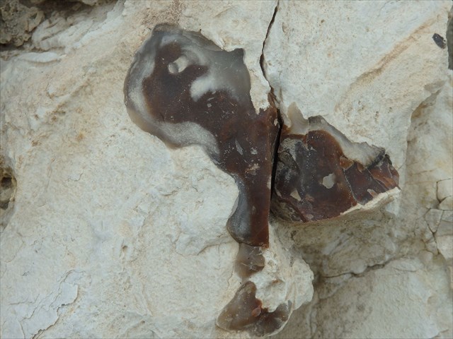
Flint occurs chiefly as nodules and masses in sedimentary rocks,
usually the nodules are embedded in chalk deposits. Inside the nodule,
flint is usually dark grey, black, green, white or brown in colour. It
often has a glassy or waxy appearance. A thin layer on the outside of
the nodules is usually different in colour, typically white and rough
in texture. The German name "Feuerstein" refers to the flint's
historical importance for making fire. When struck against steel, flint
will produce enough sparks to ignite a fire with the correct tinder, or
gunpowder used in weapons.
Flint breaks and chips into sharp-edged pieces, making it useful for
knife blades and other cutting tools. The use of flint to make stone
tools dates back hundreds of thousands of years, it is one of the
primary materials used to define the Stone Age.
The exact mode of formation of flint is not yet clear, but it is
thought that it occurs as a result of chemical changes in compressed
sedimentary rock formations during the process of diagenesis.
Diagenesis is the process by which sediments evolve after they are
deposited and begin to be buried, which can include physical effects
such as compaction, as well as chemical reactions. Diagenesis refers to
all of the chemical, physical and biological changes undergone by
sediment after initial deposition.
One hypothesis is that a gelatinous material fills cavities in the
sediment, maybe boreholes from crustaceans or molluscs, and that this
becomes silicified. This hypothesis would certainly explain the complex
shapes of flint nodules. The source of the dissolved silica in the
porous media could be the spicules of silicious sponges. Even pieces of
coral and vegetation have been found preserved inside certain
types of flint similar to insects and plant fragments within amber.
Your task to log the
cache:
Answer the following questions via message (not mail!) in English or
German via my geocaching profile:
1.) Describe the local flints in your own words (size, shape, colors
found here...)!
2.) Take a closer look at the broken edge of a flint - how would you
describe it?
3.) What do you think is harder or more weather resistant - the flints
or the surrounding rock? Explain your opinion!
4.) Optional: Post a photo with your log, showing you and/or your GPS
near the location!
After you've sent me the message
with your answers, feel free to log! Only if there's something wrong,
I'll contact you via message!
Sources:
Abbahussein, A. (2015): The Mineralogy, Geochemistry and Sedimentation
of the Shark Tooth Shale Member, Bahrain.
Bartholomäus, W.A. & E.-R. Look: Gerölle an
der Basis des
marinen Mitteleozäns von Helmstedt - mit einem Beitrag zur
Geröllführung des marinen Alttertiärs in
Norddeutschland. In: Ber. Naturhist. Ges. Hannover 138, S. 163 - 183
(Hannover 1996).
Press, F. & R. Siever (1995): Allgemeine Geologie.
Weilermars, R. (1999): Surface Geology, Lithostratigraphy and Tertiary
Growth of the Dammam Dome, Saudi Arabia: A New Field Guide.
wikipedia.org
Willis, R. P. (1963): Geology of the Arabian Peninsula: Bahrain.
www.Kalkmuseum.de
www.steine-scherben.de
The pictures were taken by the author.
Enjoy the location!
 The
most exciting way to learn about the Earth and its processes is to get
into the outdoors and experience it first-hand. Visiting an Earthcache
is a great outdoor activity the whole family can enjoy. An Earthcache
is a special place that people can visit to learn about a unique
geoscience feature or aspect of our Earth. Earthcaches include a set of
educational notes and the details about where to find the location
(latitude and longitude). Visitors to Earthcaches can see how our
planet has been shaped by geological processes, how we manage the
resources and how scientists gather evidence to learn about the Earth.
To find out more click HERE.
The
most exciting way to learn about the Earth and its processes is to get
into the outdoors and experience it first-hand. Visiting an Earthcache
is a great outdoor activity the whole family can enjoy. An Earthcache
is a special place that people can visit to learn about a unique
geoscience feature or aspect of our Earth. Earthcaches include a set of
educational notes and the details about where to find the location
(latitude and longitude). Visitors to Earthcaches can see how our
planet has been shaped by geological processes, how we manage the
resources and how scientists gather evidence to learn about the Earth.
To find out more click HERE.