Most of New Zealand’s early colonial settlements were built on or near the coast. European settlers, like Maori before them, relied on sea and river transport to link their isolated communities. Overland travel was often extremely difficult, especially in heavily forested, swampy or mountainous areas.
Many colonists, familiar with Britain’s extensive rail network, saw steam railway as a solution, promising progress and prosperity to the colony.
The South Island main trunk railway line was fairly easy to build following the comparatively flat eastern plains and was completed in the late 1870s between Christchurch and Dunedin and then through to Invercargill. The section from Christchurch north to Picton wasn't completed until after the second World war.
A main trunk railway between Auckland and Wellington was initially proposed in the 1860s. Construction commenced in Auckland and reached Te Awamutu by 1880. Construction of the Wellington end did not commence until 1885 reaching Palmerston North by 1886.
Further progress was blocked by rugged mountains, dense forests and the Māori stronghold of Te Rohe Pōtae (the King Country) who did not want to sell the land to let the train line through. Māori were experiencing increasing loss of land ownership. Pressure from European settlement for land and dodgy dealings were happening. The land wars and land confiscation were in recent memory.
Construction of the final central section began on 15 April 1885, when paramount chief Wahanui of Ngāti Maniapoto ceremonially ‘turned the first sod’ of the central section by the Pūniu River, near Te Awamutu.
It was another two decades before the two lines met as the crossing of the Volcanic Plateau with its deep ravines required huge viaducts (such as GC71YYC The Mighty Makatote geocache), but the steep climb up to the Waimarino plateau was still a major problem.
Eventually the line had reached Waimarino (National Park), on the south side, and to Raurimu Station on the north side. Although only around 7 kilometres separated the two stations, the height difference of 220 metres was too steep for trains to climb – the problem was to join up the two places with a workable grade through the bush covered rugged terrain. The area was thoroughly surveyed during the 1880s in an attempt to find a route with a suitable gradient but the only viable possibility seemed to require a 20-kilometre detour and nine massive viaducts. Even then, the gradient would have been very difficult.
The problem was solved in 1898 by surveyor Robert Holmes, Public Works Department engineer. He proposed a line that looped back upon itself and then spiralled around with the aid of tunnels and bridges, rising at a gradient of 1 in 52. Though costly and labour-intensive, the scheme was still cheaper than the detour route with its nine viaducts. The most remarkable feature is that even today there is no place to view the complete line. Apparently Holmes visualised the layout in his imagination.
The railway forms an ascending spiral southwards, with two relatively short tunnels, a circle and three hairpin bends. From the north, trains pass Raurimu before going round a 200° bend to the left in a horseshoe curve, climbing above the track on which they have just travelled. Two sharp bends to the right follow, after which the line passes through two short tunnels, the Lower Spiral Tunnel (384 m) and the Upper Spiral Tunnel (96 m). Trains then complete a full circle, crossing over the Lower Spiral Tunnel through which they have just passed which is 23-metre below, before continuing towards Wellington.
The Raurimu Spiral was completed in 1907 and the NIMT was formally opened on 6 November 1908, when Prime Minister Sir Joseph Ward drove home the final spike at Manganuioteao. Visit GC1MTBF Last Spike. It is a notable feat of civil engineering, having been called an "engineering masterpiece." The Institute of Professional Engineers of New Zealand has designated the spiral as a significant engineering heritage site. The most remarkable feature is that even today there is no place to view the complete line. Apparently Holmes visualised the layout in his imagination.
The completion of the NIMT was a major landmark in New Zealand’s history. It fostered economic and population growth in the North Island, opening up Pākehā access to the Māori-dominated interior, and accelerating the destruction of the great forests that once covered much of the island. For most New Zealanders, at the time, the NIMT was a proud symbol of progress, ushering in a golden age of rail transport in the first half of the 20th century.
Points of interest concerning this geocache
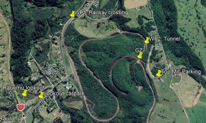
- From State Highway 4 turn into Raurimu Road. On the left is the Raurimu Spiral Lookout Amenity Area. Take a walk on the well graded all-weather track to the lookout and model of the Spiral. Dogs are allowed on leash.
Geocache GCMHTW Round N Round is located at the lookout
- Continue driving up Raurimu Road and cross the railway lines with care. The altitude here is approximately 591m ASL
- Continue up Raurimu Road and turn right into Top Mill Road. Follow the road to the 'end'. There's a great view of Mount Ruapehu from here.
You can park here, but please don't obstruct the farmer's driveway or continuation of the road. You can drive on, but it's a gravel road and quite steep. It's a 300m walk to GZ.
- There is room to park and turn around at GZ. You do not need to cross the railway line here, and I wouldn't recommend it.
The ‘lock & lock’ box geocache is behind the white plastic marker post.
- The altitude here is approximately 651m ASL. Check the distance to Waypoint 1
It is interesting to work out the gradient from WP1 to this point using the formula...
Gradient = Run (the distance)
Rise (the altitude change)
Gradient is expressed as 1:Gradient
The railway line has travelled 4.4 km through the spiral to reach this point. What gradient is the actual rail track?
- That is what makes the Raurimu Spiral so special. For added interest, go 200m down the road towards the large cutting to see the entrance to the Lower Spiral Tunnel. Again, do not go near the railway tracks.
References: Te Ara - The Encyclopedia of New Zealand, Story: Railways page 2: Main trunk lines https://teara.govt.nz/en/railways/page-2 (Accessed 8 Nov 2020)
Wikipedia contributors. (2020, October 13). Wikipedia, The Free Encyclopedia: North Island Main Trunk. https://en.wikipedia.org/wiki/North_Island_Main_Trunk (Accessed 8 Nov 2020)
Wikipedia contributors. (2020, November 7). Wikipedia, The Free Encyclopedia: Raurimu Spiral. https://en.wikipedia.org/wiki/Raurimu Spiral (Accessed 8 Nov 2020)