
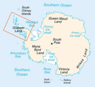
The landforms surrounding Orne Harbor are part of the Arctowski Peninsula, which itself is part of the Graham Land section of the Antarctic Peninsula.
Most of the rocks seen along the coast of Graham Land are the products of a linear belt of extinct volcanoes that ran approximately along the current coastal mountains of the peninsula. These volcanoes were part of the famous "ring of fire ." Volcanic activity started 183 million years ago in the Jurassic period when Gondwana, the original supercontinent, was breaking up, and Antarctica was beginning to separate from other southern continents. These first Jurassic volcanic rocks mainly occupy the eastern side of Graham Land.
Volcanism then migrated to the west coast of Graham land, where Orne Harbor is. Most of the volcanic rocks on that side of Graham Land date from the Cretaceous and Cenozoic times, from about 146 million years ago to our times.
The volcanic rocks can often be identified from afar because they have formed dark gray or brown cliffs or bluffs with traces of banding. The layering results from the succession of volcanic lava flows and periods of ash accumulation. Some volcanic rocks are hard and resistant to weathering, forming near-vertical cliffs. Later faults have titled some of these rocks. In some cases, one can observe black vertical pipes, called dykes, the leftovers of old channels that brought molten magma to the surface.
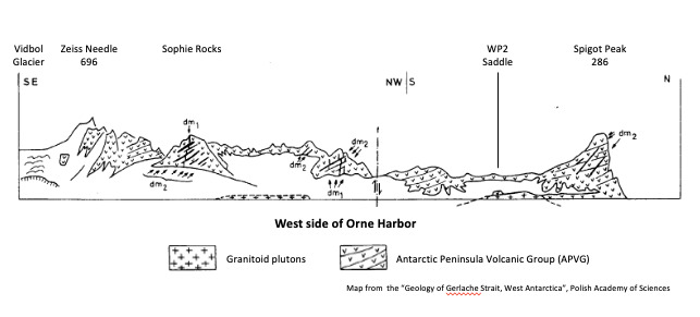
On the western side of Orne Harbor, between the conspicuous Spigot Peak at the harbor's entrance and Zeiss needle on the edge of the Vidbol glacier, most exposed rocks are part of the "Antarctic Peninsula Volcanic Group" (APVG). They are from the Lower Cretaceous and consist of altered basalt, basaltic andesite, and andesite lavas.
Definition: Basalt
Basalt is a fine-grained extrusive igneous (magmatic) rock formed from the rapid cooling of low-viscosity lava rich in magnesium and iron exposed at or very near the surface. More than 90% of all volcanic rock on Earth is basalt. Basalt is usually dark gray to black due to its high content of augite or other dark-colored pyroxene minerals.
Definition: Andesite
Andesite is a fine-grained extrusive igneous (magmatic) rock that is intermediate in its silica content and low in alkali metals. Andesite is usually light to dark gray due to its hornblende or pyroxene minerals content. The name Andesite is derived from the Andes mountain range, where it is found in abundance.
To complete this earthcache, you must physically visit Orne Harbor, including climbing to the saddle to observe the rocks up close. You need to send me by message the answer to the three questions within ten days of posting your log. You must include your picture in the log. The first two questions can be answered from the boat (Original Coordinates), and the third question needs to be answered from the saddle (WP2).
Question 1: To what group belong the rocks exposed at the top of the mountains between Spigot Peak and Zeiss needle?
Question 2: When looking at Spigot Peak from your boat, describe the orientation of the layers on the rocks. What do you think is the cause?
Question 3: At WP2, the observation point on the saddle, please describe the rocks you observe on the south side of the path crossing the saddle. What color are they? Can you see layers? If so, can you estimate the average height of a layer? Are they coarse-grained or fine-grained? Based on the definitions above, would you say they are basalts or andesites?
Requirement 4: Post a picture of yourself or your GPS with Spigot Peak in the background, either from the boat or the saddle.
Enjoy your visit at the fantastic Orne Harbor!
References:
- The Tectonic Structure Of Gerlache Strait, West Antarctica - Krzysztof Birkenmajer - Polish Polar Studies, Institute of Geological Sciences, Polish Academy of Sciences - June 1999
- Antarctic Peninsula: A Visitor's Guide, British Antarctic Survey, 2013
- Glossary, USGS: https://volcanoes.usgs.gov/vsc/glossary/
- Geology of Gerlache Strait, West Antarctica - Krzysztof Birkenmajer - Institute of Geological Sciences, Polish Academy of Sciences, 1995
- Sophie Rocks, Wikipedia: https://en.wikipedia.org/wiki/Sophie_Rocks