To
log this earthcache, send me an email with the answer
to the following questions:
1. Explain
very briefly what is necessary for an aquifer to
exist from a geological point of view. What two
types of rocks form the geological unit that forms
this aquifer?
2. Classify this aquifer
according to the 4 characteristics indicated in the
listing
3. How many water outlets can you
see in the "pool"?
4. Add a photograph of you in the
premises, or another in which you can see an object,
or your nick on a piece of paper
If you believe you have successfully completed this
Earth Cache goals and has already sent to me all the
requirements as requested, Please, feel free to log
it as found. Later i will verify the requirements
sent and, if necessary, contact you in order to make
the necessary corrections to your log.
|
|
Location
In the town of Cella, close to the Teruel capital, we can
find one of the most surprising hydrological phenomena in Aragon.
The water that emerges at the source comes from an artesian well,
whose aquifer transports the water collected from kilometers away.
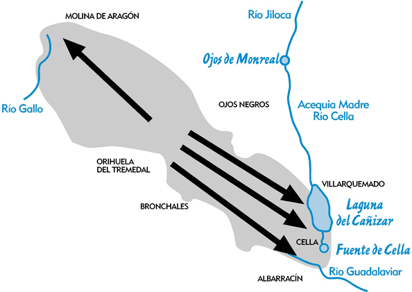
It feeds on rainfall that falls on an area of 1,350 km2 between
Cella and Molina de Aragón, and between Ojos Negros and Orihuela
del Tremedal. The rainwater and snow collected in this entire area
emerge at four points: the Gallo river upstream of Molina de
Aragón, the Guadalaviar river downstream of Albarracín, the
Cañizar lagoon and the Cella spring. It enters the porous earth
that covers this area, penetrating several hundred meters deep.
Despite the abundant rainfall on the surface, the ravines have
little development due to the rapid disappearance of water, and
the vegetation on the surface is typical of more arid areas. In
the infiltration zone, the formation of sinkholes (large
depressions) also stands out, since the water causes the
dissolution of the limestone, making hundreds of tons of dissolved
rock disappear every year due to the effect of the water.
The Cella Fountain has an elliptical shape with a greater diameter
of 34.83 meters and a smaller diameter of 24.84 meters. The
perimeter is 130 meters and is surrounded by a parapet of ashlar
stone, at one end the water exits through a passage covered by a
hermitage, dedicated to San Clemente. The depth is 9 meters on the
shore and 11.5 meters in the center and the average flow from this
well is about 3,500 liters per second.
The source is the origin of three ditches that irrigate 7 towns.
The irrigation ditches are the “Acequia Madre”, the “Acequia del
Caudo” and the “Acequia de la Granja”. The towns that take
advantage of these waters for irrigation are Cella, Villarquemado,
Santa Eulalia, Torremocha, Torrelacarcel, Alba and Villafranca.
Irrigation is scrupulously regulated by the "Royal Ordinances and
Providences of 1772".
Aquifers
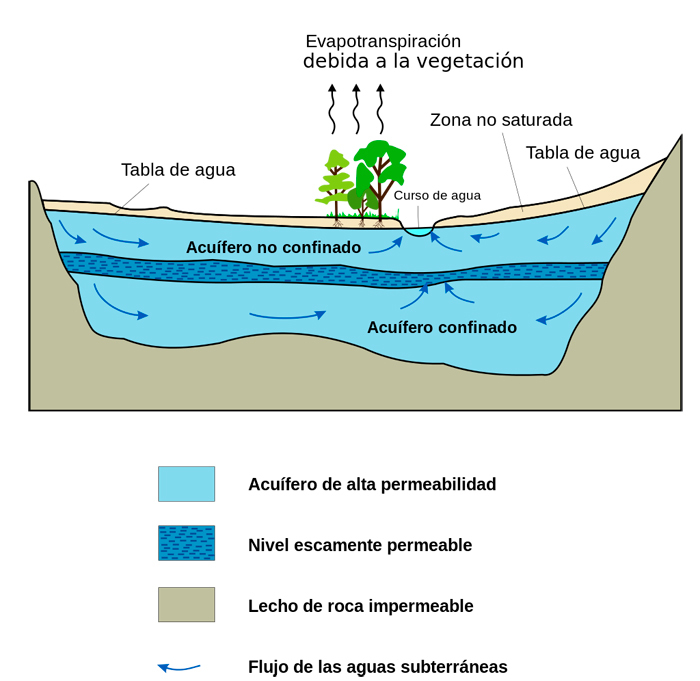
An aquifer is defined as a geological formation that is made up of
one or more layers of rocks, capable of storing and releasing
water. It is located in the soil in the area called "saturated
zone". Aquifers are characterized by having a certain permeability
and porosity, which are parameters that define the hydraulic
characteristics of the aquifer, that is, the movement of water
depends on the type of soil rocks.
Aquifers are formed thanks to rainwater that infiltrates into the
ground until it reaches impermeable strata that prevents the
passage of water and deposits between the underground rocks. The
rainwater that infiltrates into the ground allows the porous rocks
of the aquifers to be recharged with water.
Types of aquifers
Aquifers can be classified in several ways depending on the
criteria used:
Lithological characteristics: detrital and carbonate.
Type of holes: porous, karstic and/or fissured.
Hydrostatic pressure: free or unconfined (in contact with air and
separated by the unsaturated zone), confined or captive (subjected
to a pressure higher than atmospheric and in a fully saturated
zone) and semi-confined (some confined layers are semi-permeable).
Extension: local or specific aquifers (small extension) and
regional aquifers (very extensive)
Cella-Molina
de Aragon aquifer
The origin of the water that flows from the Fuente de Cella is
framed within the context of a large hydrogeological unit called
"Cella-Molina de Aragón". Simplifying the complex structure of
this great unit, it can be stated that it is a large aquifer
formed by Jurassic limestone, which presents high permeability due
to fissuring and karstification. The impermeable substrate is made
up of clays and gypsum from the Lower Triassic.
Making an analogy that facilitates its understanding, this
hydrogeological unit can be considered as a large sponge with a
water surface of 1350 km2 that extends from Cella to the
Southeast, to Molina de Aragón to the Northwest.
|