North Cape Reef EarthCache
-
Difficulty:
-

-
Terrain:
-

Size:  (other)
Please note Use of geocaching.com services is subject to the terms and conditions
in our disclaimer.
North Cape Reef
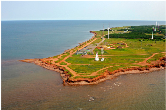
North Cape is a cape at the northwestern most extremity of Prince Edward Island. During the summer, Irish moss seaweed is commercially harvested from the shores around North Cape and surrounding areas. The Black Marsh Nature Trail, which is a 5.5 kilometer trail that is open to the public, focuses on the fauna and flora of the area.

North Cape Reef
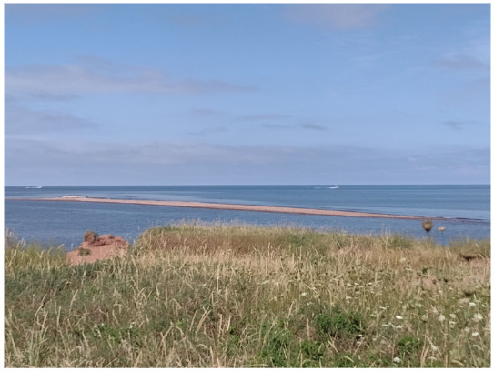
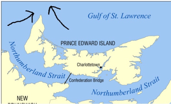
North Cape is the dividing point for delineating the western limits of the Northumberland Strait from the Gulf of St. Lawrence, as determined by the Canadian Hydrographic Service. A 2 km (1.2 mi) natural rock reef extends offshore from the cape. It is reportedly the longest natural rock reef composed of sedimentary rock in North America. You can walk out onto the reef at low tide, exploring the tidal pools, watching the gulls and enjoying the seals relaxing in the sheltered waters.

The meeting of the tides is really interesting to see. Prince Edward Island is encompassed on either side by the Northumberland Strait on the south and the Gulf of St. Lawrence on the north. Both of these bodies of water are moved by currents, including currents that come from the Atlantic Ocean into the Gulf of St. Lawrence. When these two tides meet at both North Cape and East Point, they create the effect called the "meeting of the tides". When you stand at either North Cape and East Point you can see that there is a thin line of waves created where the two tides collide, especially if you are there at high tide.

Geomorphology
The Gulf of St. Lawrence is the outlet of the North American Great Lakes via the St. Lawrence River into the Atlantic Ocean. The gulf is a semi-enclosed sea, covering an area of about 226,000 square kilometres (87,000 sq mi) and containing about 34,500 cubic kilometres (8,300 cu mi) of water, at an average depth of 152 metres (500 ft). Half of the ten provinces of Canada adjoin the Gulf: New Brunswick, Nova Scotia, Prince Edward Island, Newfoundland and Labrador, and Quebec.
The Laurentian Channel is a feature of the floor of the Gulf that was formed during previous ice ages, when the Continental Shelf was eroded by the Saint Lawrence River during the periods when the sea level plunged. The Laurentian Channel is about 290 m (950 ft) deep and about 1,250 km (780 mi) long from the Continental Shelf to the mouth of the Saint Lawrence River. Deep waters with temperatures between 2 and 6.5 °C (36 and 44 °F) enter the Gulf at the continental slope and are slowly advected (current movement) up the channel by estuariane circulation.

Northumberland Strait is formed by Prince Edward Island and the gulf’s eastern, southern and western shores. It has a depth of between 17 and 65 meters with the deepest waters at either end. The tidal patterns are complex; the eastern end has the usual two tides per day, with a tidal range of 1.2 to 1.8 meters, while the western end effectively has one tide per day. The strait's shallow depths lend to warm water temperatures in summer months, with some areas reaching 25°C, or 77°F. While the western shores of Cape Breton Island and northeastern shores of the Nova Scotia peninsula are dominated by granite, sedimentary rocks along the central and western parts of the strait, as well as the entire south shore of Prince Edward Island, consist of sandstone, lending to beautiful sandy beaches with minimal coastal development.

Reef Development
A reef is a ridge or shoal of rock, coral or similar relatively stable material, lying beneath the surface of a natural body of water. Many reefs result from natural, abiotic (non-living) processes such as deposition of sand or wave erosion planing (smooth, polish) down rock outcrops. Reefs are often quite near to the surface, but not all definitions require this.
Rocky reefs are underwater outcrops of rock projecting above the adjacent unconsolidated surface with varying relief. They can be found in depths ranging from intertidal to deep water, and provide a substrate for a large range of sessile benthic organisms, and shelter for a large range of mobile organisms.

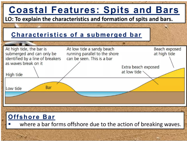
Shoals are characteristically long and narrow (linear) ridges. They can develop where a stream, river, or ocean current promotes deposition of sediment and granular material, resulting in localized shallowing (shoaling) of the water. Shoals are formed by essentially the same factors that produce offshore bars.
Offshore Bar, submerged or partly exposed ridge of sand or coarse sediment that is built by waves offshore from a beach. The swirling turbulence of waves breaking off a beach excavates a trough in the sandy bottom.

To log this Earthcache visit the viewing location. Please answer the following questions and send in a timely manner to my geocaching profile or email. Answers not received will result in deleted logs.
Questions:
1. How is the reef connected to the shore?
2. Depending on the tide level, how long was the reef the day you visited?
3. How does the tide/current impact the reef?
4. What is the reef made of?
5. Will the reef change in size, Why or why not?
6. What body of water is to the West?
7. What body of water is to the East?
8. Post a picture in your log with a personal item or hand in picture to prove you were there.
[REQUIRED] In accordance with the updated guidelines from Geocaching Headquarters published in June 2019, photos are now an acceptable logging requirement and WILL BE REQUIRED TO LOG THIS CACHE. Please provide a photo of yourself or a personal item in the picture to prove you visited the site.
Additional Hints
(No hints available.)