The Agafay desert is not a sand desert like the Sahara but is a rocky plateau, bordered on one edge by the Atlas mountains. In fact, as annual rainfall is 33cm it is not strictly a desert at all, but is classified as having a semi-arid climate. The wettest months are in the winter when intense downpours can cause flash floods that give rise to the geology you will see at the coordinates.

The coordinates are for a wadi. The term wadi comes from both the Arabic and Hebrew languages and refers to a dry riverbed that contains water during rainy seasons and is located in a valley-like area of desert.
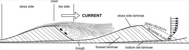
Wadis are generally located in the flat or slightly rolling areas of deserts. A wadi can be recognized by its braided appearance, which is caused by a lack of constant water flow and an excess of sediment build-up. Deposition in a wadi is rapid because of the sudden loss of stream velocity and seepage of water into the porous sediment. Wadi deposits are thus usually mixed gravels and sands. These sediments are often altered by wind which is referred to as an eolian process. Wind affects sediment build-up by bringing in dry sands that collect on top of moist sand.
Sometimes, this sediment may collect in significant amounts, blocking water flow and effectively changing the direction of the seasonal river. A typical wadi sequence consists of alternating units of wind and water sediments. Sediment laid by water generally has the coarser grains at the bottom and the finer grains at the top as the heavier grains deposit first- this is known as a fining upwards sequence. Gravels tend to be orientated with the direction of the flow of the river (ie longest edges parallel to the flow), which is known as imbrication. Wind deposits tend to be cross-stratified and covered with mud-cracked deposits. It is possible to determine the direction the wind at the time the sediments were deposited by examining the cross-stratification direction.
Ref: https://geologyistheway.com/sedimentary/cross-bedding/
The lower levels of the sediment in wadis are often packed very densely. This means that during the rainy season, water is not quickly absorbed by the ground and has nowhere to drain, which gives rise to the flash floods mentioned previously.
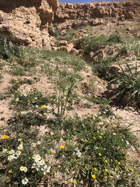
Wadi sediments are the most diverse of all desert environments. Because of the moisture that remains in the river bed even at times of drought, a wide variety of plants can grow there. When we visited the plants we saw included geraniums, daisies, and lavender. Wadis also tend to be associated with centres of human population because of sub-surface water. Nomadic desert people can exploit the seasonal vegetation found in them.
In order to log this earthcache, please email me answers to the following questions:
1. Stand at the coordinates, facing the tallest bank. What is the height at the highest point in front of you?
2. Take a close look at the tall bank. Describe its characteristics. Is it uniform or made up of layers? Why do you think it might have this structure?
3. Take a photo of you or something of yours in the wadi.