
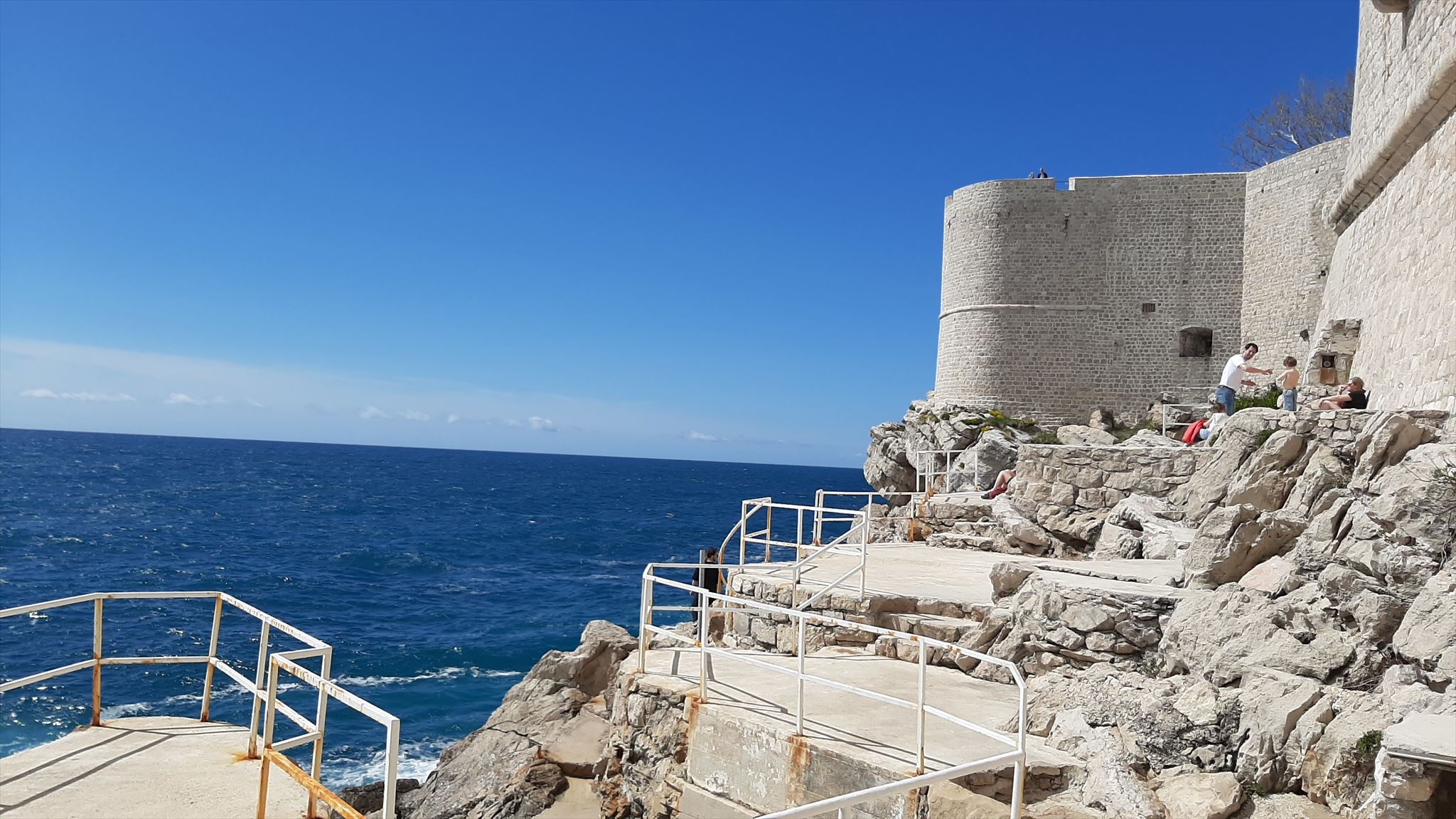
Na mnogim mjestima u gradu imate prekrasan pogled na Jadransko more i impozantne litice. Earthcache vas vodi do ruba starog grada Dubrovnika. Ovdje možete doći kroz mali prolaz u gradskim zidinama i sada stajati izravno na impresivnoj litici. Na ovom mjestu jasno se vide masivne vapnenačke litice na kojima je grad izgrađen.
Klif je dio obale bez plitkog prijelaza s mora na kopno. Kopno se strmo uzdiže i nalazi se znatno iznad razine mora. Ova vrsta obale nastala je pod utjecajem goleme sile mora. Ova snaga vode utječe i na dubrovačku obalu.

Litica se sastoji od šest različitih područja:
- Litica
- Stalak za blokove
- Škrap za surfanje
- hrpa litice
- Platforma za surfanje
- Morsko odlagalište
Međutim, samo su stijene i blokovi plaža dijelom iznad vode. Ostalo je ispod vode.
Dubrovačka hrid - dio dalmatinske obale

Dubrovnik se nalazi na obali južne Dalmacije. To uključuje istočnu obalu Jadranskog mora Hrvatske s pučinskim otocima južno od Kvarnerskog zaljeva do Boke Kotorske u Crnoj Gori. Obala duga 400 km pripada Dinarskom gorju. Sa svojim brojnim, uglavnom duguljastim otocima i tjesnacima između njih, klasičan je primjer obale Canalea.
Obala Canale je planinski lanac koji se proteže paralelno s obalom, a koji je zbog porasta mora (eustazija) utonuo u more. Antiklinale, tj. ispupčenja koja nastaju preklapanjem, teku paralelno.
Dalmatinska obala tipična je hridina s liticama od preko 300 m do gotovo 1000 m. Dalmatinski otoci nastali su kao posljedica postledenodobne ingresije, nadiranja mora na kopno Jadranskog mora. To su potopljeni grebeni i vrhovi Dinarida. Karakterističan je njihov smjer SZ-JI, koji odgovara Dinaridima. Dalmatinska obala je zbog tektonskih aktivnosti i poznato trusno područje.
Obilježja dalmatinskih klifova su geološka građa mezozojskih vapnenaca i karstifikacija.
vapnenac i karstifikacija
Vapnenac opisuje morsku sedimentnu stijenu sastavljenu prvenstveno od kalcijevog karbonata. Bijela je u svom čistom obliku, ali razne kemijske nečistoće i primjese uzrokuju da se stijena pojavi u drugim nijansama. Vapnenac na dalmatinskoj obali razvio se prije oko 250 do 65 milijuna godina u mezozoiku u morskim vodama, posebno u moru krede, od životinja poput rakova, vapnenačkih algi, koralja, dagnji i ramenonožaca, koji su nakon uginuća ostavili vapnenaste organske dijelove . One su se taložile na dno i more ih je postupno isušilo. Tijekom milijuna godina te su naslage postajale sve kompaktnije i polako su se cementirale u stabilnu masu djelovanjem minerala poput kalcita, gipsa ili dolomita. I danas se u mnogim vapnencima nalaze fosilni otisci tih bića koji su poslužili kao polazni materijal.
Zbog građe dalmatinske obale od litološki jakog vapnenca, pripada Dinarskom krsu. Ovdje se mogu vidjeti i znakovi karstifikacije, odnosno površinski i podzemni oblici reljefa koji su nastali trošenjem otopine. Kraški oblici nastaju svugdje gdje je vapnenac otopljen. To znači da je kamen zamijenjen vodom, što je prirodno
sadrži kiseline. Za razliku od većine drugih vrsta kamena, ovo posebno dobro funkcionira s vapnom.
Dobro pogledajte lokalne litice i stijene, a zatim odgovorite na sljedeća pitanja prije prijave:
1. Opiši vapnenac pod gradskim zidom po slojevima i nagibu!
2. Možete li pronaći fosilne ostatke drevnih morskih stvorenja?
3. Koje znakove karstifikacije možete vidjeti na stijenama?
4. Koja područja litice možete vidjeti ovdje i zašto ne možete vidjeti druga područja?
5. Fotografirajte sebe ili neki osobni predmet ispred dubrovačke hridi i pričvrstite to na svoj log!
Pošaljite mi e-mail sa svojim odgovorima! Možete se prijaviti odmah nakon slanja odgovora. Ako nešto nije u redu, javit ću vam. Ne morate čekati objavu dnevnika! Nadam se da ćete uživati u ovom geološkom putovanju otkrića!

At many places in the city you have a wonderful view of the Adriatic Sea and the imposing cliffs. The Earthcache leads you to the edge of the old town of Dubrovnik. You can get here through a small passage in the city wall and now stand directly on the impressive cliff. At this point you can clearly see the massive limestone cliffs on which the city was built.
A cliff is a stretch of coastline without a shallow transition from the sea to the mainland. The mainland rises steeply and is well above sea level. This type of coast was formed by the enormous force of the sea. This force of the water also influences the coast of Dubrovnik.
A cliff consists of six different areas:
- Cliff
- Block stand
- Surf scarp
- Cliff pile
- Surf platform
- Sea dump
However, only the cliff and block beach is partly above the water. The rest is below the water.
The Dubrovnik cliff - part of the Dalmatian Coast
Dubrovnik is located on the southern Dalmatian coast. This includes the east coast of the Adriatic Sea from Croatia with the offshore islands south of the Kvarner Bay to the Bay of Kotor in Montenegro. The 400-kilometre-long coastline is part of the Dinaric Mountains. With its numerous, mostly long islands and the sea lanes in between, it is the classic example of the Canal Coast.
The Canal Coast is a mountain range running parallel to the coast, which has sunk into the sea due to the rise of the sea (eustasie). The anticlines, i.e. uplifts created by folding, run parallel.
The Dalmatian coast is a typical steep coast with cliffs ranging from over 300 m to almost 1000 m. The Dalmatian islands were formed by post-glacial ingression, the advance of the sea onto the mainland of the Adriatic. These are flooded ridges and crests of the Dinarides. Their NW-SE strike direction, which corresponds to the Dinarides, is characteristic. Due to tectonic activity, the Dalmatian coast is also a known earthquake area.
Characteristics of the Dalmatian cliffs are the geological structure of Mesozoic limestones and karstification.
Limestone and karstification
Limestone describes a marine sedimentary rock composed mainly of calcium carbonate. It is white in colour in its pure form, but various chemical impurities and admixtures mean that the rock can also appear in other shades. The limestone on the Dalmatian coast developed about 250 to 65 million years ago in the Mesozoic in marine waters, especially in the Cretaceous Sea, from animals such as crabs, calcareous algae, corals, mussels and arthropods, which left behind calcareous organic parts after they died. These were deposited on the bottom and gradually drained as the sea receded. In the course of millions of years, these deposits became more and more compacted and were slowly cemented into a stable mass under the influence of minerals such as calcite, gypsum or dolomite. Even today, many limestones still contain the fossil imprints of the creatures that served as the source material.
Because the Dalmatian coast is made up of lithologically solid limestones, it belongs to the Dinaric Karst. Signs of karstification, i.e. above- and below-ground terrain forms created by solution weathering, can also be seen here. Karst forms occur wherever limestone is dissolved. This means that the rock is dissolved by water, which contains natural acids.
which contains natural acids. In contrast to most other types of rock, this works particularly well with limestone.
Take a close look at the cliff and the rocks on site and then please answer the following questions before logging.
1. Describe the limestone under the city wall in terms of its stratification and inclination!
2. Can you find fossil remains of former sea creatures?
3. What signs of karstification can you see on the rocks?
4. Which parts of the cliff can you see here and why can't you see the other parts?
5. Take a photo of yourself or a personal object in front of the Dubrovnik cliff and hang it on your log!
Send me an email with your answers! After sending your answers, you can log right away. If something is wrong, I will contact you. You don't have to wait for the log to be released! Have fun on this geological journey of discovery!

An vielen Stellen in der Stadt hat man einen wunderbaren Blick auf die Adria und die imposante Steilküste. Der Earthcache führt euch an den Rand der Altstadt von Dubrovnik. Durch einen kleinen Durchgang in der Stadtmauer gelangt ihr hierher und steht nun direkt auf dem beeindruckenden Kliff. An dieser Stelle könnt ihr gut die massiven Kalksteinfelsen sehen auf denen die Stadt gebaut wurde.
Eine Steilküste ist ein Küstenabschnitt ohne seichten Übergang vom Meer zum Festland. Das Festland ragt steil in die Höhe und befindet sich deutlich über dem Meeresspiegel. Geformt wurde diese Art der Küste durch die enorme Kraft des Meeres. Diese Kraft des Wassers beeinflusst auch die Küste von Dubrovnik.
Eine Steilküste besteht aus sechs verschiedenen Bereichen:
- Kliff
- Blockstrand
- Brandungshohlkehle
- Kliffhalde
- Brandungsplattform
- Seehalde
Allerdings ist nur die Kliff und der Blockstrand zum Teil oberhalb des Wassers. Der Rest befindet sich unterhalb des Wassers.
Die Steilküste von Dubrovnik - Teil der Dalmatinischen Küste
Dubrovnik liegt an der südlichen Dalmatinischen Küste. Diese umfasst die Ostküste des Adriatischen Meeres von Kroatien mit den vorgelagerten Inseln südlich der Kvarner Bucht bis zur Bucht von Kotor in Montenegro. Die 400 Kilometer lange Küste gehört zum Dinarischen Gebirge. Mit ihren zahlreichen, meist langgezogenen Inseln und den dazwischen liegenden Meeresstraßen ist sie das klassische Beispiel der Canaleküste.
Bei der Canaleküste handelt es sich um ein parallel zur Küste verlaufendes Gebirge, das durch den Meeresanstieg (Eustasie) im Meer versunken ist. Die Antiklinalen, also durch Faltung erzeugten Aufwölbungen, verlaufen parallel.
Die Dalmatinische Küste ist eine typische Steilküste mit Kliffen von über 300 m bis nahezu 1000 m. Durch die nacheiszeitliche Ingression, das Vordringen des Meeres auf das Festland der Adria, bildeten sich die Dalmatinischen Inseln. Diese sind überflutete Rücken und Kämme der Dinariden. Kennzeichnend ist ihre NW-SO-Streichrichtung, die den Dinariden entspricht. Durch tektonische Aktivität ist die Küste Dalmatiens auch ein bekanntes Erdbebengebiet.
Kennzeichen der Dalmatischen Steilküste sind der geologische Aufbau aus mesozoischen Kalksteinen und die Verkarstung.
Kalkstein und Verkarstung
Kalkstein beschreibt ein marines Sedimentgestein, das hauptsächlich aus Calciumcarbonat besteht. Es ist in seiner reinen Form von weißer Farbe, verschiedene chemische Verunreinigungen und Beimengungen führen jedoch dazu, dass das Gestein auch in anderen Farbtönen erscheinen kann. Der Kalkstein an der Dalmatinischen Küste entwickelte sich vor ca. 250 bis 65 Millionen Jahren im Mesozoikum in marinen Gewässern, vor allem im Kreidemeer, aus Tieren wie Krebsen, Kalkalgen, Korallen, Muscheln und Armfüßern, die nach dem Absterben kalkhaltige organische Teile hinterließen. Diese lagerten sich am Grund ab und wurden durch das Zurückgehen des Meeres allmählich entwässert. Im Laufe von Millionen von Jahren verdichteten sich diese Ablagerungen immer mehr und wurden unter Einwirkung von Mineralien wie Calcit, Gips oder Dolomit langsam zu einer stabilen Masse verkittet. Noch heute finden sich in vielen Kalksteinen die fossilen Abdrücke jener Lebewesen, die als Ausgangsmaterial dienten.
Durch den Aufbau der Dalmatinischen Küste aus lithologisch festen Kalksteinen gehört diese zum Dinarischen Karst. Anzeichen der Verkarstung, also ober- und unterirdische Geländeformen die durch Lösungsverwitterung entstanden sind, sieht man auch hier. Karstformen entstehen überall dort, wo Kalkstein gelöst wird. Damit meint man, dass sich das Gestein durch Wasser, welches natürliche
Säuren enthält, auflöst. Im Gegensatz zu den meisten anderen Gesteinsarten geht das bei Kalk besonders gut.
Schaut euch das Kliff und die Felsen vor Ort genau an und beantwortet dann bitte vor dem Loggen folgende Fragen:
1. Beschreibt den Kalkstein unter der Stadtmauer bezüglich seiner Schichtungen und Neigung!
2. Könnt ihr fossile Überreste ehemaliger Meeresbewohner finden?
3. Welche Anzeichen der Verkarstung könnt ihr an den Felsen erkennen?
4. Welche der Bereiche einer Steilküste könnt ihr hier sehen und warum könnt ihr die anderen Bereiche nicht sehen?
5. Macht ein Foto von euch oder einem persönlichen Gegenstand vor dem Kliff von Dubrovnik und hängt es an euren Log!
Schickt eine Mail mit euren Antworten an mich! Nach dem Absenden der Antworten könnt ihr gleich loggen. Falls etwas nicht in Ordnung ist, melde ich mich. Ihr braucht nicht die Logfreigabe abwarten! Ich wünsche euch viel Spaß bei dieser geologischen Entdeckungsreise!

Quellen: wikipedia, mineralienatlas.de, studysmarter.de