Kotorske ljestve, poznate i kao Cattarove ljestve, povijesna su stjenovita serpentinasta staza koja vas od Kotora vodi u zonu visokog krša u Crnoj Gori. Ovdje se kaže: Put je cilj! Isplati se napor puta preko najmanje 65 skretnica, jer se na vrhu pruža fantastičan pogled na Boku kotorsku.
O kotorskim ljestvama
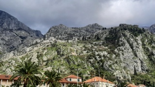
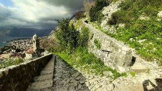
Kotorske ljestve su stjenovita staza koja se serpentinama penje uz planinski lanac Lovćen istočno od Starog grada Kotora. Staza vodi iza malog grebena na kojem su izgrađene gradske zidine kotorske tvrđave i vodi do prevoja Krstac na nadmorskoj visini od 940 metara. Ova staza je i značajna i povijesna jer je stoljećima bila jedina veza između Kotora i Njeguša i Cetinskog kraja. Stalna skretanja omogućuju manje strm uspon, omogućujući putnicima sa stokom i robom da prijeđu ovaj planinski lanac.
Zona visokog krša Crne Gore
Na geološkoj karti Boka Kotorska se jasno vidi između zone Pindus Cukali označene crvenom bojom i zone visokog krša označene svijetlo plavom bojom. Uvala se više od 1000 m duboko usjekla u okolne krške planine Orjen i Lovčen. Zona visokog krša ili pokrov visokog krša je tektonska jedinica Balkanskog poluotoka. Ova tektonska jedinica sastoji se od stratigrafskih naslaga u rasponu od gornje krede u mezozoiku do eocena u kenozoiku. Naslage su započele s morskim sedimentima gornje krede prije otprilike 100 milijuna godina. U ranom trijasu, prije 250 milijuna godina, taloženi su uski morski karbonati i sedimenti silikatnih minerala kao dokaz uvjeta na šelfu. U srednjem trijasu, oko 10 milijuna godina kasnije, tada su prevladavali dubokomorski uvjeti. Još 40 milijuna godina kasnije, u kasnom trijasu, uvjeti taloženja postali su plitki i počela se formirati karbonatna platforma. To je trajalo do eocena, prije oko 56 milijuna godina, kada su dodani flišni sedimenti.
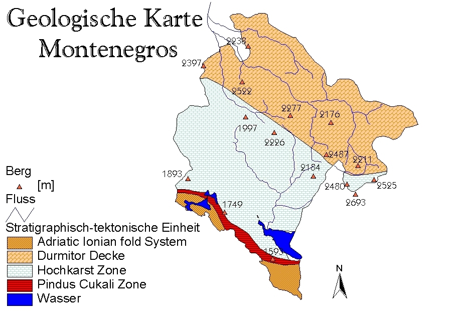
Geološki gledano, vapnenci iz razdoblja krede i jure debeli su najmanje 4,3 kilometra. Zbog monotonije masivnih mezozojskih vapnenaca i velike ukupne količine oborina, područje je izrazito kršovito.
Dinarski krš ili "vrtački krš" tip je sredozemnog krša karakteriziran vrtačkim bogatstvom (zdjelasta ili ljevkasta udubljenja), velikim poljem (prostrani zatvoreni šupljinasti oblici u kršu s ravnim dnom) i površinskim siromaštvom vode. Rasprostranjena je u mediteranskom bazenu. Sve visoke planine Dinarskog krša doživjele su snažnu glacijaciju, osobito tijekom mindelske glacijacije.
Slojevi vapnenca su masivni ili slojeviti. Općenito, kredne karbonatne serije u Orjenu mnogo su jače naborane od jurskih vapnenaca u susjednom Lovčenu. Budući da masivni jurski karbonati nisu jako slojeviti, bili su puno manje nabrani. U pravilu se može uočiti pad vapnenačkih slojeva od 45°. Fosili ili fosilni ostaci mogu se pronaći u mnogim vapnencima.
Idite na Kotorske ljestve, uživajte u prekrasnom pogledu s vrha i odgovorite na sljedeća pitanja prije prijave:
1. Djeluju li stijene oko Kotorskih ljestava masivnije ili slojevitije?
2. Možete li vidjeti nabore u vapnencima?
3. Opiši oblik krajolika iza zida prema planini!
4. Gdje se na putu mogu naći fosili i kako oni izgledaju?
5. Fotografirajte sebe/svoj GPS ili osobni predmet na vrhu zadanih koordinata i priložite to svom dnevniku!
Pošaljite mi e-mail sa svojim odgovorima! Nakon slanja odgovora možete se odmah prijaviti. Ako nešto nije u redu, kontaktirat ću vas. Ne morate čekati da se dnevnik objavi! Zabavite se na ovom geološkom putovanju otkrića!

The Ladder of Kotor, also known as the Ladder of Cattaro, is a historic rocky serpentine path and leads you from Kotor up into the Montenegrin high karst zone. Here the motto is: the way is the goal! The effort of the path over at least 65 serpentines is worth it, because once you reach the top you can enjoy a fantastic view of the Bay of Kotor.
In the summer months, you have to pay an entrance fee of currently 8 euros. In the low season, admission is free.
About the Ladder of Kotor
The Ladder of Kotor is a rocky path that winds up the Lovćen mountain range east of the old town of Kotor via switchbacks. The path runs behind the small ridge on which the city walls of Kotor Fortress are built, and leads up to the Krstac Pass at an altitude of 940 metres above sea level. This path is both significant and historical, as for centuries it was the only connection between Kotor and the village of Njegusi and the region of Cetinje. The constant serpentines make for a less steep ascent, allowing travellers with livestock and goods to cross this mountain range.
The High Karst Zone of Montenegro
On the geological map, the Bay of Kotor is clearly visible between the Pindus Cukali Zone marked in red and the High Karst Zone marked in light blue. The bay is cut over 1000 m deep into the surrounding karst mountains of Orjen and Lovčen. The High Karst Zone or High Karst Cover is a tectonic unit of the Balkan Peninsula. This tectonic unit consists of stratigraphic deposits ranging from the Upper Cretaceous in the Mesozoic to the Eocene in the Cenozoic. The deposits began with marine sediments of the Upper Cretaceous about 100 million years ago. In the Early Triassic, 250 million years ago, narrow marine carbonates and sediments of silicate minerals were deposited as a sign of shelf conditions. Then in the Middle Triassic, about 10 million years later, deep-sea conditions prevailed. Another 40 million years later, in the Late Triassic, depositional conditions became shallower, whereupon the carbonate platform began to form. This lasted until the Eocene, about 56 million years ago, when flysch sediments were added.
Geologically, the Cretaceous and Jurassic limestones are at least 4.3 kilometres thick. Due to the monotony of the massive Mesozoic limestones and the high precipitation totals, the region is extremely karstified.
Dinaric karst or "sinkhole karst" is a type of Mediterranean karst characterised by sinkhole richness (bowl- or funnel-shaped depressions), large polje (extensive closed hollow forms in karst with a flat bottom) and superficial water poverty. It is widespread in the Mediterranean basin. All the high mountains of the Dinaric Karst have experienced strong glaciation, especially during the Mindel glaciation.
The limestone layers are massive or stratified. In general, the Cretaceous carbonate series in Orjen are much more folded than the Jurassic limestones in neighbouring Lovčen. Since the massive Jurassic carbonates are not very stratified, they were folded much less. As a rule, a dip of the limestone layers of 45° can be observed. Fossils or fossil remains can be found in many limestones.
Go to the Ladder of Kotor, enjoy the great view from the top and then please answer the following questions before logging:
1. Do the rocks around the Kotor ladder seem more massive or layered?
2. Can you see folds in the limestones?
3. Describe the shape of the landscape behind the wall towards the mountain!
4. Where can you find fossils on your way and what do they look like?
5. Take a photo of you/your GPS or a personal object in the window in the wall and attach it to your log!
Send me an email with your answers! After sending your answers you can log right away. If something is wrong, I will contact you. You don't have to wait for the log to be released! Have fun on this geological journey of discovery!

Die Leiter von Kotor, auch als Leiter von Cattaro bekannt, ist ein historischer felsiger Serpentinenpfad und führt euch von Kotor aus hinauf in die montenegrische Hochkarstzone. Hier heißt es: Der Weg ist das Ziel! Die Anstrengung des Weges über mindestens 65 Serpentinen lohnt sich, denn oben angekommen könnt ihr einen phantastischen Blick auf die Bucht von Kotor genießen.
In den Sommermonaten müsst ihr ein Eintrittsgeld von zur Zeit 8 Euro bezahlen. In der Nebensaison ist der Eintritt frei.
Über die Leiter von Kotor
Die Leiter von Kotor ist ein felsiger Pfad, der sich über Serpentinen die Bergkette des Lovćen östlich der Altstadt von Kotor hinaufschlängelt. Der Weg verläuft hinter dem kleinen Kamm, auf dem die Stadtmauern der Festung Kotor gebaut sind, und führt bis zum Krstac-Pass auf eine Höhe von 940 Metern über dem Meeresspiegel. Dieser Weg ist sowohl bedeutsam als auch historisch, denn er war jahrhundertelang die einzige Verbindung zwischen Kotor und dem Dorf Njegusi und der Region von Cetinje. Die ständigen Serpentinen ermöglichen einen weniger steilen Aufstieg, so dass die Reisenden mit Vieh und Waren über diesen Gebirgszug fahren können.
Die Hochkarstzone von Montenegro
Auf der geologischen Karte ist die Bucht von Kotor zwischen der rot markierten Pindus Cukali Zone und der hellblau markierten Hochkarst Zone gut zu erkennen. Über 1000 m tief ist die Bucht in die umgebenden Karst-Gebirge von Orjen und Lovčen eingeschnitten. Die Hochkarst-Zone oder Hochkarst-Decke ist eine tektonische Einheit der Balkanhalbinsel. Diese tektonische Einheit besteht aus stratigraphischen Ablagerungen die von der Oberkreide im Mesozoikum reichen bis in das Eozän im Känozoikum reichen. Die Ablagerungen begannen mit marinen Sedimenten der Oberkreide vor etwa 100 Millionen Jahren. In der frühen Trias, vor 250 Millionen Jahren, wurden schmale marine Karbonate und Sedimente aus Silikatmineralen als Zeichen von Schelfbedingungen abgelagert. In der mittleren Trias, etwa 10 Millionen Jahre später, herrschten dann Tiefseezustände. Weitere 40 Millionen Jahre später, in der späten Trias wurden die Ablagerungensbedingungen seichter, worauf die Karbonatplattform sich zu bilden begann. Dies dauerte bis ins Eozän, vor etwa 56 Millionen Jahren, als Flyschsedimente hinzukamen.
Geologisch kennzeichnend sind die mindestens 4,3 Kilometer mächtigen kreide- und jurazeitlichen Kalksteine. Aufgrund der Eintönigkeit der massigen mesozoischen Kalke und der hohen Niederschlagssummen ist die Region extrem verkarstet.
Dinarischer Karst oder „Dolinenkarst“ ist Typform des mediterranen Karstes, der durch Dolinen-Reichtum (schüssel- oder trichterförmige Senken), Großpoljen ( ausgedehnte geschlossene Hohlformen im Karst mit ebenem Boden) und oberflächliche Wasserarmut gekennzeichnet ist. Er ist im mediterranen Becken verbreitet. Alle Hochgebirge des Dinarischen Karstes haben insbesondere währende der Mindel-Kaltzeit eine starke Vergletscherung erfahren.
Die Kalkschichten sind massig oder geschichtet. Allgemein sind die kreidezeitlichen Karbonatserien im Orjen sehr viel stärker gefaltet als es die jurazeitlichen Kalksteine im benachbarten Lovčen sind. Da die massiven jurazeitlichen Karbonate wenig geschichtet sind, wurden sie viel weniger stark gefaltet. In der Regel kann ein Einfallen der Kalkschichten von 45° beobachtet werden. In vielen Kalksteinen findet man Fossilien oder Fossilienreste.
Begebt euch auf die Leiter von Kotor, genießt die tolle Aussicht von oben und beantwortet dann bitte vor dem Loggen folgende Fragen:
1. Erscheinen euch die Felsen rund um die Leiter von Kotor eher massig oder geschichtet?
2. Könnt ihr Falten in den Kalksteinen erkennen?
3. Beschreibt die Landschaftsform hinter der Mauer Richtung Berg!
4. Wo könnt ihr auf eurem Weg Fossilien entdecken und wie sehen diese aus?
5. Mache bitte ein Foto von dir/deinem GPS oder einem persönlichen Gegenstand im Fenster in der Wand und füge es deinem Log bei!
Schickt eine Mail mit euren Antworten an mich! Nach dem Absenden der Antworten könnt ihr gleich loggen. Falls etwas nicht in Ordnung ist, melde ich mich. Ihr braucht nicht die Logfreigabe abwarten! Ich wünsche euch viel Spaß bei dieser geologischen Entdeckungsreise!

Quellen: wikipedia, mineralienatlas.de