Stenhouse Bay is home to an interesting geological feature known as a "flared slope" or "concave slope".
Flared slopes are characterized by a curved or bowl-like shape. These slopes are most commonly found in areas where sedimentary rocks are exposed to weathering and erosion, such as in mountainous regions or along coastal cliffs.
Flared slopes are created through a combination of different factors, including the type of rock that is present and the forces of erosion.
(Source: http://furneauxgeotrail.flinders.tas.gov.au/)
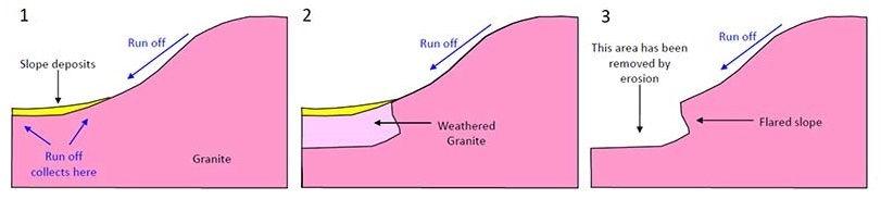
Flared slopes are most commonly found in granite, with the specimen in this EarthCache being no exception. Due to granite being more resistant to water erosion, it means that the rock isn't weathered away by precipitation directly. Instead, the water pools at the bottom and it gives it enough time to penetrate weak spots in the ground until collapse (as seen in the diagram above).
Despite granite slopes not being weathered by precipitation directly, the water does run down the slope before pooling at the bottom. This can be determined as the cause of the creation of a flared slope as streaks present themselves on the rock face; this is due to the breaking down of the chemicals in the stone. These chemicals are then redeposited when running down the slope, leaving the markings behind.
Flared slopes can have a variety of different angles, ranging from gentle slopes to steep cliffs. The angle of the slope is determined by the type of rock that is present, as well as the amount of erosion that has occured. The steeper the slope is, the longer the erosion processes lasted. In some cases. In some cases, flared slopes can be unstable and prone to landslides or falling rocks, particularly if they are composed or loose or poorly consolidated material.
Flared slopes are important as they provide a glimpse into the forces of erosion and weathering that shape rock faces.
Logging requirements:
Q1. Is the slope at Stenhouse Bay the result of high or low amounts of erosion? Why do you give this answer?
Q2. Do you think there are other factors that can determine the amount of erosion that has occurred?
Q3. What evidence can you give to determine that this slope was created by precipitation and pooling?
Q4. Take a photo of you, your stamp or personal item from the jetty with the slope in the background. Photos from the carpark will be not be accepted.
Please send answers via the Geocaching message centre or to my email, answers posted in the logs will be deleted.
You can log the find immediately, however, if answers are not supplied to CO within 14 days, your log will be deleted.
Stenhouse Bay is part of the Innes National Park so please make sure all entry fees are paid and no dogs are taken in.
Happy caching!
I have reached the GSA's highest level: