Volcanic Mudflows - The Dangers of Lahars
An educational review of the dangers of lahars and their geologic importance to the Orting Valley
Welcome to Orting! This Earthcache is dedicated to the fascinating geological phenomenon of lahar flows. Lahars are volcanic mudflows formed when volcanic ash and debris mix with water, creating a fast-moving and potentially destructive erosive force. In this cache, you will delve into the formation, characteristics, and impacts of lahar flows. Join us on this journey to explore nature's powerful sculptors!

As a reminder, this is an Earthcache which means there is no container to find at the posted coordinates! Rather you must read through this lesson, make observations on site, and then send your answers to the questions at the bottom of this page to the cache owner in order to log this as found!
What are Lahar Flows?
Lahars are unique geological events associated with volcanic activity. They occur when volcanic ash and debris become saturated with water, either from heavy rainfall or the melting of snow and ice on a volcano's slopes. This mixture of water and loose volcanic material creates a dense mudflow that can travel swiftly down the volcano's flanks, valleys, and even into surrounding communities. Lahars are primarily formed through a series of events. First, a volcanic eruption produces a cloud of ash and rock fragments that are ejected into the atmosphere. This ashfall accumulates on the volcano's slopes and nearby areas. Subsequent rainfall or the melting of snow and ice can infiltrate these loose deposits, transforming them into a slurry of water and volcanic material. Gravity then propels this mixture downslope, creating a lahar flow.
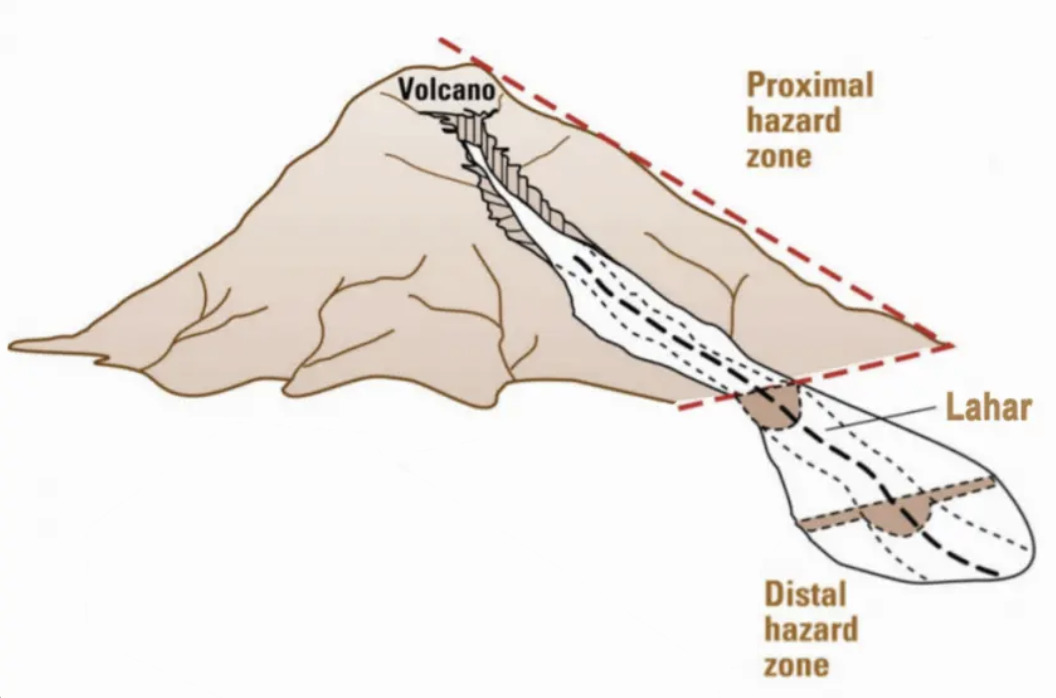 Lahar flows possess distinctive characteristics that make them both intriguing and dangerous. They exhibit a wide range of viscosities, ranging from watery slurries to more solid masses. Their composition varies depending on the type of volcano and the materials involved, including volcanic ash, rock fragments, and water. Lahars can travel at high speeds, reaching velocities of up to 50 miles per hour (80 km/h), which allows them to cover vast distances and cause significant damage. The impacts of lahar flows can be devastating to both natural and human environments. Due to their rapid movement and sheer force, lahars can erode and reshape the landscape, carving deep channels and removing vegetation. They can also bury entire towns and infrastructure, resulting in the loss of lives and livelihoods. Additionally, lahars pose a significant risk to water sources, as they can contaminate rivers and lakes, impacting ecosystems and human populations downstream.
The Orting Valley
About 550 years ago, hydrothermally-altered rock broke loose from the weakened upper west slope of Mount Rainier. It rushed into the Puyallup River drainage and produced the Electron Lahar Mudflow that overran the present site of Orting with about twenty feet of rocks and mud before flowing to Puget Sound. This event, along with many others in prehistoric history are what made the Orting Valley such a fertile location for crops. The volcanic material in the soil, deposited over many years has made Orting a great place to farm - as you drove to this Earthcache you probably noticed several farmers fields - underscoring the continuing importance of lahars to this region.
These historic lahars made Orting a valuable place to live in terms of the agricultural industry, but because Mt. Rainier is still an active volcano, it also poses a huge risk to the community as well. As noted in a 1999 Discover News Article:
"Mount Rainier, the highest point in the Cascades, is not just lovely scenery. It's the most dangerous volcano in the United States. When it erupts— and it will— blistering avalanches of incandescent rock, lava, and ash will sweep down the volcano. Worse, unimaginably large flows of mud hundreds of feet deep, called lahars, filled with melted ice, boulders, and whole forests of uprooted trees, will pour down adjacent river valleys at upward of 25 miles an hour. Like concrete cascading down the chute of a cement truck, the lahars will entomb everything in their path."
The Washington Department of Natural Resources recommends that if you're evacuating from a lahar you usually need only to climb 75-100 yards up the valley walls to escape from the lahar slide. Orting is particuarly susceptible to lahar flows as the town is situated at the joint of a "Y" in the rivers - just a few hundred yards from where you now stand - where the convergence of the Carbon and Puyallup rivers meet. By the time a big Lahar would hit Orting, it could be as deep as 40-50 ft. That's a BIG mudwave!
Questions
Please review the text above and use the signage on scene and your own observations at GZ to develop answers to the below questions. In order to claim your smiley you must complete all the requisite tasks below.
- Using the Department of Natural Resources Graphic at Ground Zero, what are three other towns that have a higher risk of being innundated by a lahar than Orting? Explain why these towns might be at a greater risk.
- Walk a few feet to the north and estimate the distance between the river and the bottom of the current highway bride that serves as the only way out of Orting. Given that a lahar could be as high as 40-50 ft, predict if this bridge would still be availalbe for residents to use to escape after a lahar arrives.
- As you are reading this question you hear the Lahar alarms start to sound. You use a topographical map (I recommend Google Topo Maps) to examine your escape options. Based on the reading above, where is the best location for you to make a run for it?
- Using the same topographic map, explain why GZ is likely incredibly suscepitble to lahar flow (hint: look at the change in elevation across both river banks).
- PHOTO: Please take a photo of yourself, a trackable, or a piece of paper with your GeoHandle on it in front of a recognizable area of GZ (may I humbly recommend that bridge to the North of you?).
References