Deutsch siehe unten
English see below
Affouillement à la Chapelle Saint-Quirin
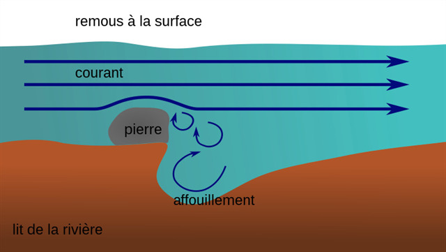
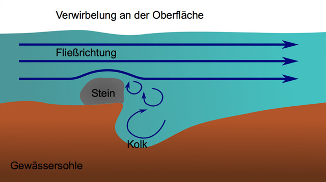
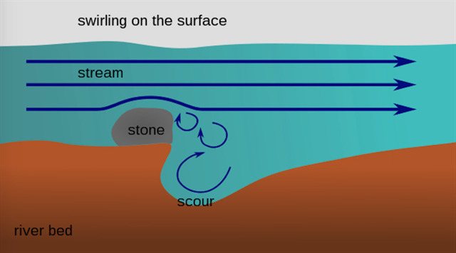
Un affouillement est un phénomène d'érosion du lit d'une rivière sous la forme d'une dépression dans le lit de la rivière ou le mur de la berge. Les irrégularités dans la résistance du sous-sol peuvent être des déclencheurs ou des obstacles à l'écoulement tels que des racines d'arbres ou des pierres dans des lits de sable et de gravier. Des affouillements se forment également dans la roche dure en raison de la dynamique fluviale du cours d'eau. Les fragments de sable et de roche qui sont transportés abrasent le fond de la rivière, provoquant l'érosion de la roche par la rivière. Les affouillements et les rouleaux d'eau créent des dépressions en forme d'entonnoir ou de chaudron. L'activité d'affouillement de l'eau qui coule est appelée évorsion, la forme initiale d'une niche de tourbillon d'affouillement.
Des affouillements se forment également dans la zone de surf sur les côtes des falaises, ainsi qu'à travers les eaux de fonte sous les glaciers, qui s'écoulent parfois sous haute pression : marmites glaciaires.
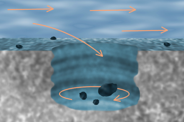
Lorsque la surface rocheuse est recouverte par un glacier, la glace fond souvent à la surface du glacier, par exemple en été. L'eau de fonte coule à la surface, atteint un puits appelé moulin à glacier et pénètre dans une grotte glaciaire. Normalement, l'eau fait fondre le puits dans la glace jusqu'au substrat rocheux, d'où elle s'écoule à la surface de la roche à travers une grotte glaciaire. Le marmite glaciaire se forme au point où l'eau, après avoir traversé le puits, atteint le substratum rocheux.
Si des tourbillons se forment ici, des vitesses d'écoulement allant jusqu'à 200 km/h et une pression élevée peuvent survenir. Le travail d'érosion du lit rocheux est formé par des particules de sable et de gravier entraînées. Un pot glaciaire peut mesurer jusqu'à 15 mètres de large.
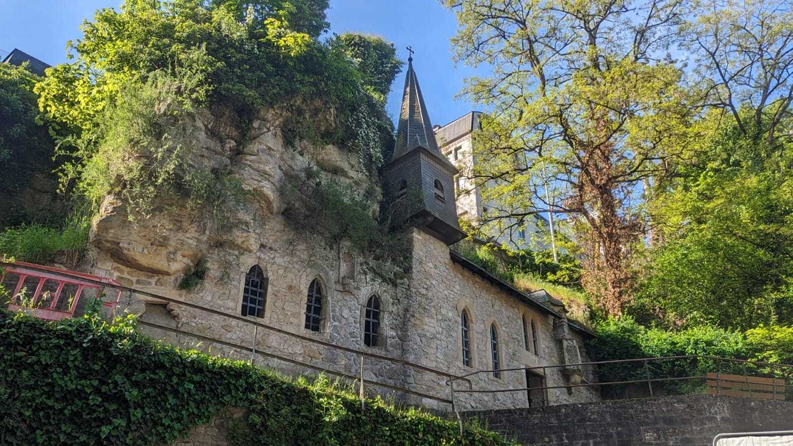
Si vous montez les marches de la vallée jusqu'à la chapelle du Quirinus, vous trouverez plusieurs affouillement à gauche des dernières marches devant la chapelle, que la rivière a autrefois laissées ici. Malheureusement, ceux-ci ont été partiellement enlevés lors de la construction de la chapelle et de la construction du chemin, mais la plupart d'entre eux sont encore intacts.
En raison de l'érosion fluviale, la rivière s'est creusée beaucoup plus profondément dans le lit du ruisseau pendant des milliers d'années, de sorte que les affouillement sont maintenant à sec.
Earthcache
"Loguez cette cache "Found it" et envoyez-moi vos propositions de réponses soit via mon profil, soit via la messagerie geocaching.com (Message Center), et je vous contacterai en cas de problème."
1.) Décrivez dans vos propres mots comment les affouillement se sont formées ici.
2.) Quelle est la différence entre affouillement et marmite glaciaire?
3.) Pourquoi l'affouillement a-t-il cessé de croître et ne grossira-t-il pas à l'avenir ?
4.) Regardez attentivement la surface de l'affouillement. Pouvez-vous voir des marques de meulage?
5.) Prenez une photo de vous ou d'un objet personnel devant la chapelle et téléchargez-la dans votre journal.
Sources:
Photo: RauGeo
Graphique: https://de.wikipedia.org
Texte: https://de.wikipedia.org
www.showcaves.com
www.mineralienatlas.de
Kolk an der Quirinuskapelle
Ein Kolk ist eine Erosionserscheinung in einem Flussbett in Form einer Vertiefung in der Fließgewässersohle oder der Uferwand. Auslöser können Unregelmäßigkeiten in der Festigkeit des Untergrundes sein oder Fließhindernisse wie Baumwurzeln oder Steine in Sand- und Schotterbetten. Kolke entstehen auch in Festgestein durch die Fluvialdynamik des Wasserlaufs. Mitgeführter Sand und Gesteinsbruchstücke schleifen die Gewässersohle ab, wodurch der Fluss das Gestein erodiert. Durch Strudel und Wasserwalzen bilden sich trichter- oder kesselförmige Vertiefungen. Die auskolkende Tätigkeit des fließenden Wassers heißt Evorsion, die Initialform eines Kolks Strudelnische.
Kolke bilden sich auch im Brandungsbereich an Kliffküsten, sowie durch – teils unter hohem Druck fließendes – Schmelzwasser unter Gletschern: Gletschertöpfe.
Wenn die Felsoberfläche von einem Gletscher bedeckt ist, schmilzt das Eis oft an der Oberfläche des Gletschers, zum Beispiel im Sommer. Das Schmelzwasser fließt an der Oberfläche, erreicht einen Schacht, der Gletschermühle genannt wird, und tritt in eine Gletscherhöhle ein. Normalerweise schmilzt das Wasser den Schacht in das Eis bis zum Grundgestein, von wo aus es an der Oberfläche des Gesteins durch eine Gletscherhöhle bergab fließt. Der Gletschertopf entsteht an dem Punkt, an dem das Wasser nach dem Herabfallen durch den Schacht das Grundgestein erreicht.
Wenn sich hier Wirbel bilden, können Fließgeschwindigkeiten von bis zu 200 km/h und ein hoher Druck entstehen. Die Aushöhlung, Erosionsarbeit des Felsenbettes wird durch mitgeführte Sand und Kiespartikel gebildet. Ein Gletschertopf kann bis zu 15 Meter groß werden.
Wenn du vom Petrusstal die Stufen zur Quirinuskapelle hinauf gehst, findest du direkt neben den letzten Stufen vor der Kapelle auf der linken Seite gleich mehrere Kolke, die der Fluss einst hier hinterlassen hat. Leider wurden diese beim Bau der Kapelle und bei Errichtung des Weges teilweise abgetragen, aber der Großteil ist noch erhalten.
Durch die Flusserosion hat sich der Fluss über tausende von Jahren deutlich tiefer in das Bachbett eingegraben, sodass die Kolke heute trocken liegen und nicht mehr weiter ausgerieben werden.
Earthcache
Um den Earthcache zu loggen beantworte die Fragen und sende mir die Antworten entweder über mein Profil oder über geocaching.com (Message Center) zu. Erst nach dem Senden der Antworten darfst du den Cache als gefunden loggen. Eine Logerlaubnis braucht nicht abgewartet zu werden. Sollte es Unklarheiten geben, werde ich mich bei dir melden und dir bei der Findung der richtigen Lösung helfen.
1.) Beschreibe mir mit eigenen Worten, wie die Kolke hier entstanden sind.
2.) Was ist der Unterschied zwischen Kolk und Gletschertopf?
3.) Warum hat der Kolk aufgehört zu wachsen und wird in Zukunft auch nicht mehr größer werden?
4.) Schau dir die Oberfläche des Kolks genau an. Kannst du Schleifspuren von der Entstehung erkennen?
5.) Mache ein Foto von dir oder einem persönlichen Gegenstand vor der Kapelle und lade es zu deinem Log hoch.
Quellen:
Foto: RauGeo
Grafik: https://de.wikipedia.org
Text: https://de.wikipedia.org
www.showcaves.com
www.mineralienatlas.de
Scour at the Chapel of St. Quirinus
A scour is an erosion phenomenon in a river bed in the form of a depression in the river bed or the bank wall. Irregularities in the strength of the subsoil can be triggers, or flow obstacles such as tree roots or stones in sand and gravel beds. Scours also form in hard rock due to the fluvial dynamics of the watercourse. The sand and rock fragments that are carried along abrade the bottom of the river, causing the river to erode the rock. Swirls and water rolls create funnel- or cauldron-shaped depressions. The scouring activity of the flowing water is called evorsion, the initial form of a scour whirlpool niche.
Scours also form in the surf area on cliff coasts, as well as from meltwater under glaciers, some of which flows under high pressure. These are called giant's kettle.
When the rock surface is covered by a glacier, the ice often melts on the surface of the glacier, for example in summer. The meltwater flows on the surface, reaches a shaft called a glacier mill, and enters a glacier cave. Normally the water melts the shaft into the ice to bedrock, from where it flows down the surface of the rock through a glacial cave. The giant's kettle is formed at the point where the water, after falling through the shaft, reaches the bedrock.
If vortices form here, flow speeds of up to 200 km/h and high pressure can arise. The erosion work of the rock bed is formed by entrained sand and gravel particles. A giant's kettle can be up to 15 meters wide.
If you go up the steps from the Petrusstal to the Quirinus chapel, you will find several scours on the left next to the last steps in front of the chapel, which the river once left here. Unfortunately, these were partially removed during the construction of the chapel and the construction of the path, but most of them are still intact.
As a result of river erosion, the river has dug itself much deeper into the stream bed over thousands of years, so that the scours are now dry and are no longer rubbed out.
Earthcache
Log this cache "Found it" and send me your proposed answers either via my profile or via geocaching.com (Message Center), and I will contact you if there is a problem.
1.) Describe in your own words how the scours formed here.
2.) What is the difference between scour and giant's kettle?
3.) Why has the scour stopped growing and won't get any bigger in the future?
4.) Look closely at the surface of the scour. Can you see traces of grinding from the creation?
5.) Take a photo of yourself or a personal item in front of the chapel and upload it to your log.
Sources:
Photo: RauGeo
Graphic: https://de.wikipedia.org
Text: https://de.wikipedia.org
www.showcaves.com
www.mineralienatlas.de