Lets celebrate my 9000th geocache find with a new hide along Waikumete Stream, a letterbox cache.
This walkway was created when the Waitakere City Council removed homes they had purchased, starting in 2003.
They where removed because they where within a 100 year flood plain, some had flooded or where at risk of flooding.
Called Project Twin Streams (Oratia and Opanuku streams catchement), a series of walkways and cycleways where created.
Little remains of those residents that moved out long ago. A piece of concrete, a pipe to nowhere, the mature trees or a random fruit tree is all that is left.
For those that want to explore further, here is a link to information about the Streamside Art Trail Map.
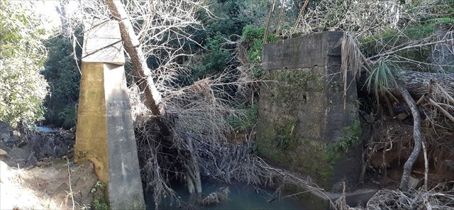
When out exploring this walkway I came across the remnants of the foundation piers/abutments of an old concrete bridge, it got me thinking about what was? and when?
So with a bit of a search at the Waitākere Central Library this article answered some of my questions:
"Deviation at Sunnyvale" (West Auckland Historical Society newsletter, August 2012, vol.344).
It confirmed what I had been thinking, that this was a railway bridge, part of the Western line that continued along what is now Seymour Road, which was diverted sometime in the 1940's.
Trains would cross the Waikumete stream at this point, heading towards Henderson, passing what was the Sunnyvale Railway Station.
For copyright reasons I have not included the black and white images of the station and bridge remnants with the cache page, you can easily search for them online (Railway bridge foundation piers near Sunnyvale Railway Station).
With the completion of the deviation this station was eventually demolished, the crossing point changing with the construction of the Waikumete bridge (1949).
As to why the deviation? well maybe a geocacher out there has the answer?
To learn more, read the original article at the library and visit the additional waypoints:
- Waikumete Bridge.
- Waikumete Stream Waterfall.

This is a letterbox cache, it is unique in that it is dual purpose. It can be a geocache (and the find is logged on the geocaching website) or is a letterbox hide (and the find can be recorded on the letterbox website).
SO WHAT IS A LETTERBOX CACHE?
It is based on Letterboxing which started in England in 1854, long before the GPS was invented.
Finders follow written instructions/clues to discover the container or the modern way is to use the posted coordinates on the geocaching cache page.
Each letterbox contains a logbook, and a rubber stamp.
When "letterboxers" find the container, they stamp the logbook with their personal stamp, and also stamp their own notebook with the stamp from the letterbox as a souvenir of their visit.
Please remember to leave this caches stamp and logbook in the container for the next finder.