WMT #2: Watery Artery
The 2nd cache of the series, a camo-taped 35mm film canister is hidden alongside the narrow trail as it heads west between the rear of the houses in this western suburb of East Morton to the south and the grassy farmland of the lower southern slopes of Rombalds Moor above to the north.
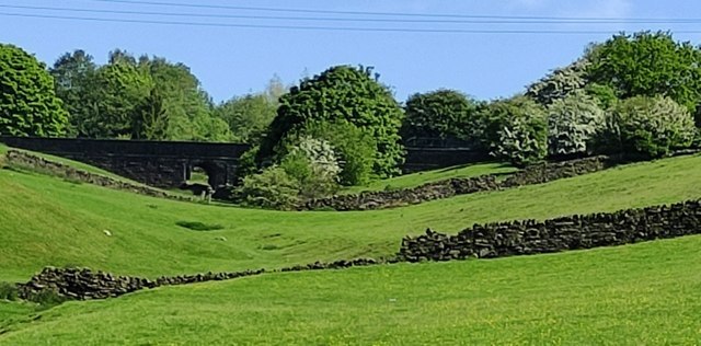
Looking up the field from the track, a strange, dark, solid stone bridge-like structure can be seen crossing a dip in the middle of the field. This is one of the few overground manifestations of the 22km Barden aqueduct which supplies several local towns with their drinking water. As such, this watery lifeline is probably the single most important structure you will see during your walk today!
This aqueduct is over 160 years old and a marvel of Victorian engineering which is still in remarkably good condition as confirmed during recent Yorkshire Water improvement works to this and the Nidd Aqueduct which feeds water from Upper Nidderdale to supply Bradford.
Completed in about 1860, it transfers around 30M litres of water per day from Lower Barden reservoir and water collected from the moors near Burnsall to Graincliffe water treatment works, at Eldwick north of Bradford. The water passes through tunnels and 42-inch diameter aqueducts (such as the one seen here) constructed from Yorkshire sandstone blocks.
Graincliffe works was built in the mid-1990s and supplies drinking water to Bingley, Baildon, Riddlesden, Otley, Heaton, Ilkley and also supports Keighley.

Another Barden viaduct in this area (apparently disused), which spans Brunthwaite beck, can be seen @ N 53 54.915 W 1 55.103 in Swartha Woods just east of Silsden. This impressive 1885 Yorkshire sandstone, 3-arched structure on tall piers is a Grade 2 protected building.
In Holden Clough, 1.5km south-east of Swartha @ N 53 54.386 W 1 54.041 the viaduct appears again as the huge pipe crosses Holden Gill just above a public footbridge (Lumb Bridge) and nearby waterfall (see photo blog here).

In East Morton @ N 53 52.681 W 1 50.845, an impressive viaduct crosses Morton Beck near Botany hamlet on the northern edge of the village. Although this is identified as part of the Nidd Viaduct, it is on a direct line with the others mentioned above and the end point of the Barden viaduct at Graincliffe works. Unlike the Nidd viaduct for which a route map is available (see here) no such map has been found for the Barden viaduct, so it is not known whether at East Morton they are one and the same . . .
Note: confusingly the name Barden Aqueduct is also used for Barden Bridge north of Bolton Abbey which is indeed an aqueduct but carries the Nidd Aqueduct system across the River Wharfe.
